Bear Canyon Butte Topo Map Oregon
To zoom in, hover over the map of Bear Canyon Butte
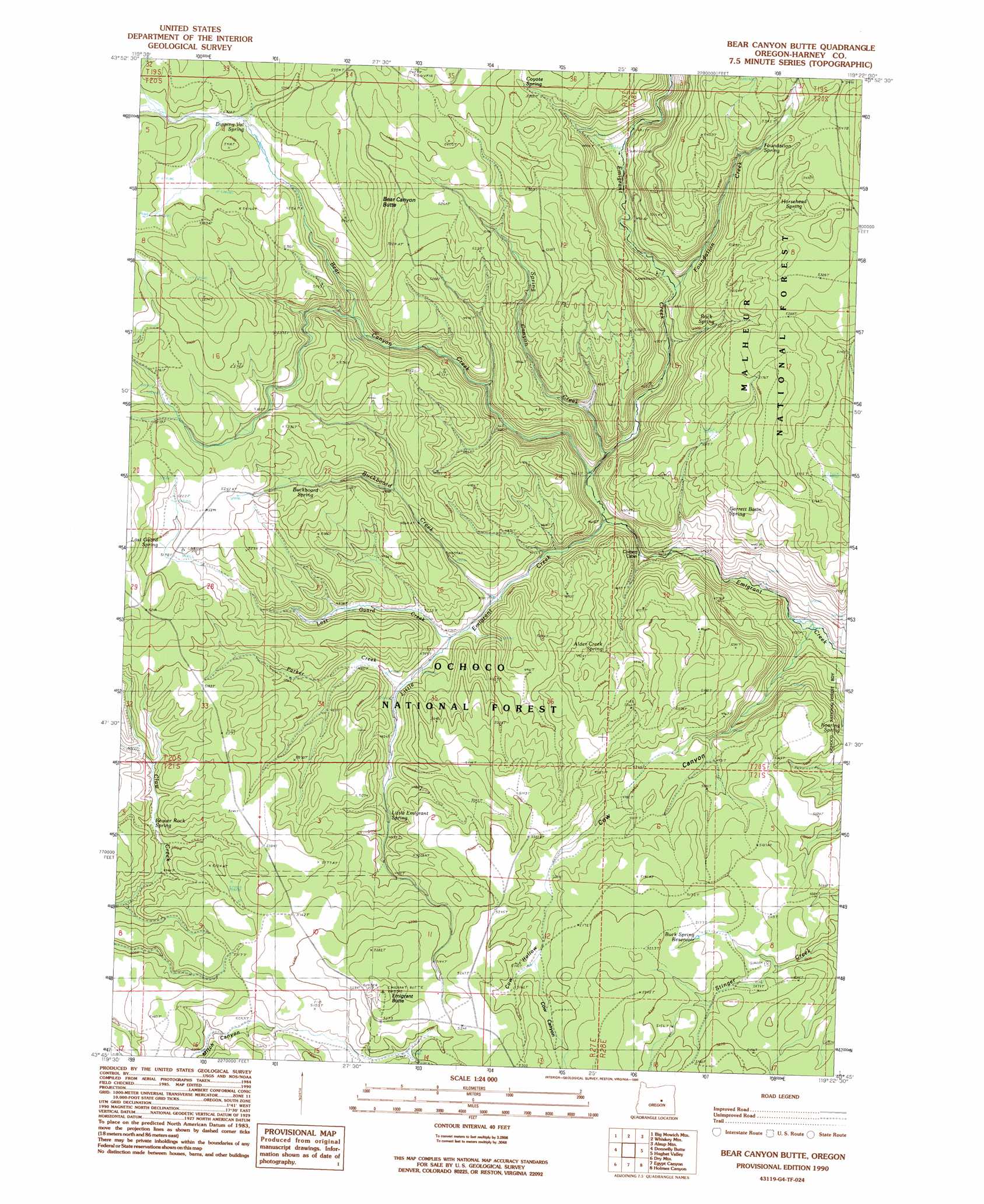
USGS Topo Quad 43119g4 - 1:24,000 scale
| Topo Map Name: | Bear Canyon Butte |
| USGS Topo Quad ID: | 43119g4 |
| Print Size: | ca. 21 1/4" wide x 27" high |
| Southeast Coordinates: | 43.75° N latitude / 119.375° W longitude |
| Map Center Coordinates: | 43.8125° N latitude / 119.4375° W longitude |
| U.S. State: | OR |
| Filename: | o43119g4.jpg |
| Download Map JPG Image: | Bear Canyon Butte topo map 1:24,000 scale |
| Map Type: | Topographic |
| Topo Series: | 7.5´ |
| Map Scale: | 1:24,000 |
| Source of Map Images: | United States Geological Survey (USGS) |
| Alternate Map Versions: |
Bear Canyon Butte OR 1990, updated 1990 Download PDF Buy paper map Bear Canyon Butte OR 1992, updated 1997 Download PDF Buy paper map Bear Canyon Butte OR 2011 Download PDF Buy paper map Bear Canyon Butte OR 2014 Download PDF Buy paper map |
| FStopo: | US Forest Service topo Bear Canyon Butte is available: Download FStopo PDF Download FStopo TIF |
1:24,000 Topo Quads surrounding Bear Canyon Butte
Suplee |
Funny Butte |
Izee |
Lewis Creek |
Five Hundred Flat |
Delintment Lake |
Big Mowich Mountain |
Whiskey Mountain |
Alsup Mountain |
West Myrtle Butte |
Buck Spring |
Donnelly Butte |
Bear Canyon Butte |
Hughet Valley |
Landing Creek |
Camp Currey Spring |
Dry Mountain |
Egypt Canyon |
Holmes Canyon |
Burns Ne |
Suntex |
Riley |
Oakerman Lakes |
Sage Hen Hill |
Burns Butte |
> Back to 43119e1 at 1:100,000 scale
> Back to 43118a1 at 1:250,000 scale
> Back to U.S. Topo Maps home
Bear Canyon Butte topo map: Gazetteer
Bear Canyon Butte: Reservoirs
Buck Spring Reservoir elevation 1570m 5150′Bear Canyon Butte: Springs
Alder Creek Spring elevation 1489m 4885′Beaver Rock Spring elevation 1519m 4983′
Buckboard Spring elevation 1559m 5114′
Cow Hollow Spring elevation 1567m 5141′
Coyote Spring elevation 1623m 5324′
Dipping Vat Spring elevation 1623m 5324′
Foundation Spring elevation 1638m 5374′
Garrett Basin Spring elevation 1505m 4937′
Horsehead Spring elevation 1623m 5324′
Little Emigrant Spring elevation 1504m 4934′
Lost Guard Spring elevation 1586m 5203′
Lost Spring elevation 1596m 5236′
Lost Spring elevation 1576m 5170′
Roaring Spring elevation 1479m 4852′
Rock Spring elevation 1544m 5065′
Bear Canyon Butte: Streams
Alder Creek elevation 1408m 4619′Bear Canyon Creek elevation 1417m 4648′
Buckboard Creek elevation 1442m 4730′
Foundation Creek elevation 1475m 4839′
Little Emigrant Creek elevation 1414m 4639′
Lost Guard Creek elevation 1450m 4757′
Parker Creek elevation 1455m 4773′
Spring Canyon Creek elevation 1415m 4642′
Bear Canyon Butte: Summits
Bear Canyon Butte elevation 1699m 5574′Emigrant Butte elevation 1639m 5377′
Bear Canyon Butte: Valleys
Cow Canyon elevation 1379m 4524′Cow Hollow elevation 1570m 5150′
Bear Canyon Butte digital topo map on disk
Buy this Bear Canyon Butte topo map showing relief, roads, GPS coordinates and other geographical features, as a high-resolution digital map file on DVD: