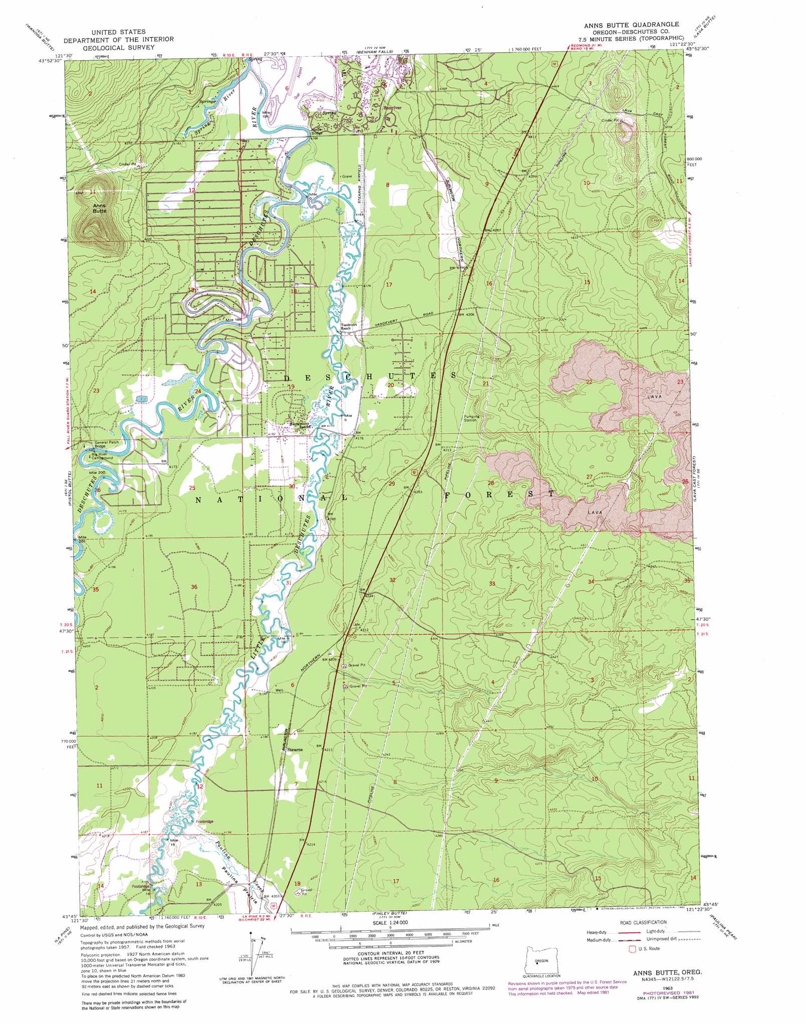
Anns Butte Topo Map Oregon
To zoom in, hover over the map of Anns Butte
USGS Topo Quad 43121g4 - 1:24,000 scale
| Topo Map Name: | Anns Butte |
| USGS Topo Quad ID: | 43121g4 |
| Print Size: | ca. 21 1/4" wide x 27" high |
| Southeast Coordinates: | 43.75° N latitude / 121.375° W longitude |
| Map Center Coordinates: | 43.8125° N latitude / 121.4375° W longitude |
| U.S. State: | OR |
| Filename: | o43121g4.jpg |
| Download Map JPG Image: | Anns Butte topo map 1:24,000 scale |
| Map Type: | Topographic |
| Topo Series: | 7.5´ |
| Map Scale: | 1:24,000 |
| Source of Map Images: | United States Geological Survey (USGS) |
| Alternate Map Versions: |
Anns Butte OR 1963, updated 1964 Download PDF Buy paper map Anns Butte OR 1963, updated 1975 Download PDF Buy paper map Anns Butte OR 1963, updated 1982 Download PDF Buy paper map Anns Butte OR 2011 Download PDF Buy paper map Anns Butte OR 2014 Download PDF Buy paper map |
| FStopo: | US Forest Service topo Anns Butte is available: Download FStopo PDF Download FStopo TIF |
1:24,000 Topo Quads surrounding Anns Butte
Lake Geneva |
Tumalo Falls |
Shevlin Park |
Bend |
Bend Airport |
Bachelor Butte |
Wanoga Butte |
Benham Falls |
Lava Butte |
Kelsey Butte |
Round Mountain |
Pistol Butte |
Anns Butte |
Lava Cast Forest |
Fuzztail Butte |
Wickiup Dam |
La Pine |
Finley Butte |
Paulina Peak |
East Lake |
Cryder Butte |
Masten Butte |
Moffitt Butte |
Spring Butte |
Indian Butte |
> Back to 43121e1 at 1:100,000 scale
> Back to 43120a1 at 1:250,000 scale
> Back to U.S. Topo Maps home
Anns Butte topo map: Gazetteer
Anns Butte: Airports
Sunriver Airport elevation 1268m 4160′Anns Butte: Bridges
Camp Abbot Bridge elevation 1292m 4238′General Patch Bridge (historical) elevation 1268m 4160′
Harper Bridge elevation 1269m 4163′
Montgomery Bridge elevation 1269m 4163′
Robert D. Maxwell Veterans Memorial Bridge elevation 1269m 4163′
Anns Butte: Populated Places
Three Rivers elevation 1276m 4186′Anns Butte: Post Offices
Carlisle Post Office (historical) elevation 1274m 4179′Crater Post Office (historical) elevation 1270m 4166′
Lava Post Office (historical) elevation 1279m 4196′
Anns Butte: Streams
Little Deschutes River elevation 1269m 4163′Paulina Creek elevation 1274m 4179′
Spring River elevation 1273m 4176′
Anns Butte: Summits
Anns Butte elevation 1447m 4747′Anns Butte digital topo map on disk
Buy this Anns Butte topo map showing relief, roads, GPS coordinates and other geographical features, as a high-resolution digital map file on DVD: