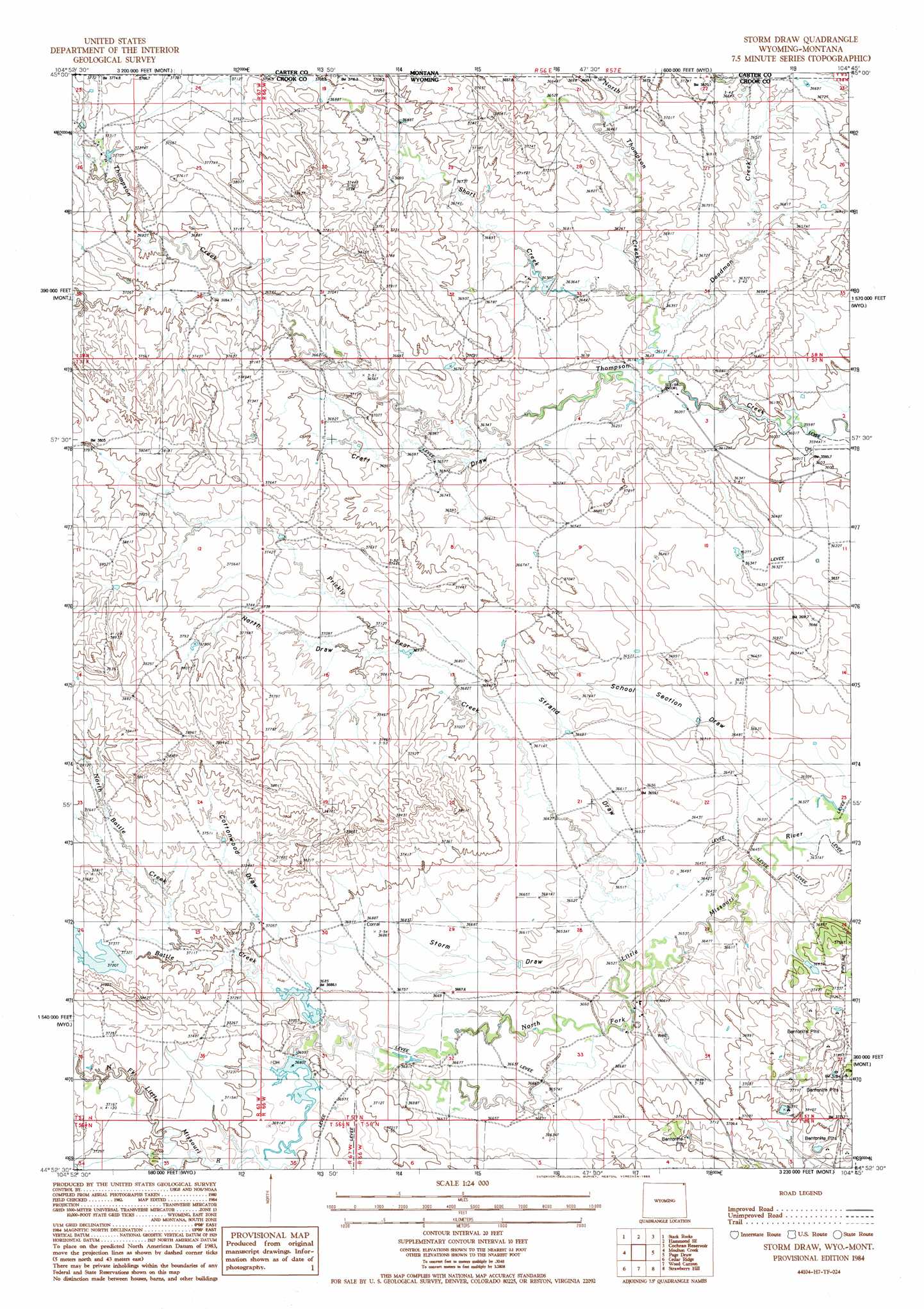
Storm Draw Topo Map Wyoming
To zoom in, hover over the map of Storm Draw
USGS Topo Quad 44104h7 - 1:24,000 scale
| Topo Map Name: | Storm Draw |
| USGS Topo Quad ID: | 44104h7 |
| Print Size: | ca. 21 1/4" wide x 27" high |
| Southeast Coordinates: | 44.875° N latitude / 104.75° W longitude |
| Map Center Coordinates: | 44.9375° N latitude / 104.8125° W longitude |
| U.S. States: | WY, MT |
| Filename: | o44104h7.jpg |
| Download Map JPG Image: | Storm Draw topo map 1:24,000 scale |
| Map Type: | Topographic |
| Topo Series: | 7.5´ |
| Map Scale: | 1:24,000 |
| Source of Map Images: | United States Geological Survey (USGS) |
| Alternate Map Versions: |
Storm Draw WY 1984, updated 1985 Download PDF Buy paper map Storm Draw WY 2011 Download PDF Buy paper map Storm Draw WY 2012 Download PDF Buy paper map Storm Draw WY 2015 Download PDF Buy paper map |
1:24,000 Topo Quads surrounding Storm Draw
Belle Creek North |
Hammond |
Greasy Hill |
Black Point |
Black Point Ne |
Belle Creek South |
Stack Rocks |
Hammond Se |
Cochran Reservoir |
Gomer Draw |
Rockypoint |
Moulton Creek |
Storm Draw |
Page Draw |
Gaff Creek |
Bonnie Reservoir |
Cedar Ridge |
Wood Canyon |
Strawberry Hill |
Seely |
Brislawn School |
Garland Hill |
New Haven |
Moore Hill |
Hulett |
> Back to 44104e1 at 1:100,000 scale
> Back to 44104a1 at 1:250,000 scale
> Back to U.S. Topo Maps home
Storm Draw topo map: Gazetteer
Storm Draw: Dams
Battle Creek Dam elevation 1134m 3720′Bush Ranch Dam elevation 1108m 3635′
Tract 37 Dam elevation 1124m 3687′
Storm Draw: Reservoirs
Battle Creek Reservoir elevation 1134m 3720′Bush Ranch Reservoir elevation 1108m 3635′
Tract 37 Reservoir elevation 1124m 3687′
Storm Draw: Streams
Battle Creek elevation 1119m 3671′Cedar Creek elevation 1125m 3690′
Deadman Creek elevation 1100m 3608′
Deadman Creek elevation 1100m 3608′
North Battle Creek elevation 1122m 3681′
North Thompson Creek elevation 1099m 3605′
Prickly Pear Creek elevation 1108m 3635′
Short Creek elevation 1101m 3612′
Short Creek elevation 1102m 3615′
Storm Draw: Valleys
Cottonwood Draw elevation 1128m 3700′Craft Draw elevation 1104m 3622′
North Draw elevation 1127m 3697′
School Section Draw elevation 1107m 3631′
Storm Draw elevation 1112m 3648′
Strand Draw elevation 1112m 3648′
Storm Draw digital topo map on disk
Buy this Storm Draw topo map showing relief, roads, GPS coordinates and other geographical features, as a high-resolution digital map file on DVD:
Eastern Wyoming & Western South Dakota
Buy digital topo maps: Eastern Wyoming & Western South Dakota