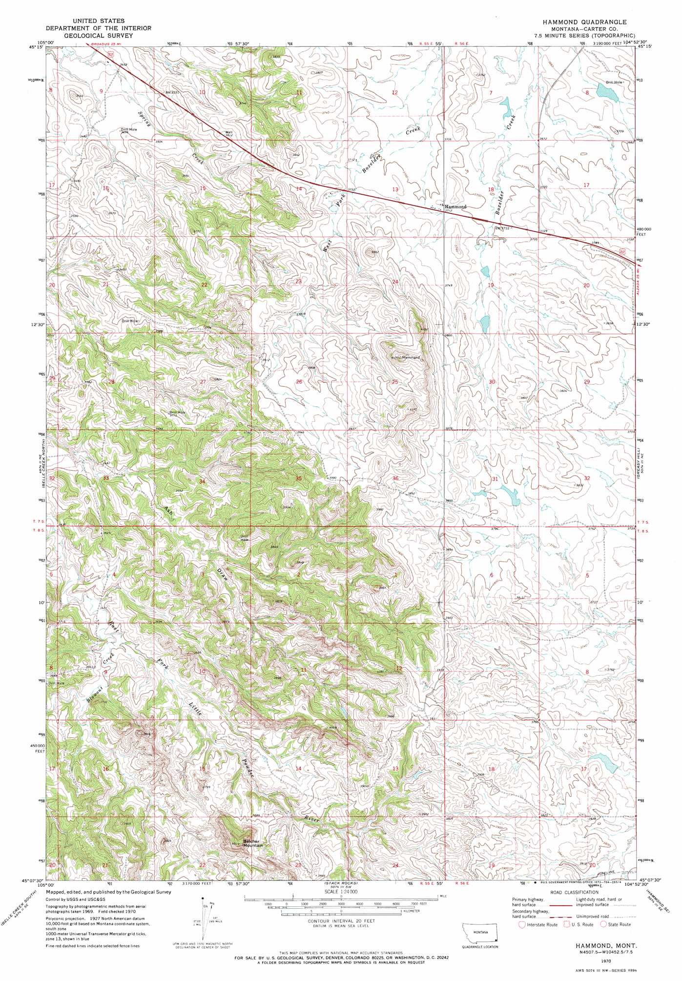
Hammond Topo Map Montana
To zoom in, hover over the map of Hammond
USGS Topo Quad 45104b8 - 1:24,000 scale
| Topo Map Name: | Hammond |
| USGS Topo Quad ID: | 45104b8 |
| Print Size: | ca. 21 1/4" wide x 27" high |
| Southeast Coordinates: | 45.125° N latitude / 104.875° W longitude |
| Map Center Coordinates: | 45.1875° N latitude / 104.9375° W longitude |
| U.S. State: | MT |
| Filename: | o45104b8.jpg |
| Download Map JPG Image: | Hammond topo map 1:24,000 scale |
| Map Type: | Topographic |
| Topo Series: | 7.5´ |
| Map Scale: | 1:24,000 |
| Source of Map Images: | United States Geological Survey (USGS) |
| Alternate Map Versions: |
Hammond MT 1970, updated 1973 Download PDF Buy paper map Hammond MT 2011 Download PDF Buy paper map Hammond MT 2014 Download PDF Buy paper map |
1:24,000 Topo Quads surrounding Hammond
Little Pilgrim Butte |
Lightning Butte |
Pentecost Reservoir |
Knudson Draw Ne |
Whitetail Creek |
Dry Creek Butte |
Boyes |
Knudson Draw |
Phillipi Reservoir |
Tip Top Butte |
Sanburn Reservoir |
Belle Creek North |
Hammond |
Greasy Hill |
Black Point |
Belle Creek Sw |
Belle Creek South |
Stack Rocks |
Hammond Se |
Cochran Reservoir |
Mitten Butte |
Rockypoint |
Moulton Creek |
Storm Draw |
Page Draw |
> Back to 45104a1 at 1:100,000 scale
> Back to 45104a1 at 1:250,000 scale
> Back to U.S. Topo Maps home
Hammond topo map: Gazetteer
Hammond: Dams
Aldrich Dam elevation 1160m 3805′Gerald Craft Number 3 Dam elevation 1162m 3812′
Gerald Craft Number 5 Dam elevation 1140m 3740′
Velvet Dam elevation 1118m 3667′
Hammond: Populated Places
Hammond elevation 1132m 3713′Hammond: Post Offices
Hammond Post Office elevation 1133m 3717′Hammond: Streams
Blowout Creek elevation 1062m 3484′Hammond: Summits
Belcher Mountain elevation 1222m 4009′Hammond: Wells
07S55E11BDCA01 Well elevation 1127m 3697′07S55E14BB__01 Well elevation 1141m 3743′
07S55E33CAA_01 Well elevation 1072m 3517′
08S55E01AD__01 Well elevation 1175m 3854′
08S55E02DDDB01 Well elevation 1136m 3727′
08S55E04CDAC01 Well elevation 1059m 3474′
08S55E10CB__01 Well elevation 1074m 3523′
Hammond digital topo map on disk
Buy this Hammond topo map showing relief, roads, GPS coordinates and other geographical features, as a high-resolution digital map file on DVD:
Eastern Montana & Western North Dakota
Buy digital topo maps: Eastern Montana & Western North Dakota