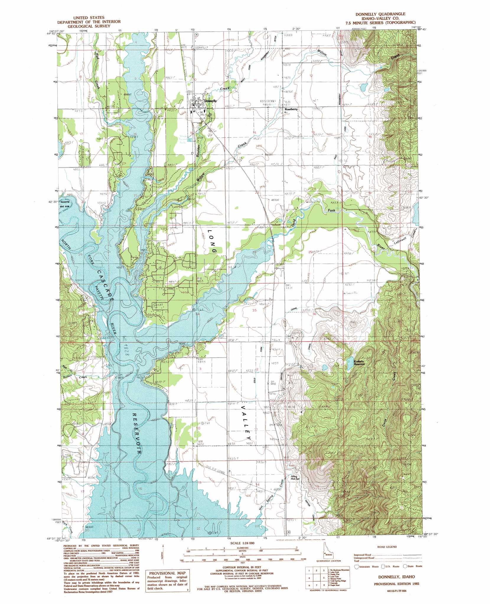
Donnelly Topo Map Idaho
To zoom in, hover over the map of Donnelly
USGS Topo Quad 44116f1 - 1:24,000 scale
| Topo Map Name: | Donnelly |
| USGS Topo Quad ID: | 44116f1 |
| Print Size: | ca. 21 1/4" wide x 27" high |
| Southeast Coordinates: | 44.625° N latitude / 116° W longitude |
| Map Center Coordinates: | 44.6875° N latitude / 116.0625° W longitude |
| U.S. State: | ID |
| Filename: | o44116f1.jpg |
| Download Map JPG Image: | Donnelly topo map 1:24,000 scale |
| Map Type: | Topographic |
| Topo Series: | 7.5´ |
| Map Scale: | 1:24,000 |
| Source of Map Images: | United States Geological Survey (USGS) |
| Alternate Map Versions: |
Donnelly ID 1985, updated 1986 Download PDF Buy paper map Donnelly ID 2011 Download PDF Buy paper map Donnelly ID 2013 Download PDF Buy paper map |
| FStopo: | US Forest Service topo Donnelly is available: Download FStopo PDF Download FStopo TIF |
1:24,000 Topo Quads surrounding Donnelly
New Meadows |
Meadows |
Mccall |
Fitsum Summit |
Fitsum Peak |
Cold Spring Summit |
No Business Mountain |
Lake Fork |
Paddy Flat |
Blackmare |
Council Mountain |
Lone Tree |
Donnelly |
Sloans Point |
Gold Fork Rock |
King Hill Creek |
Cold Spring Ridge |
Cascade |
Eagle Nest |
Oro Mountain |
Twin Sisters |
Tripod Peak |
Alpha |
Skunk Creek Summit |
Bull Creek Hot Springs |
> Back to 44116e1 at 1:100,000 scale
> Back to 44116a1 at 1:250,000 scale
> Back to U.S. Topo Maps home
Donnelly topo map: Gazetteer
Donnelly: Airports
Donnelly Airport elevation 1479m 4852′Donnelly: Canals
East Fork Roseberry Ditch elevation 1488m 4881′Gold Fork Canal elevation 1482m 4862′
Donnelly: Dams
Eld Dam elevation 1496m 4908′Koskella Dam elevation 1516m 4973′
Donnelly: Populated Places
Arling elevation 1474m 4835′Donnelly elevation 1483m 4865′
MacGregor (historical) elevation 1481m 4858′
Roseberry elevation 1486m 4875′
Donnelly: Reservoirs
Koskella Reservoir elevation 1516m 4973′Donnelly: Springs
Arling Hot Spring elevation 1482m 4862′Donnelly: Streams
Boulder Creek elevation 1473m 4832′Davis Creek elevation 1473m 4832′
Gold Fork River elevation 1473m 4832′
Laffinwell Creek elevation 1482m 4862′
Lake Fork elevation 1473m 4832′
Mud Creek elevation 1473m 4832′
Poison Creek elevation 1473m 4832′
Rock Creek elevation 1473m 4832′
Willow Creek elevation 1473m 4832′
Donnelly digital topo map on disk
Buy this Donnelly topo map showing relief, roads, GPS coordinates and other geographical features, as a high-resolution digital map file on DVD: