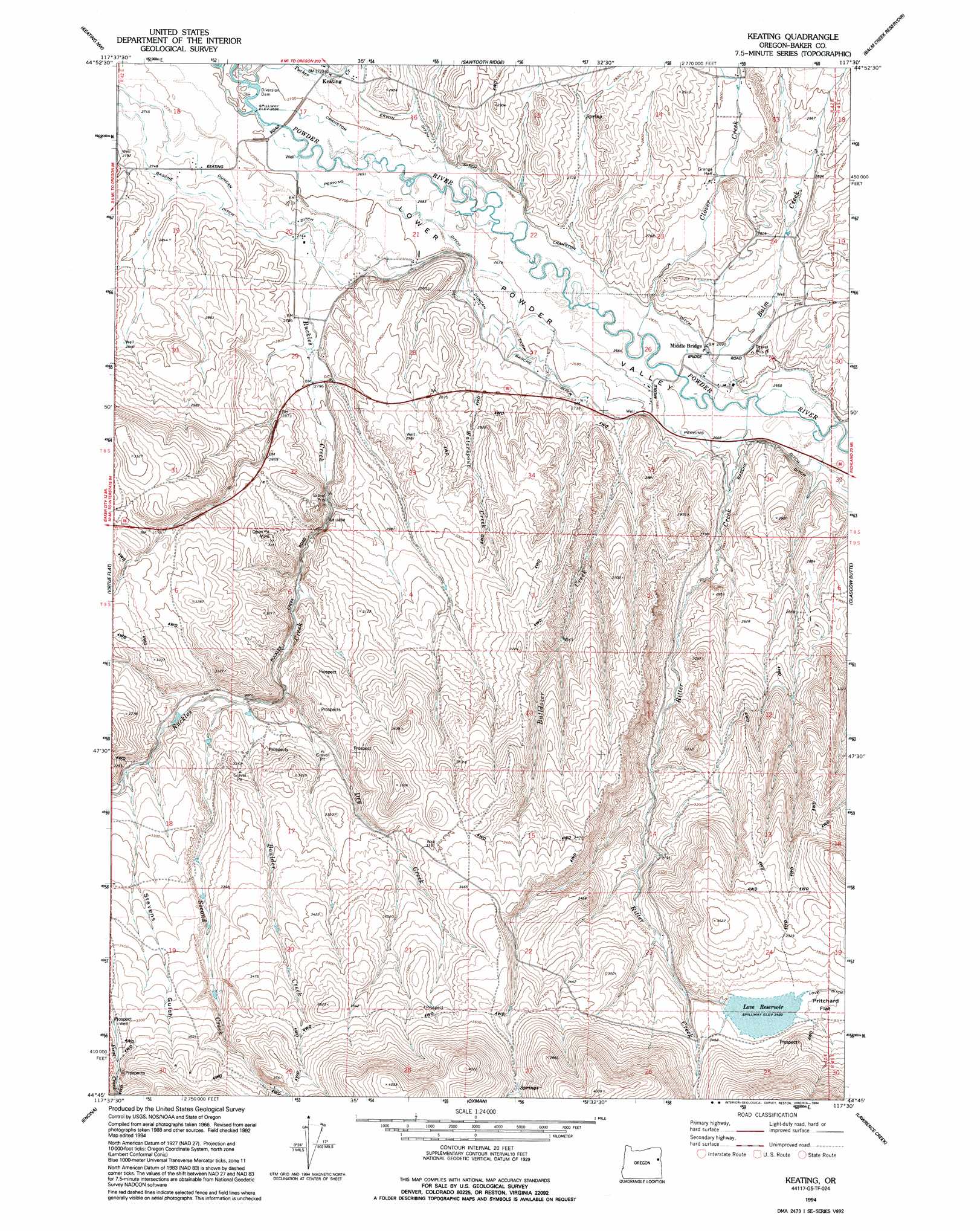
Keating Topo Map Oregon
To zoom in, hover over the map of Keating
USGS Topo Quad 44117g5 - 1:24,000 scale
| Topo Map Name: | Keating |
| USGS Topo Quad ID: | 44117g5 |
| Print Size: | ca. 21 1/4" wide x 27" high |
| Southeast Coordinates: | 44.75° N latitude / 117.5° W longitude |
| Map Center Coordinates: | 44.8125° N latitude / 117.5625° W longitude |
| U.S. State: | OR |
| Filename: | o44117g5.jpg |
| Download Map JPG Image: | Keating topo map 1:24,000 scale |
| Map Type: | Topographic |
| Topo Series: | 7.5´ |
| Map Scale: | 1:24,000 |
| Source of Map Images: | United States Geological Survey (USGS) |
| Alternate Map Versions: |
Keating OR 1967, updated 1971 Download PDF Buy paper map Keating OR 1994, updated 1994 Download PDF Buy paper map Keating OR 2011 Download PDF Buy paper map Keating OR 2014 Download PDF Buy paper map |
| FStopo: | US Forest Service topo Keating is available: Download FStopo PDF Download FStopo TIF |
1:24,000 Topo Quads surrounding Keating
Telocaset |
Medical Springs |
Flagstaff Butte |
Bennet Peak |
Krag Peak |
Magpie Peak |
Keating Nw |
Sawtooth Ridge |
Balm Creek Reservoir |
Sparta Butte |
Baker |
Virtue Flat |
Keating |
Glasgow Butte |
Sparta |
Bowen Valley |
Encina |
Oxman |
Lawrence Creek |
Little Lookout Mountain |
Dooley Mountain |
French Gulch |
Lost Basin |
Durkee |
Big Lookout Mountain |
> Back to 44117e1 at 1:100,000 scale
> Back to 44116a1 at 1:250,000 scale
> Back to U.S. Topo Maps home
Keating topo map: Gazetteer
Keating: Basins
Lower Powder Valley elevation 817m 2680′Keating: Canals
Cranston Ditch elevation 823m 2700′Love Ditch elevation 1050m 3444′
Perkins Ditch elevation 825m 2706′
Keating: Dams
Love Dam elevation 1044m 3425′Keating: Populated Places
Keating elevation 830m 2723′Keating: Post Offices
Keating Post Office (historical) elevation 830m 2723′Prichard Post Office (historical) elevation 809m 2654′
Keating: Reservoirs
Constance Reservoir elevation 953m 3126′Cranston Reservoir elevation 825m 2706′
Love Reservoir elevation 1042m 3418′
Keating: Springs
McCann Spring elevation 836m 2742′Keating: Streams
Balm Creek elevation 807m 2647′Boulder Creek elevation 929m 3047′
Bulldozer Creek elevation 831m 2726′
Clover Creek elevation 812m 2664′
Dry Creek elevation 930m 3051′
East Clover Creek elevation 852m 2795′
Ritter Creek elevation 807m 2647′
Ruckles Creek elevation 824m 2703′
Second Creek elevation 931m 3054′
Tucker Creek elevation 824m 2703′
Waterspout Creek elevation 836m 2742′
Keating: Valleys
Stevens Gulch elevation 970m 3182′Keating digital topo map on disk
Buy this Keating topo map showing relief, roads, GPS coordinates and other geographical features, as a high-resolution digital map file on DVD: