Medunkeunk Lake Topo Map Maine
To zoom in, hover over the map of Medunkeunk Lake
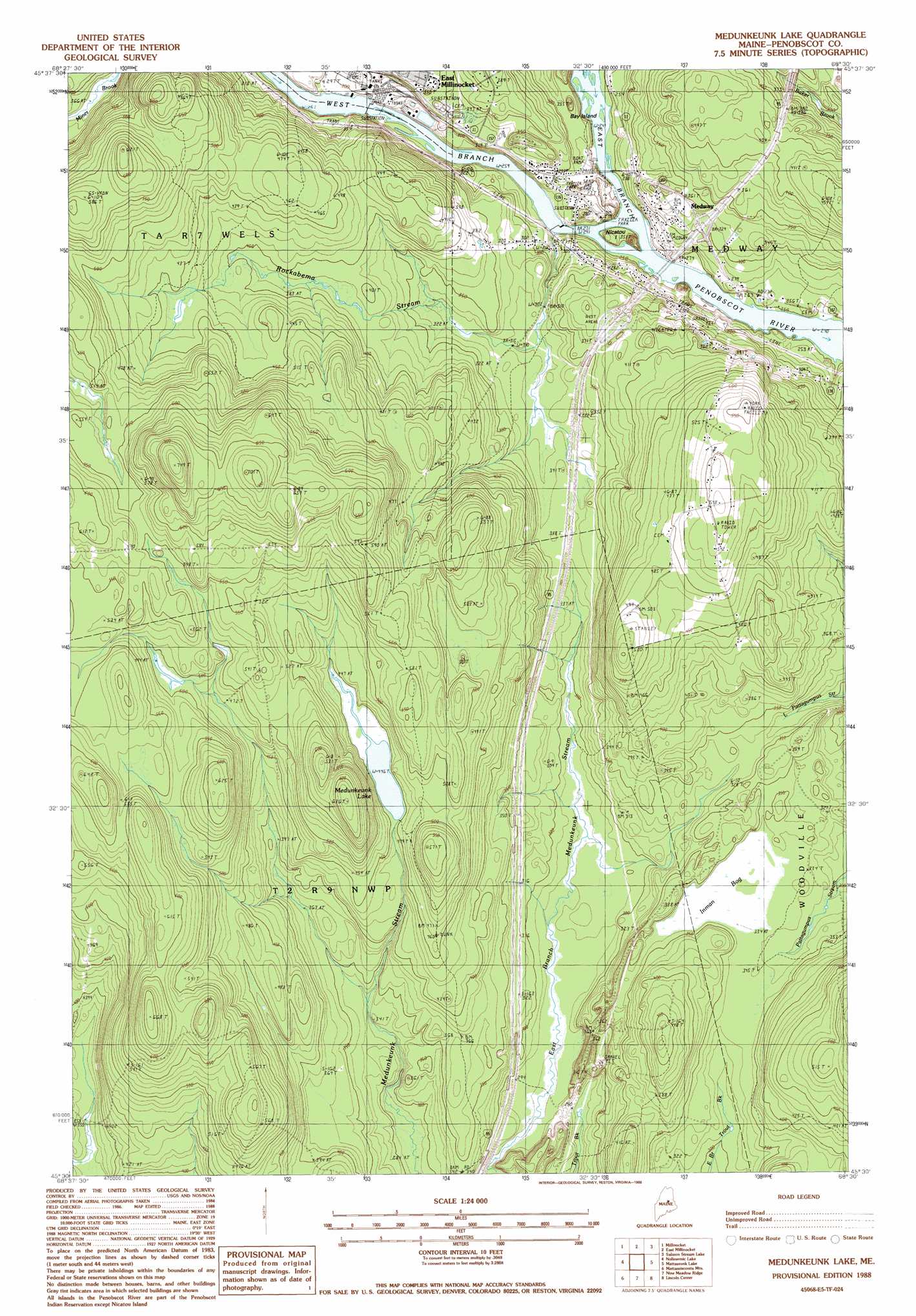
USGS Topo Quad 45068e5 - 1:24,000 scale
| Topo Map Name: | Medunkeunk Lake |
| USGS Topo Quad ID: | 45068e5 |
| Print Size: | ca. 21 1/4" wide x 27" high |
| Southeast Coordinates: | 45.5° N latitude / 68.5° W longitude |
| Map Center Coordinates: | 45.5625° N latitude / 68.5625° W longitude |
| U.S. State: | ME |
| Filename: | o45068e5.jpg |
| Download Map JPG Image: | Medunkeunk Lake topo map 1:24,000 scale |
| Map Type: | Topographic |
| Topo Series: | 7.5´ |
| Map Scale: | 1:24,000 |
| Source of Map Images: | United States Geological Survey (USGS) |
| Alternate Map Versions: |
Millinocket SE ME 1975, updated 1980 Download PDF Buy paper map Medunkeunk Lake ME 1988, updated 1988 Download PDF Buy paper map Medunkeunk Lake ME 2011 Download PDF Buy paper map Medunkeunk Lake ME 2014 Download PDF Buy paper map |
1:24,000 Topo Quads surrounding Medunkeunk Lake
Trout Mountain |
Whetstone Mountain |
Stacyville |
Benedicta |
Monarda |
Norcross |
Millinocket |
East Millinocket |
Salmon Stream Lake |
Molunkid Lake |
Cedar Lake |
Nollesemic Lake |
Medunkeunk Lake |
Mattaseunk Lake |
Mattawamkeag |
Endless Lake |
Mattamiscontis Mountain |
Nine Meadow Ridge |
Lincoln Center |
East Winn |
Hardy Pond |
Seboeis |
Lincoln West |
Lincoln East |
Lee |
> Back to 45068e1 at 1:100,000 scale
> Back to 45068a1 at 1:250,000 scale
> Back to U.S. Topo Maps home
Medunkeunk Lake topo map: Gazetteer
Medunkeunk Lake: Crossings
Interchange 56 elevation 113m 370′Medunkeunk Lake: Dams
East Millinocket Dam elevation 79m 259′Medway Dam elevation 79m 259′
Medunkeunk Lake: Islands
Bay Island elevation 73m 239′Nicatou Island elevation 84m 275′
Medunkeunk Lake: Lakes
Medunkeunk Lake elevation 136m 446′Medunkeunk Lake: Populated Places
Medway elevation 87m 285′Oak Park Manor elevation 118m 387′
Silverwood Court elevation 107m 351′
Medunkeunk Lake: Reservoirs
West Branch Penobscot River Reservoir elevation 79m 259′Medunkeunk Lake: Streams
East Branch Penobscot River elevation 73m 239′Rockabema Stream elevation 78m 255′
West Branch Penobscot River elevation 73m 239′
Medunkeunk Lake: Swamps
Inman Bog elevation 102m 334′Medunkeunk Lake digital topo map on disk
Buy this Medunkeunk Lake topo map showing relief, roads, GPS coordinates and other geographical features, as a high-resolution digital map file on DVD:
Maine, New Hampshire, Rhode Island & Eastern Massachusetts
Buy digital topo maps: Maine, New Hampshire, Rhode Island & Eastern Massachusetts