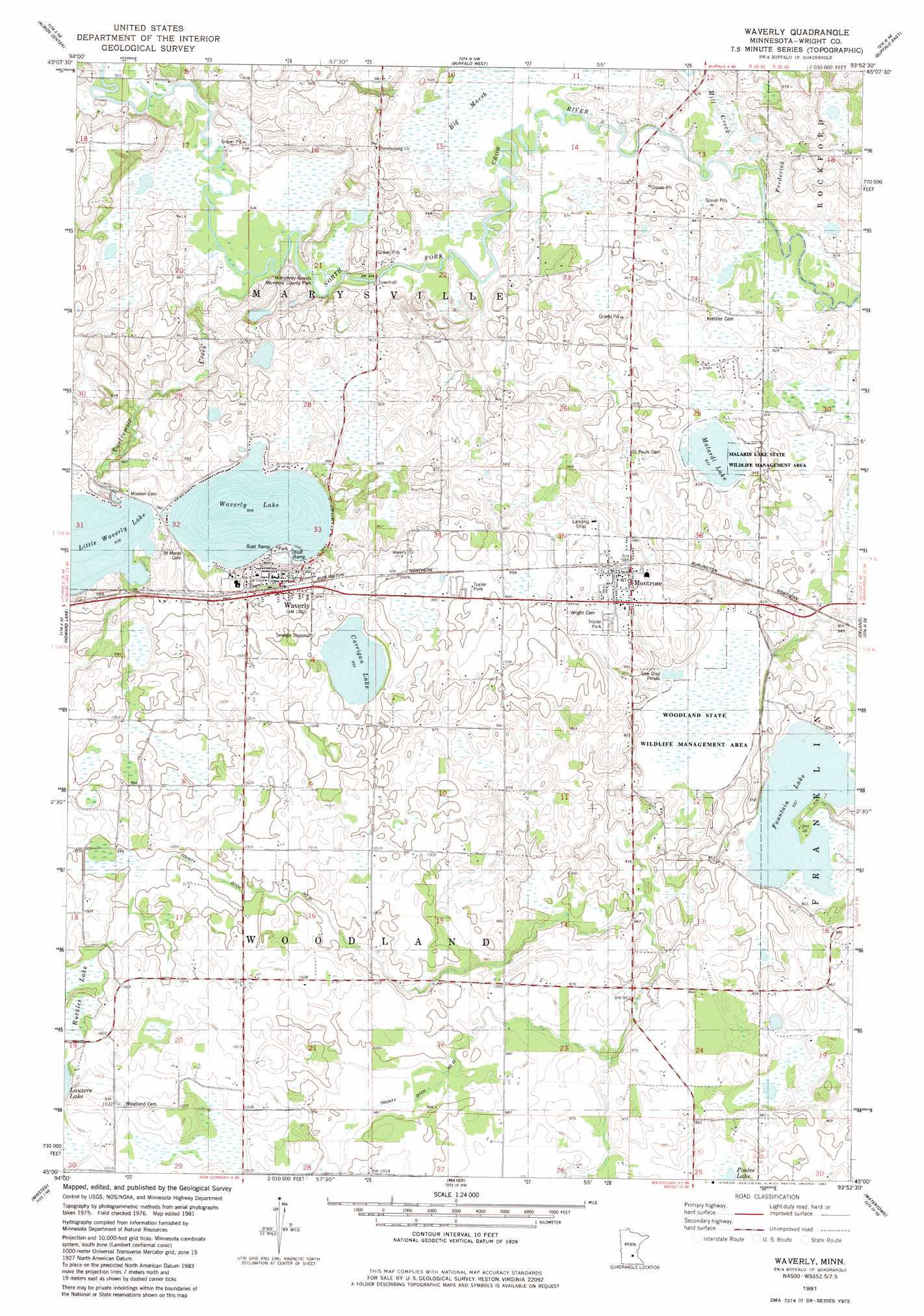
Waverly Topo Map Minnesota
To zoom in, hover over the map of Waverly
USGS Topo Quad 45093a8 - 1:24,000 scale
| Topo Map Name: | Waverly |
| USGS Topo Quad ID: | 45093a8 |
| Print Size: | ca. 21 1/4" wide x 27" high |
| Southeast Coordinates: | 45° N latitude / 93.875° W longitude |
| Map Center Coordinates: | 45.0625° N latitude / 93.9375° W longitude |
| U.S. State: | MN |
| Filename: | o45093a8.jpg |
| Download Map JPG Image: | Waverly topo map 1:24,000 scale |
| Map Type: | Topographic |
| Topo Series: | 7.5´ |
| Map Scale: | 1:24,000 |
| Source of Map Images: | United States Geological Survey (USGS) |
| Alternate Map Versions: |
Waverly MN 1981, updated 1982 Download PDF Buy paper map Waverly MN 2010 Download PDF Buy paper map Waverly MN 2013 Download PDF Buy paper map Waverly MN 2016 Download PDF Buy paper map |
1:24,000 Topo Quads surrounding Waverly
South Haven |
Annandale |
Silver Creek |
Monticello |
Big Lake |
French Lake |
Albion Center |
Buffalo West |
Buffalo East |
Saint Michael |
Cokato |
Howard Lake |
Waverly |
Delano |
Rockford |
Silver Lake |
Winsted |
Mayer |
Watertown |
Mound |
Glenco |
Plato |
Norwood |
Waconia |
Victoria |
> Back to 45093a1 at 1:100,000 scale
> Back to 45092a1 at 1:250,000 scale
> Back to U.S. Topo Maps home
Waverly topo map: Gazetteer
Waverly: Airports
Fountain Lake Seaplane Base elevation 287m 941′Waverly: Canals
County Ditch Number Thirtyone elevation 305m 1000′County Ditch Number Twentytwo elevation 302m 990′
Waverly: Dams
Little Waverly Dam elevation 297m 974′Woodland State Wildlife Management Area elevation 281m 921′
Waverly: Lakes
Carrigan Lake elevation 303m 994′Fountain Lake elevation 284m 931′
Little Waverly Lake elevation 291m 954′
Malardi Lake elevation 284m 931′
Waverly Lake elevation 291m 954′
Waverly: Parks
Humphrey-Arends Memorial County Park elevation 281m 921′Malardi Lake State Wildlife Management Area elevation 284m 931′
Waverly: Populated Places
Montrose elevation 303m 994′Montrose Manor Mobile Home Park elevation 299m 980′
Twelve Hi Mobile Home Estates elevation 304m 997′
Waverly elevation 307m 1007′
Waverly: Post Offices
Montrose Post Office elevation 303m 994′North Saint Paul Post Office (historical) elevation 309m 1013′
Waverly Post Office elevation 308m 1010′
Waverly: Reservoirs
Little Waverly Lake elevation 297m 974′Mud Lake elevation 281m 921′
Waverly: Streams
Frederick Creek elevation 277m 908′Mill Creek elevation 278m 912′
Twelvemile Creek elevation 281m 921′
Waverly digital topo map on disk
Buy this Waverly topo map showing relief, roads, GPS coordinates and other geographical features, as a high-resolution digital map file on DVD: