Mound Topo Map Minnesota
To zoom in, hover over the map of Mound
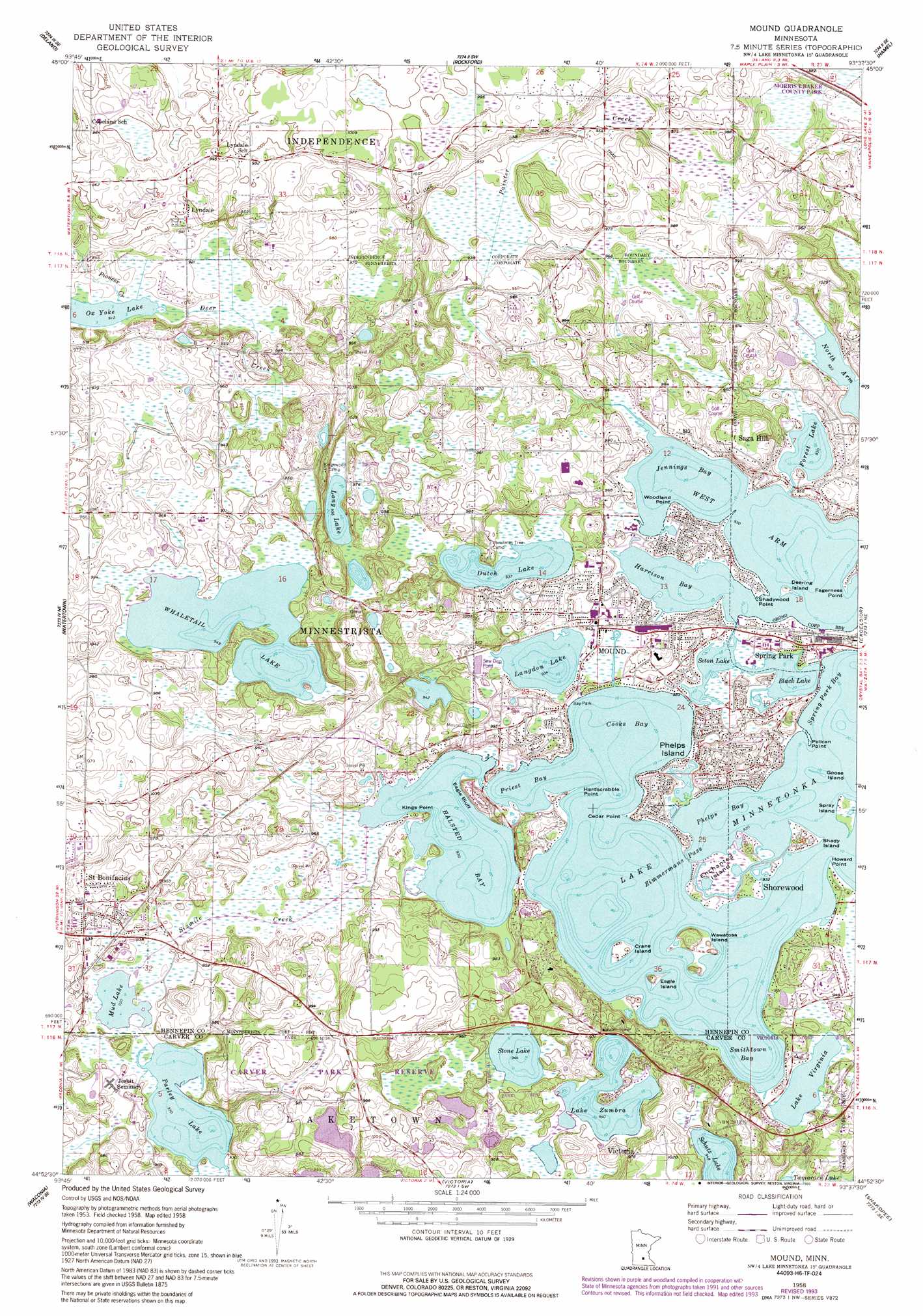
USGS Topo Quad 44093h6 - 1:24,000 scale
| Topo Map Name: | Mound |
| USGS Topo Quad ID: | 44093h6 |
| Print Size: | ca. 21 1/4" wide x 27" high |
| Southeast Coordinates: | 44.875° N latitude / 93.625° W longitude |
| Map Center Coordinates: | 44.9375° N latitude / 93.6875° W longitude |
| U.S. State: | MN |
| Filename: | o44093h6.jpg |
| Download Map JPG Image: | Mound topo map 1:24,000 scale |
| Map Type: | Topographic |
| Topo Series: | 7.5´ |
| Map Scale: | 1:24,000 |
| Source of Map Images: | United States Geological Survey (USGS) |
| Alternate Map Versions: |
Mound MN 1958, updated 1959 Download PDF Buy paper map Mound MN 1958, updated 1974 Download PDF Buy paper map Mound MN 1958, updated 1986 Download PDF Buy paper map Mound MN 1958, updated 1993 Download PDF Buy paper map Mound MN 2010 Download PDF Buy paper map Mound MN 2013 Download PDF Buy paper map Mound MN 2016 Download PDF Buy paper map |
1:24,000 Topo Quads surrounding Mound
Buffalo West |
Buffalo East |
Saint Michael |
Rogers |
Anoka |
Waverly |
Delano |
Rockford |
Hamel |
Osseo |
Mayer |
Watertown |
Mound |
Excelsior |
Hopkins |
Norwood |
Waconia |
Victoria |
Shakopee |
Eden Prairie |
Hamburg |
Belle Plaine North |
Jordan West |
Jordan East |
Prior Lake |
> Back to 44093e1 at 1:100,000 scale
> Back to 44092a1 at 1:250,000 scale
> Back to U.S. Topo Maps home
Mound topo map: Gazetteer
Mound: Airports
Flobacks Seaplane Base elevation 289m 948′Peil-Juliar Seaplane Base elevation 299m 980′
Mound: Bays
Cooks Bay elevation 285m 935′Halsted Bay elevation 285m 935′
Harrison Bay elevation 285m 935′
Jennings Bay elevation 285m 935′
Phelps Bay elevation 285m 935′
Priest Bay elevation 285m 935′
Smithtown Bay elevation 285m 935′
Spring Park Bay elevation 285m 935′
West Arm elevation 285m 935′
Mound: Bridges
Emerald Lake Bridge elevation 285m 935′Forest Lake Bridge elevation 286m 938′
Halsted Bay Bridge elevation 285m 935′
Halsted Bay Bridge elevation 285m 935′
Seton Bridge elevation 286m 938′
Mound: Capes
Cedar Point elevation 297m 974′Fagerness Point elevation 286m 938′
Hardscrabble Point elevation 285m 935′
Howard Point elevation 286m 938′
Kings Point elevation 288m 944′
Pelican Point elevation 286m 938′
Shadywood Point elevation 287m 941′
Skogsber Point elevation 286m 938′
Woodland Point elevation 288m 944′
Mound: Channels
Zimmermans Pass elevation 285m 935′Mound: Cliffs
Eagle Bluff elevation 286m 938′Mound: Dams
Lunsten Lake Dam elevation 312m 1023′Mound: Islands
Crane Island elevation 289m 948′Deering Island elevation 288m 944′
Eagle Island elevation 291m 954′
Enchanted Island elevation 286m 938′
Goose Island elevation 285m 935′
Phelps Island elevation 308m 1010′
Shady Island elevation 290m 951′
Spray Island elevation 285m 935′
Wawatosa Island elevation 294m 964′
Mound: Lakes
Black Lake elevation 285m 935′Dutch Lake elevation 285m 935′
Emerald Lake elevation 285m 935′
Forest Lake elevation 285m 935′
Lake Minnetonka elevation 285m 935′
Lake Virginia elevation 285m 935′
Lake Zumbra elevation 288m 944′
Langdon Lake elevation 285m 935′
Long Lake elevation 291m 954′
Mud Lake elevation 285m 935′
Ox Yoke Lake elevation 278m 912′
Parley Lake elevation 285m 935′
Seton Lake elevation 285m 935′
Stone Lake elevation 288m 944′
Whaletail Lake elevation 288m 944′
Mound: Parks
Bay Park elevation 286m 938′Lake Minnetonka Regional Park elevation 288m 944′
Mound: Populated Places
Island Park elevation 289m 948′Lyndale elevation 288m 944′
Minnetrista elevation 288m 944′
Mound elevation 287m 941′
Saga Hill elevation 299m 980′
Saint Bonifacius elevation 296m 971′
Spring Park elevation 290m 951′
Mound: Post Offices
Island Park Post Office (historical) elevation 288m 944′Lyndale Post Office (historical) elevation 288m 944′
Minnetrista Post Office (historical) elevation 288m 944′
Mound: Reservoirs
Lunsten Lake elevation 312m 1023′Mound: Streams
Painter Creek elevation 285m 935′Pioneer Creek elevation 278m 912′
Sixmile Creek elevation 285m 935′
Mound digital topo map on disk
Buy this Mound topo map showing relief, roads, GPS coordinates and other geographical features, as a high-resolution digital map file on DVD: