Bar V Ranch Ne Topo Map Montana
To zoom in, hover over the map of Bar V Ranch Ne
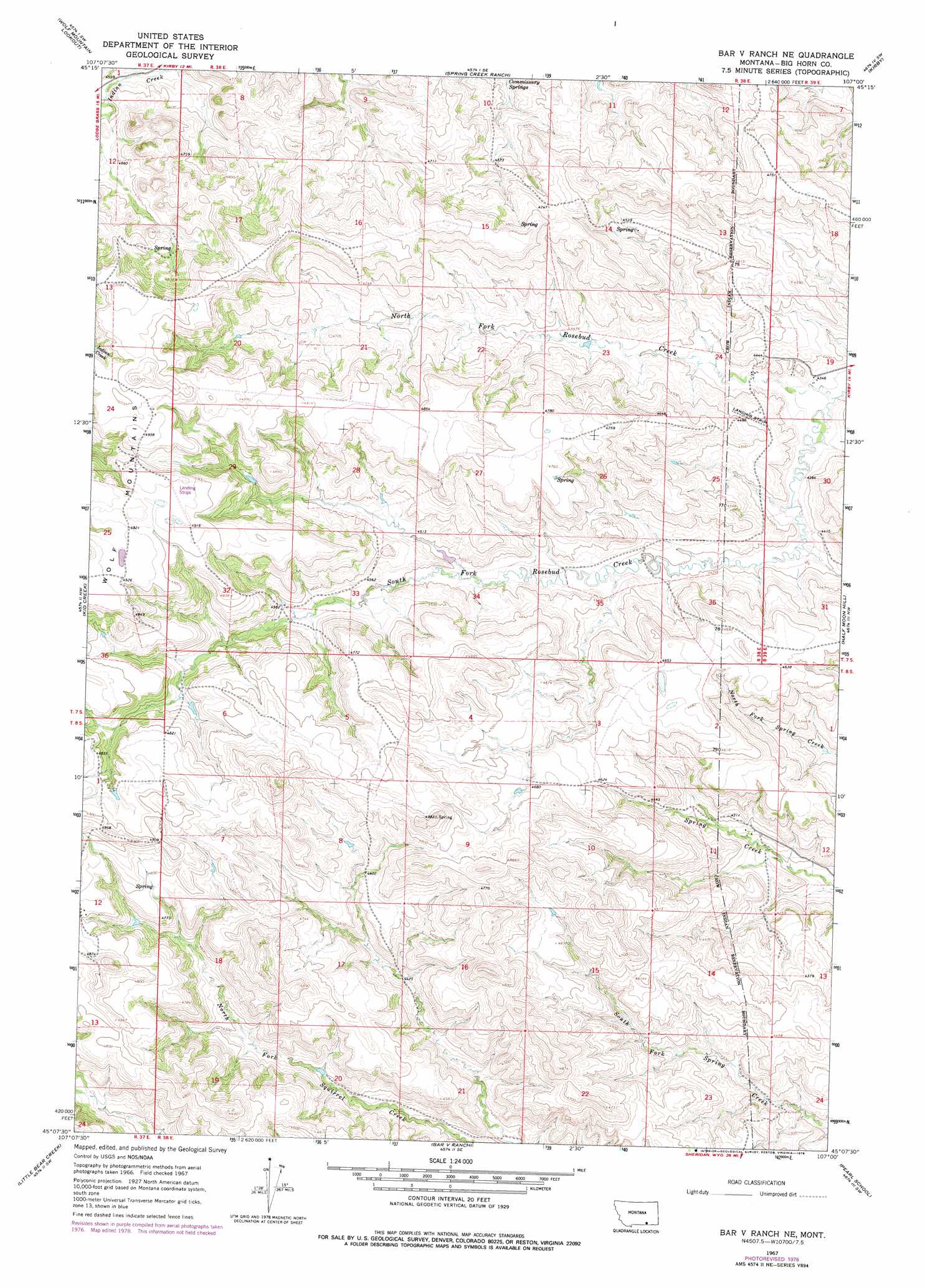
USGS Topo Quad 45107b1 - 1:24,000 scale
| Topo Map Name: | Bar V Ranch Ne |
| USGS Topo Quad ID: | 45107b1 |
| Print Size: | ca. 21 1/4" wide x 27" high |
| Southeast Coordinates: | 45.125° N latitude / 107° W longitude |
| Map Center Coordinates: | 45.1875° N latitude / 107.0625° W longitude |
| U.S. State: | MT |
| Filename: | o45107b1.jpg |
| Download Map JPG Image: | Bar V Ranch Ne topo map 1:24,000 scale |
| Map Type: | Topographic |
| Topo Series: | 7.5´ |
| Map Scale: | 1:24,000 |
| Source of Map Images: | United States Geological Survey (USGS) |
| Alternate Map Versions: |
Bar V Ranch NE MT 1967, updated 1971 Download PDF Buy paper map Bar V Ranch NE MT 1967, updated 1978 Download PDF Buy paper map Bar V Ranch NE MT 2011 Download PDF Buy paper map Bar V Ranch NE MT 2014 Download PDF Buy paper map |
1:24,000 Topo Quads surrounding Bar V Ranch Ne
Lodge Grass Ne |
Thompson Creek Nw |
Thompson Creek |
Birdseye Spring |
Bull Creek Lookout |
Lodge Grass |
Wolf Mountain Lookout |
Spring Creek Ranch |
Kirby |
Taintor Desert |
Wyola Ne |
Kid Creek |
Bar V Ranch Ne |
Half Moon Hill |
Tongue River Dam |
Pass Creek East |
Little Bear Creek |
Bar V Ranch |
Pearl School |
Decker |
Dayton North |
Ranchester |
Monarch |
Acme |
Bar N Draw |
> Back to 45107a1 at 1:100,000 scale
> Back to 45106a1 at 1:250,000 scale
> Back to U.S. Topo Maps home
Bar V Ranch Ne topo map: Gazetteer
Bar V Ranch Ne: Springs
07S38E12DCA_01 Spring elevation 1389m 4557′07S38E14ACDD01 Spring elevation 1374m 4507′
07S38E24DADB01 Spring elevation 1326m 4350′
07S38E24DADB02 Spring elevation 1327m 4353′
07S38E24DBD_02 Spring elevation 1327m 4353′
07S39E07BDB_01 Spring elevation 1330m 4363′
07S39E19DCB_01 Spring elevation 1316m 4317′
08S38E01CCDB01 Spring elevation 1342m 4402′
08S38E02CCBA01 Spring elevation 1344m 4409′
08S38E11ADBC01 Spring elevation 1303m 4274′
08S38E12CBBC01 Spring elevation 1280m 4199′
Bar V Ranch Ne: Streams
North Fork Rosebud Creek elevation 1315m 4314′South Fork Rosebud Creek elevation 1317m 4320′
Bar V Ranch Ne: Wells
07S38E24DBD_01 Well elevation 1329m 4360′07S39E19CAD_01 Well elevation 1326m 4350′
07S39E19CBD_01 Well elevation 1332m 4370′
07S39E31ABBB01 Well elevation 1349m 4425′
08S38E11ADBD01 Well elevation 1302m 4271′
08S38E17DADD01 Well elevation 1374m 4507′
08S38E17DADD02 Well elevation 1374m 4507′
Bar V Ranch Ne digital topo map on disk
Buy this Bar V Ranch Ne topo map showing relief, roads, GPS coordinates and other geographical features, as a high-resolution digital map file on DVD:
Eastern Montana & Western North Dakota
Buy digital topo maps: Eastern Montana & Western North Dakota