Frazee Topo Map Minnesota
To zoom in, hover over the map of Frazee
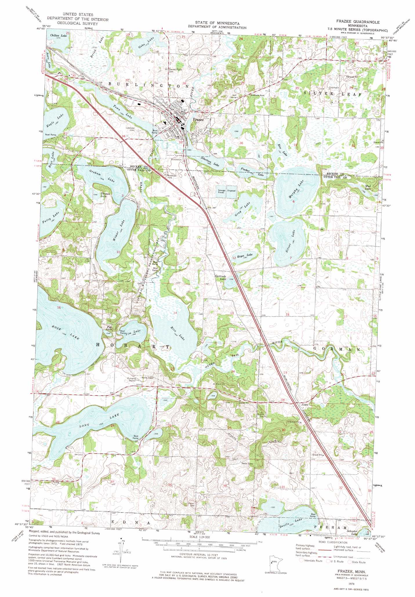
USGS Topo Quad 46095f6 - 1:24,000 scale
| Topo Map Name: | Frazee |
| USGS Topo Quad ID: | 46095f6 |
| Print Size: | ca. 21 1/4" wide x 27" high |
| Southeast Coordinates: | 46.625° N latitude / 95.625° W longitude |
| Map Center Coordinates: | 46.6875° N latitude / 95.6875° W longitude |
| U.S. State: | MN |
| Filename: | o46095f6.jpg |
| Download Map JPG Image: | Frazee topo map 1:24,000 scale |
| Map Type: | Topographic |
| Topo Series: | 7.5´ |
| Map Scale: | 1:24,000 |
| Source of Map Images: | United States Geological Survey (USGS) |
| Alternate Map Versions: |
Frazee MN 1973, updated 1976 Download PDF Buy paper map Frazee MN 2010 Download PDF Buy paper map Frazee MN 2013 Download PDF Buy paper map Frazee MN 2016 Download PDF Buy paper map |
1:24,000 Topo Quads surrounding Frazee
Mount Rainier East |
Richwood |
Flat Lake |
Height Of Land Lake |
Ponsford |
Audubon |
Detroit Lakes |
Rochert |
Toad Mountain |
Evergreen |
Lake Franklin |
Vergas |
Frazee |
Little Pine Lake |
New York Mills Nw |
Lake Lida |
Star Lake |
Dent |
Perham |
New York Mills West |
Heilberger Lake |
Phelps |
Walker Lake |
Ottertail |
Heinola |
> Back to 46095e1 at 1:100,000 scale
> Back to 46094a1 at 1:250,000 scale
> Back to U.S. Topo Maps home
Frazee topo map: Gazetteer
Frazee: Dams
Acorn Lake Dam elevation 420m 1377′Long Lake Dam elevation 444m 1456′
Rose Lake Dam elevation 417m 1368′
Town Lake Dam elevation 415m 1361′
Wimer Lake Dam elevation 411m 1348′
Frazee: Lakes
Albertson Lake elevation 415m 1361′Boot Lake elevation 415m 1361′
Chilton Lake elevation 419m 1374′
Devils Lake elevation 412m 1351′
Fairy Lake elevation 415m 1361′
Fischer Lake elevation 415m 1361′
Gebo Lake elevation 421m 1381′
Gertrude Lake elevation 414m 1358′
Graham Lake elevation 411m 1348′
Gray Lake elevation 416m 1364′
Jim Lake elevation 411m 1348′
Keyes Lake elevation 417m 1368′
Mud Lake elevation 417m 1368′
Murphy Lake elevation 416m 1364′
Pug Lake elevation 411m 1348′
Rice Lake elevation 411m 1348′
Rice Lake elevation 416m 1364′
Rose Lake elevation 411m 1348′
Silver Lake elevation 416m 1364′
Thomas Lake elevation 411m 1348′
Town Lake elevation 415m 1361′
Wimar Lake elevation 411m 1348′
Frazee: Populated Places
Acorn Lake Mobile Home Court elevation 427m 1400′Albertsons Lake Trailer Park elevation 428m 1404′
Feldt Mobile Home Park elevation 424m 1391′
Frazee elevation 423m 1387′
Luce elevation 418m 1371′
Town Lake Estates elevation 423m 1387′
Frazee: Post Offices
Frazee Post Office (historical) elevation 424m 1391′Hobart Post Office (historical) elevation 423m 1387′
Luce Post Office (historical) elevation 418m 1371′
Frazee: Reservoirs
Acorn Lake elevation 420m 1377′Long Lake elevation 444m 1456′
Rose Lake elevation 417m 1368′
Town Lake elevation 415m 1361′
Wimer Lake elevation 411m 1348′
Frazee: Swamps
Brink Lake elevation 420m 1377′Frazee digital topo map on disk
Buy this Frazee topo map showing relief, roads, GPS coordinates and other geographical features, as a high-resolution digital map file on DVD: