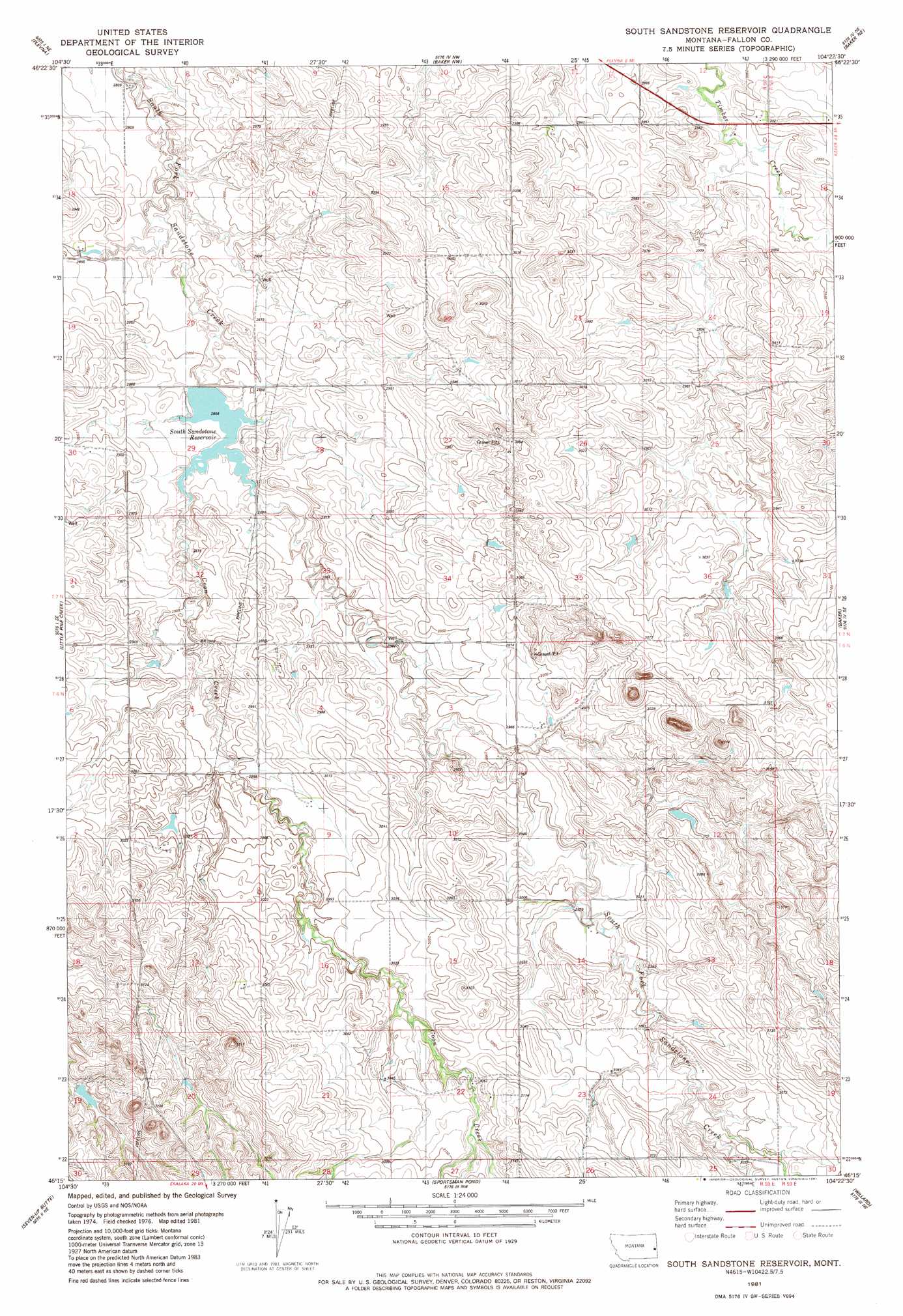
South Sandstone Reservoir Topo Map Montana
To zoom in, hover over the map of South Sandstone Reservoir
USGS Topo Quad 46104c4 - 1:24,000 scale
| Topo Map Name: | South Sandstone Reservoir |
| USGS Topo Quad ID: | 46104c4 |
| Print Size: | ca. 21 1/4" wide x 27" high |
| Southeast Coordinates: | 46.25° N latitude / 104.375° W longitude |
| Map Center Coordinates: | 46.3125° N latitude / 104.4375° W longitude |
| U.S. State: | MT |
| Filename: | o46104c4.jpg |
| Download Map JPG Image: | South Sandstone Reservoir topo map 1:24,000 scale |
| Map Type: | Topographic |
| Topo Series: | 7.5´ |
| Map Scale: | 1:24,000 |
| Source of Map Images: | United States Geological Survey (USGS) |
| Alternate Map Versions: |
South Sandstone Reservoir MT 1981, updated 1981 Download PDF Buy paper map South Sandstone Reservoir MT 2011 Download PDF Buy paper map South Sandstone Reservoir MT 2014 Download PDF Buy paper map |
1:24,000 Topo Quads surrounding South Sandstone Reservoir
Ayer Spring |
Lawrence Creek West |
Lawrence Creek East |
Rush Hall Reservoir |
Shell Butte |
Westmore |
Plevna |
Baker Nw |
Baker Ne |
Morris Butte |
T G Creek |
Little Pine Creek |
South Sandstone Reservoir |
Baker |
Buffalo Reservoir |
Harmon Butte |
Seven-Up Butte |
Sportsman Pond |
Willard |
Webster Nw |
Piney Butte Sw |
Piney Butte |
Medicine Rocks State Park |
Willard Se |
Webster |
> Back to 46104a1 at 1:100,000 scale
> Back to 46104a1 at 1:250,000 scale
> Back to U.S. Topo Maps home
South Sandstone Reservoir topo map: Gazetteer
South Sandstone Reservoir: Dams
Ehret Number 1 Dam elevation 916m 3005′R Maier Dam elevation 866m 2841′
South Sandstone Creek Dam elevation 881m 2890′
South Sandstone Reservoir: Reservoirs
South Sandstone Reservoir elevation 870m 2854′South Sandstone Reservoir: Streams
Coon Creek elevation 868m 2847′South Sandstone Reservoir: Wells
06N58E04BB__01 Well elevation 904m 2965′06N58E04BD__01 Well elevation 909m 2982′
06N58E05BA__01 Well elevation 892m 2926′
06N58E06AC__01 Well elevation 905m 2969′
06N58E10DC__01 Well elevation 926m 3038′
06N58E14ABCD01 Well elevation 909m 2982′
06N58E15CC__01 Well elevation 924m 3031′
06N58E24BDAC01 Well elevation 926m 3038′
06N58E25AA__01 Well elevation 932m 3057′
06N58E25AA__02 Well elevation 937m 3074′
07N58E13AB__01 Well elevation 880m 2887′
07N58E13AC__01 Well elevation 884m 2900′
07N58E18DD__01 Well elevation 873m 2864′
07N58E32AA__01 Well elevation 887m 2910′
07N58E32AA__02 Well elevation 887m 2910′
07N58E33DC__01 Well elevation 885m 2903′
07N59E24DCBB01 Well elevation 906m 2972′
07N59E31BC__01 Well elevation 937m 3074′
South Sandstone Reservoir digital topo map on disk
Buy this South Sandstone Reservoir topo map showing relief, roads, GPS coordinates and other geographical features, as a high-resolution digital map file on DVD:
Eastern Montana & Western North Dakota
Buy digital topo maps: Eastern Montana & Western North Dakota