Plevna Topo Map Montana
To zoom in, hover over the map of Plevna
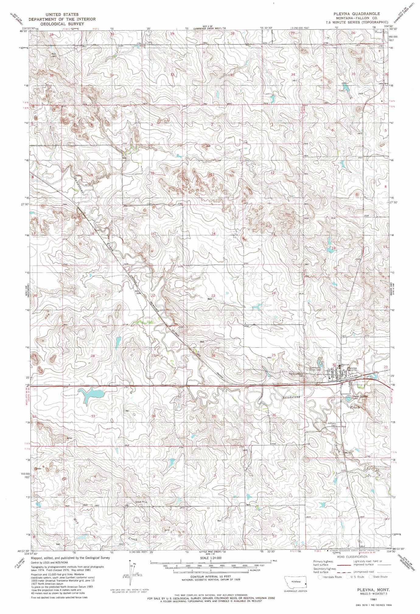
USGS Topo Quad 46104d5 - 1:24,000 scale
| Topo Map Name: | Plevna |
| USGS Topo Quad ID: | 46104d5 |
| Print Size: | ca. 21 1/4" wide x 27" high |
| Southeast Coordinates: | 46.375° N latitude / 104.5° W longitude |
| Map Center Coordinates: | 46.4375° N latitude / 104.5625° W longitude |
| U.S. State: | MT |
| Filename: | o46104d5.jpg |
| Download Map JPG Image: | Plevna topo map 1:24,000 scale |
| Map Type: | Topographic |
| Topo Series: | 7.5´ |
| Map Scale: | 1:24,000 |
| Source of Map Images: | United States Geological Survey (USGS) |
| Alternate Map Versions: |
Plevna MT 1981, updated 1981 Download PDF Buy paper map Plevna MT 2011 Download PDF Buy paper map Plevna MT 2014 Download PDF Buy paper map |
1:24,000 Topo Quads surrounding Plevna
Mildred Ne |
Dorothy Draw |
Ayer Spring Ne |
Rocking Chair Butte |
Cap Rock |
Ismay North |
Ayer Spring |
Lawrence Creek West |
Lawrence Creek East |
Rush Hall Reservoir |
Ismay South |
Westmore |
Plevna |
Baker Nw |
Baker Ne |
Bracket Butte Se |
T G Creek |
Little Pine Creek |
South Sandstone Reservoir |
Baker |
Nelson Butte |
Harmon Butte |
Seven-Up Butte |
Sportsman Pond |
Willard |
> Back to 46104a1 at 1:100,000 scale
> Back to 46104a1 at 1:250,000 scale
> Back to U.S. Topo Maps home
Plevna topo map: Gazetteer
Plevna: Parks
Plevna City Park elevation 851m 2791′Plevna: Populated Places
Plevna elevation 856m 2808′Plevna: Post Offices
Plevna Post Office elevation 855m 2805′Plevna: Streams
South Fork Sandstone Creek elevation 846m 2775′Plevna: Wells
07N57E10BC__01 Well elevation 891m 2923′07N57E10BC__02 Well elevation 897m 2942′
08N57E10CC__01 Well elevation 879m 2883′
08N57E12BA__01 Well elevation 849m 2785′
08N57E14D___01 Well elevation 848m 2782′
08N57E14DA__01 Well elevation 877m 2877′
08N57E14DAD_02 Well elevation 853m 2798′
08N57E23CAAA01 Well elevation 835m 2739′
08N57E23DB__01 Well elevation 831m 2726′
08N58E30ADCA01 Well elevation 863m 2831′
08N58E30BD__01 Well elevation 855m 2805′
08N58E30DBBD01 Well elevation 857m 2811′
08N58E30DD__01 Well elevation 847m 2778′
08N58E31AA__01 Well elevation 842m 2762′
09N56E36ABB_01 Well elevation 871m 2857′
09N57E28CDDC01 Well elevation 854m 2801′
09N57E31AB__01 Well elevation 859m 2818′
Plevna digital topo map on disk
Buy this Plevna topo map showing relief, roads, GPS coordinates and other geographical features, as a high-resolution digital map file on DVD:
Eastern Montana & Western North Dakota
Buy digital topo maps: Eastern Montana & Western North Dakota