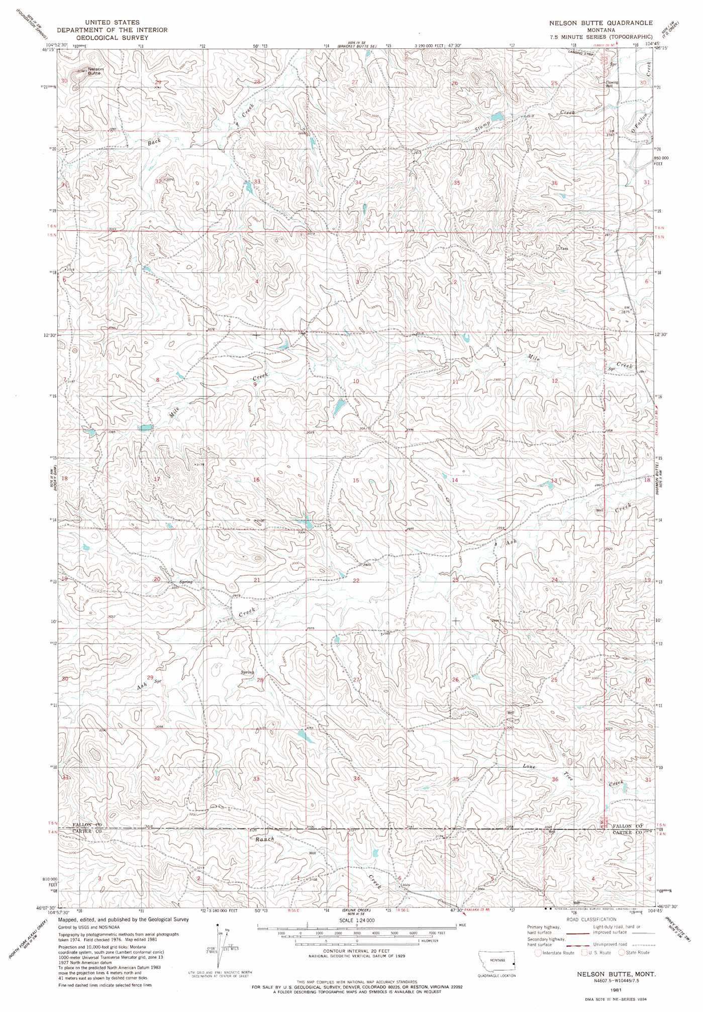
Nelson Butte Topo Map Montana
To zoom in, hover over the map of Nelson Butte
USGS Topo Quad 46104b7 - 1:24,000 scale
| Topo Map Name: | Nelson Butte |
| USGS Topo Quad ID: | 46104b7 |
| Print Size: | ca. 21 1/4" wide x 27" high |
| Southeast Coordinates: | 46.125° N latitude / 104.75° W longitude |
| Map Center Coordinates: | 46.1875° N latitude / 104.8125° W longitude |
| U.S. State: | MT |
| Filename: | o46104b7.jpg |
| Download Map JPG Image: | Nelson Butte topo map 1:24,000 scale |
| Map Type: | Topographic |
| Topo Series: | 7.5´ |
| Map Scale: | 1:24,000 |
| Source of Map Images: | United States Geological Survey (USGS) |
| Alternate Map Versions: |
Nelson Butte MT 1981, updated 1981 Download PDF Buy paper map Nelson Butte MT 2011 Download PDF Buy paper map Nelson Butte MT 2014 Download PDF Buy paper map |
1:24,000 Topo Quads surrounding Nelson Butte
Montague Butte |
Bracket Butte |
Ismay South |
Westmore |
Plevna |
Knowlton |
Foundation Spring |
Bracket Butte Se |
T G Creek |
Little Pine Creek |
Tepee Butte Ne |
Hooky Dam |
Nelson Butte |
Harmon Butte |
Seven-Up Butte |
Tepee Butte |
North Fork Alkali Creek |
Skunk Creek |
Piney Butte Sw |
Piney Butte |
Mills Creek East |
Blacktail Creek Nw |
Board Corral Creek |
Beaver Flats North |
Ekalaka |
> Back to 46104a1 at 1:100,000 scale
> Back to 46104a1 at 1:250,000 scale
> Back to U.S. Topo Maps home
Nelson Butte topo map: Gazetteer
Nelson Butte: Streams
Stump Creek elevation 842m 2762′Nelson Butte: Summits
Nelson Butte elevation 952m 3123′Nelson Butte: Wells
04N55E04DAA_01 Well elevation 973m 3192′05N55E11AC__01 Well elevation 878m 2880′
05N55E13CC__01 Well elevation 885m 2903′
05N55E13DAD_01 Well elevation 871m 2857′
05N55E18CDC_01 Well elevation 931m 3054′
05N55E21CCCC01 Well elevation 912m 2992′
05N55E23AADB01 Well elevation 883m 2896′
05N55E23BD__01 Well elevation 889m 2916′
05N55E27BD__01 Well elevation 922m 3024′
05N55E35ADAD01 Well elevation 914m 2998′
05N56E07BBC_01 Well elevation 874m 2867′
06N55E26BBBB01 Well elevation 892m 2926′
06N56E31BC__01 Well elevation 860m 2821′
06N56E31CC__01 Well elevation 867m 2844′
Nelson Butte digital topo map on disk
Buy this Nelson Butte topo map showing relief, roads, GPS coordinates and other geographical features, as a high-resolution digital map file on DVD:
Eastern Montana & Western North Dakota
Buy digital topo maps: Eastern Montana & Western North Dakota