Cotttonwood Reservoir Topo Map Montana
To zoom in, hover over the map of Cotttonwood Reservoir
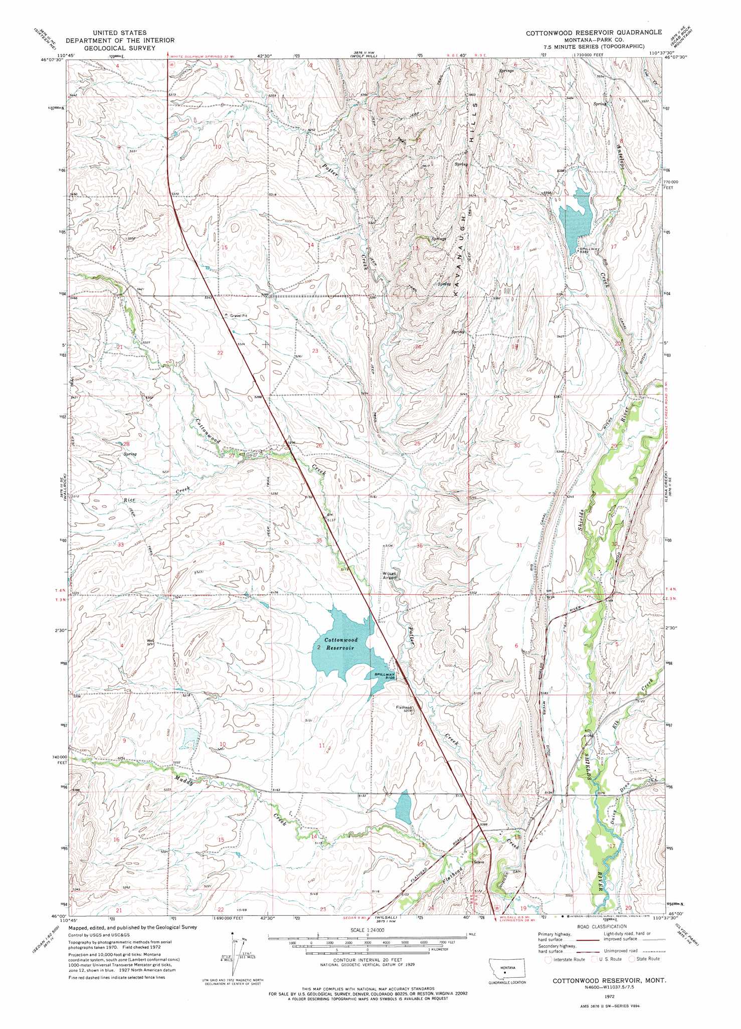
USGS Topo Quad 46110a6 - 1:24,000 scale
| Topo Map Name: | Cotttonwood Reservoir |
| USGS Topo Quad ID: | 46110a6 |
| Print Size: | ca. 21 1/4" wide x 27" high |
| Southeast Coordinates: | 46° N latitude / 110.625° W longitude |
| Map Center Coordinates: | 46.0625° N latitude / 110.6875° W longitude |
| U.S. State: | MT |
| Filename: | o46110a6.jpg |
| Download Map JPG Image: | Cotttonwood Reservoir topo map 1:24,000 scale |
| Map Type: | Topographic |
| Topo Series: | 7.5´ |
| Map Scale: | 1:24,000 |
| Source of Map Images: | United States Geological Survey (USGS) |
| Alternate Map Versions: |
Cottonwood Reservoir MT 1972, updated 1975 Download PDF Buy paper map Cottonwood Reservoir MT 2011 Download PDF Buy paper map Cottonwood Reservoir MT 2014 Download PDF Buy paper map |
1:24,000 Topo Quads surrounding Cotttonwood Reservoir
Black Butte Mountain |
Ringling |
Hamen |
Rimrock Divide |
Lebo |
Sixteen |
Sixteen Ne |
Wolf Hill |
Scab Rock Mountain |
Virginia Peak |
Hatfield Mountain |
Wallrock |
Cotttonwood Reservoir |
Lena Creek |
Campfire Lake |
Sacagawea Peak |
Sedan |
Wilsall |
Clyde Park |
Ibex Mountain |
Saddle Peak |
Grassy Mountain |
Gobblers Knob |
Chadborn |
Grannis |
> Back to 46110a1 at 1:100,000 scale
> Back to 46110a1 at 1:250,000 scale
> Back to U.S. Topo Maps home
Cotttonwood Reservoir topo map: Gazetteer
Cotttonwood Reservoir: Airports
Wilsall Airport elevation 1564m 5131′Cotttonwood Reservoir: Canals
Big Canal elevation 1641m 5383′Myers Ditch elevation 1613m 5291′
Sheilds Canyon elevation 1528m 5013′
Cotttonwood Reservoir: Dams
Cottonwood Dam elevation 1556m 5104′Jordan Dam elevation 1642m 5387′
Kaiser Dam elevation 1552m 5091′
Landers Number 1 Dam elevation 1598m 5242′
Cotttonwood Reservoir: Populated Places
Meyersburg (historical) elevation 1537m 5042′Cotttonwood Reservoir: Post Offices
Meyersburg Post Office (historical) elevation 1537m 5042′Cotttonwood Reservoir: Reservoirs
Cottonwood Reservoir elevation 1556m 5104′Cotttonwood Reservoir: Streams
Antelope Creek elevation 1598m 5242′Cottonwood Creek elevation 1549m 5082′
Daisy Dean Creek elevation 1542m 5059′
Elk Creek elevation 1550m 5085′
Muddy Creek elevation 1539m 5049′
Potter Creek elevation 1535m 5036′
Rice Creek elevation 1586m 5203′
Cotttonwood Reservoir: Summits
Kavanaugh Hills elevation 1734m 5688′Cotttonwood Reservoir: Wells
03N08E04A___01 Well elevation 1620m 5314′03N08E10C___01 Well elevation 1588m 5209′
03N09E07B___01 Well elevation 1612m 5288′
03N09E08C___01 Well elevation 1554m 5098′
03N09E08D___01 Well elevation 1570m 5150′
04N08E09A___01 Well elevation 1622m 5321′
04N08E27A___01 Well elevation 1605m 5265′
04N09E31B___01 Well elevation 1628m 5341′
04N09E32C___01 Well elevation 1575m 5167′
Cotttonwood Reservoir digital topo map on disk
Buy this Cotttonwood Reservoir topo map showing relief, roads, GPS coordinates and other geographical features, as a high-resolution digital map file on DVD: