Wilson Park Topo Map Montana
To zoom in, hover over the map of Wilson Park
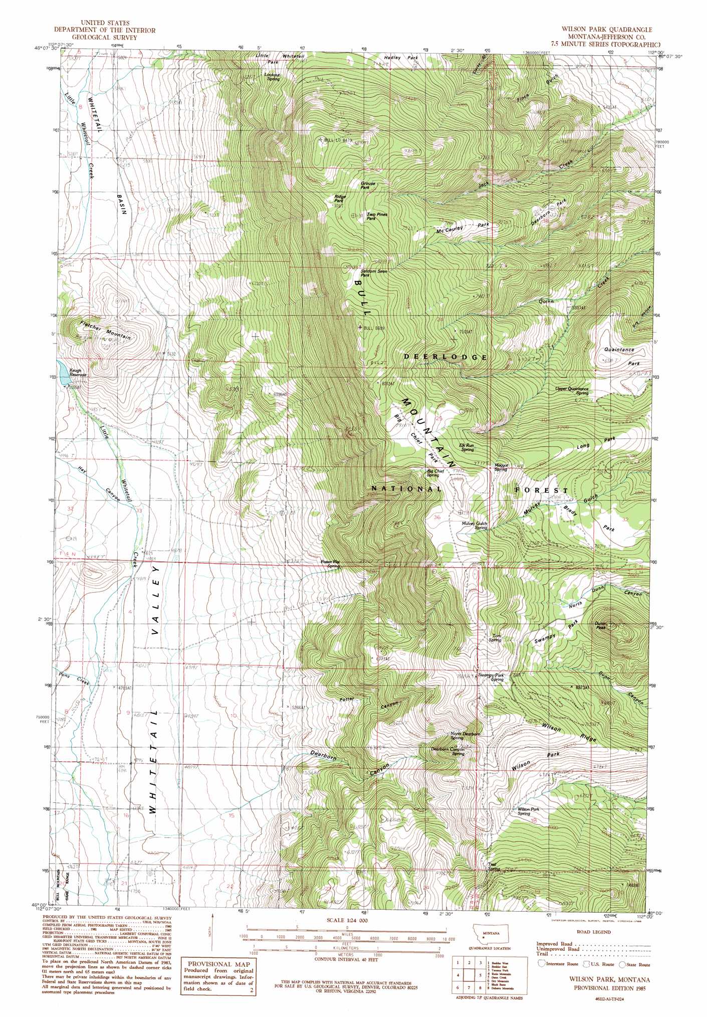
USGS Topo Quad 46112a1 - 1:24,000 scale
| Topo Map Name: | Wilson Park |
| USGS Topo Quad ID: | 46112a1 |
| Print Size: | ca. 21 1/4" wide x 27" high |
| Southeast Coordinates: | 46° N latitude / 112° W longitude |
| Map Center Coordinates: | 46.0625° N latitude / 112.0625° W longitude |
| U.S. State: | MT |
| Filename: | o46112a1.jpg |
| Download Map JPG Image: | Wilson Park topo map 1:24,000 scale |
| Map Type: | Topographic |
| Topo Series: | 7.5´ |
| Map Scale: | 1:24,000 |
| Source of Map Images: | United States Geological Survey (USGS) |
| Alternate Map Versions: |
Wilson Park MT 1985, updated 1986 Download PDF Buy paper map Wilson Park MT 1996, updated 1998 Download PDF Buy paper map Wilson Park MT 2011 Download PDF Buy paper map Wilson Park MT 2014 Download PDF Buy paper map |
| FStopo: | US Forest Service topo Wilson Park is available: Download FStopo PDF Download FStopo TIF |
1:24,000 Topo Quads surrounding Wilson Park
Basin |
Mount Thompson |
Wickes |
Elkhorn |
Crow Creek Falls |
Bison Canyon |
Boulder West |
Boulder East |
Tacoma Park |
Devils Fence |
Whitetail Peak |
Ratio Mountain |
Wilson Park |
Dunn Creek |
Willow Springs |
Delmoe Lake |
Dry Mountain |
Black Butte |
Doherty Mountain |
Negro Hollow |
Grace |
Vendome |
Whitehall |
Jefferson Island |
Sappington |
> Back to 46112a1 at 1:100,000 scale
> Back to 46112a1 at 1:250,000 scale
> Back to U.S. Topo Maps home
Wilson Park topo map: Gazetteer
Wilson Park: Basins
Whitetail Basin elevation 1586m 5203′Wilson Park: Dams
Keogh Dam elevation 1531m 5022′Moulton Creek Dam Number 1 elevation 1924m 6312′
Wilson Park: Flats
Big Chief Park elevation 2399m 7870′Brady Park elevation 2282m 7486′
Deerhorn Park elevation 2033m 6669′
Grouse Park elevation 2407m 7896′
Little Whitetail Park elevation 2137m 7011′
Long Park elevation 2185m 7168′
McCauley Park elevation 2242m 7355′
Quaintance Park elevation 2107m 6912′
Ridge Park elevation 2456m 8057′
Seldom Seen Park elevation 2544m 8346′
Swampy Park elevation 2272m 7454′
Two Pines Park elevation 2358m 7736′
Wilson Park elevation 2138m 7014′
Wilson Park: Mines
Nettie Mine elevation 1706m 5597′Wilson Park: Populated Places
Valley (historical) elevation 1449m 4753′Wilson Park: Reservoirs
Keogh Reservoir elevation 1531m 5022′Moulton Reservoir elevation 1924m 6312′
Wilson Park: Ridges
Bull Mountain elevation 2618m 8589′Wilson Ridge elevation 2188m 7178′
Wilson Park: Springs
Big Chief Spring elevation 2391m 7844′Dearborn Canyon Spring elevation 2197m 7208′
Elk Run Spring elevation 2320m 7611′
Lookout Spring elevation 2158m 7080′
Maggot Spring elevation 2354m 7723′
Mulvey Gulch Spring elevation 2320m 7611′
North Dearborn Spring elevation 2101m 6893′
Potter Flat Spring elevation 1794m 5885′
Swampy Park Spring elevation 2226m 7303′
Tom Spring elevation 2290m 7513′
Trail Spring elevation 2239m 7345′
Upper Quaintance Spring elevation 2038m 6686′
Wilson Park Spring elevation 2113m 6932′
Wilson Park: Streams
Dearborn Creek elevation 1494m 4901′Pony Creek elevation 1451m 4760′
Potter Creek elevation 1492m 4895′
Wilson Park: Summits
Dunn Peak elevation 2289m 7509′Fletcher Mountain elevation 1732m 5682′
Wilson Park: Trails
Fetters Trail elevation 2048m 6719′Wilson Park: Valleys
Dearborn Canyon elevation 1437m 4714′Finch Gulch elevation 1623m 5324′
Potter Canyon elevation 1501m 4924′
Whitetail Valley elevation 1531m 5022′
Wilson Park: Wells
03N04W21ABDB01 Well elevation 1457m 4780′Wilson Park digital topo map on disk
Buy this Wilson Park topo map showing relief, roads, GPS coordinates and other geographical features, as a high-resolution digital map file on DVD: