Doherty Mountain Topo Map Montana
To zoom in, hover over the map of Doherty Mountain
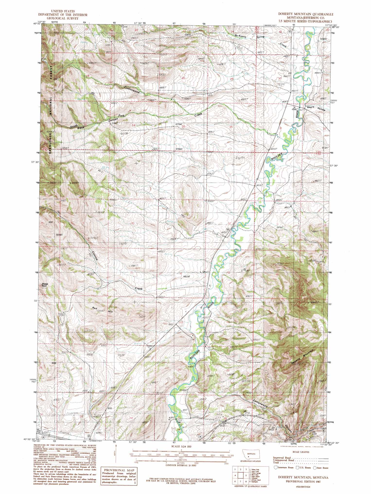
USGS Topo Quad 45111h8 - 1:24,000 scale
| Topo Map Name: | Doherty Mountain |
| USGS Topo Quad ID: | 45111h8 |
| Print Size: | ca. 21 1/4" wide x 27" high |
| Southeast Coordinates: | 45.875° N latitude / 111.875° W longitude |
| Map Center Coordinates: | 45.9375° N latitude / 111.9375° W longitude |
| U.S. State: | MT |
| Filename: | o45111h8.jpg |
| Download Map JPG Image: | Doherty Mountain topo map 1:24,000 scale |
| Map Type: | Topographic |
| Topo Series: | 7.5´ |
| Map Scale: | 1:24,000 |
| Source of Map Images: | United States Geological Survey (USGS) |
| Alternate Map Versions: |
Doherty Mountain MT 1987, updated 1988 Download PDF Buy paper map Doherty Mountain MT 1996, updated 1998 Download PDF Buy paper map Doherty Mountain MT 2011 Download PDF Buy paper map Doherty Mountain MT 2014 Download PDF Buy paper map |
| FStopo: | US Forest Service topo Doherty Mountain is available: Download FStopo PDF Download FStopo TIF |
1:24,000 Topo Quads surrounding Doherty Mountain
Boulder West |
Boulder East |
Tacoma Park |
Devils Fence |
Radersburg |
Ratio Mountain |
Wilson Park |
Dunn Creek |
Willow Springs |
Radersburg Sw |
Dry Mountain |
Black Butte |
Doherty Mountain |
Negro Hollow |
Milligan Canyon |
Vendome |
Whitehall |
Jefferson Island |
Sappington |
Willow Creek |
Waterloo |
Manhead Mountain |
Pony |
Harrison |
Willow Creek Reservoir |
> Back to 45111e1 at 1:100,000 scale
> Back to 45110a1 at 1:250,000 scale
> Back to U.S. Topo Maps home
Doherty Mountain topo map: Gazetteer
Doherty Mountain: Mines
Frisbe Mine elevation 1554m 5098′Shafthouse Hill Mine elevation 1443m 4734′
Doherty Mountain: Post Offices
Cold Spring Post Office (historical) elevation 1345m 4412′Doherty Mountain: Streams
Conrow Creek elevation 1323m 4340′Cottonwood Creek elevation 1340m 4396′
McKanna Spring Creek elevation 1348m 4422′
South Fork Cottonwood Creek elevation 1421m 4662′
Doherty Mountain: Summits
Doherty Mountain elevation 1606m 5269′Red Hill elevation 1556m 5104′
Doherty Mountain: Valleys
Black Canyon elevation 1435m 4708′Cottonwood Canyon elevation 1348m 4422′
Doherty Mountain: Wells
02N03W12CACD01 Well elevation 1342m 4402′02N03W12CADC01 Well elevation 1341m 4399′
02N03W15CBC_01 Well elevation 1446m 4744′
02N03W22DCDD01 Well elevation 1379m 4524′
02N03W23DDBD01 Well elevation 1346m 4416′
03N02W29CDBC01 Well elevation 1359m 4458′
Doherty Mountain digital topo map on disk
Buy this Doherty Mountain topo map showing relief, roads, GPS coordinates and other geographical features, as a high-resolution digital map file on DVD: