Whitehall Topo Map Montana
To zoom in, hover over the map of Whitehall
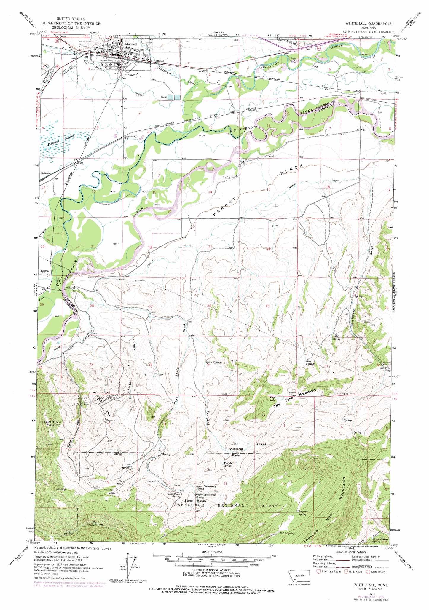
USGS Topo Quad 45112g1 - 1:24,000 scale
| Topo Map Name: | Whitehall |
| USGS Topo Quad ID: | 45112g1 |
| Print Size: | ca. 21 1/4" wide x 27" high |
| Southeast Coordinates: | 45.75° N latitude / 112° W longitude |
| Map Center Coordinates: | 45.8125° N latitude / 112.0625° W longitude |
| U.S. State: | MT |
| Filename: | o45112g1.jpg |
| Download Map JPG Image: | Whitehall topo map 1:24,000 scale |
| Map Type: | Topographic |
| Topo Series: | 7.5´ |
| Map Scale: | 1:24,000 |
| Source of Map Images: | United States Geological Survey (USGS) |
| Alternate Map Versions: |
Whitehall MT 1963, updated 1965 Download PDF Buy paper map Whitehall MT 1963, updated 1978 Download PDF Buy paper map Whitehall MT 1996, updated 1998 Download PDF Buy paper map Whitehall MT 2011 Download PDF Buy paper map Whitehall MT 2014 Download PDF Buy paper map |
| FStopo: | US Forest Service topo Whitehall is available: Download FStopo PDF Download FStopo TIF |
1:24,000 Topo Quads surrounding Whitehall
Whitetail Peak |
Ratio Mountain |
Wilson Park |
Dunn Creek |
Willow Springs |
Delmoe Lake |
Dry Mountain |
Black Butte |
Doherty Mountain |
Negro Hollow |
Grace |
Vendome |
Whitehall |
Jefferson Island |
Sappington |
Silver Star |
Waterloo |
Manhead Mountain |
Pony |
Harrison |
Twin Bridges |
Old Baldy Mountain |
Noble Peak |
Potosi Peak |
Maltbys Mound |
> Back to 45112e1 at 1:100,000 scale
> Back to 45112a1 at 1:250,000 scale
> Back to U.S. Topo Maps home
Whitehall topo map: Gazetteer
Whitehall: Basins
Bone Basin elevation 1738m 5702′Whestphal Basin elevation 1639m 5377′
Whitehall: Benches
Parrot Bench elevation 1340m 4396′Whitehall: Bridges
Kountz Bridge elevation 1319m 4327′Mayflower Bridge elevation 1312m 4304′
Whitehall: Lakes
Dry Lake elevation 1818m 5964′Whitehall: Mines
Mayflower Mine elevation 1601m 5252′NE SW Section 9 Mine elevation 1813m 5948′
NW SE Section 31 Mine elevation 1676m 5498′
NW SW Section 34 Mine elevation 1494m 4901′
Perry Canyon Mine elevation 1630m 5347′
SE NW Section 4 Mine elevation 1842m 6043′
SE SW Section 3 Mine elevation 1550m 5085′
SE SW Section 5 Mine elevation 1605m 5265′
SW SE Section 30 Mine elevation 1574m 5164′
SW SW Section 29 Mine elevation 1573m 5160′
West Mayflower Mine elevation 1636m 5367′
Whitehall: Populated Places
La Casa Trailer Park elevation 1329m 4360′Rice Motel and Trailer Court elevation 1328m 4356′
Whitehall elevation 1329m 4360′
Whitehall: Post Offices
Whitehall Post Office elevation 1329m 4360′Whitehall: Springs
Bone Basin Spring elevation 1653m 5423′Creek Bottom Spring elevation 1788m 5866′
Era Spring elevation 2039m 6689′
Guymon Spring elevation 2018m 6620′
Lower Gooseberry Spring elevation 1685m 5528′
Mud Spring elevation 1612m 5288′
Splan Springs elevation 1464m 4803′
Upper Gooseberry Spring elevation 1711m 5613′
Westphal Spring elevation 1668m 5472′
Whitehall: Streams
Big Pipestone Creek elevation 1321m 4333′Bone Basin Creek elevation 1337m 4386′
Fish Creek elevation 1318m 4324′
Mayflower Creek elevation 1312m 4304′
Whestphal Creek elevation 1424m 4671′
Whitetail Deer Creek elevation 1320m 4330′
Whitehall: Summits
Dry Lake Mountains elevation 1836m 6023′Gold Hill elevation 1712m 5616′
Point of Rocks elevation 1820m 5971′
Whitehall: Valleys
Dixon Gulch elevation 1388m 4553′Gold Hill Gulch elevation 1390m 4560′
Mayflower Gulch elevation 1363m 4471′
Pole Canyon elevation 1783m 5849′
Whitehall: Wells
01N03W17ABDA01 Well elevation 1342m 4402′01N04W03BADD01 Well elevation 1326m 4350′
01N04W04ABBA01 Well elevation 1335m 4379′
01N04W04ACCD01 Well elevation 1329m 4360′
01N04W04ADDA01 Well elevation 1328m 4356′
02N04W28CDCB01 Well elevation 1359m 4458′
Whitehall digital topo map on disk
Buy this Whitehall topo map showing relief, roads, GPS coordinates and other geographical features, as a high-resolution digital map file on DVD: