Bison Mountain Topo Map Montana
To zoom in, hover over the map of Bison Mountain
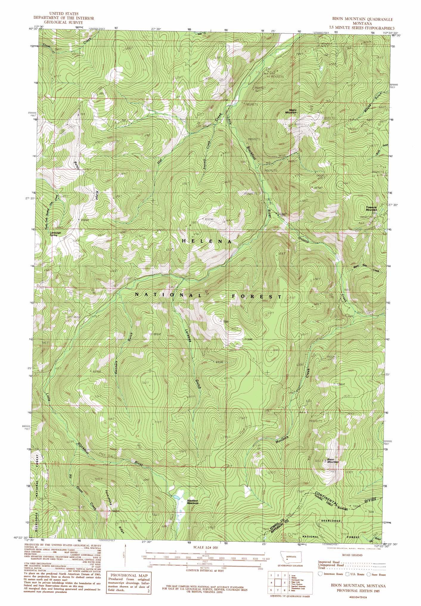
USGS Topo Quad 46112d4 - 1:24,000 scale
| Topo Map Name: | Bison Mountain |
| USGS Topo Quad ID: | 46112d4 |
| Print Size: | ca. 21 1/4" wide x 27" high |
| Southeast Coordinates: | 46.375° N latitude / 112.375° W longitude |
| Map Center Coordinates: | 46.4375° N latitude / 112.4375° W longitude |
| U.S. State: | MT |
| Filename: | o46112d4.jpg |
| Download Map JPG Image: | Bison Mountain topo map 1:24,000 scale |
| Map Type: | Topographic |
| Topo Series: | 7.5´ |
| Map Scale: | 1:24,000 |
| Source of Map Images: | United States Geological Survey (USGS) |
| Alternate Map Versions: |
Bison Mountain MT 1985, updated 1986 Download PDF Buy paper map Bison Mountain MT 2001, updated 2004 Download PDF Buy paper map Bison Mountain MT 2011 Download PDF Buy paper map Bison Mountain MT 2014 Download PDF Buy paper map |
| FStopo: | US Forest Service topo Bison Mountain is available: Download FStopo PDF Download FStopo TIF |
1:24,000 Topo Quads surrounding Bison Mountain
Gravely Mountain |
Ophir Creek |
Esmeralda Hill |
Greenhorn Mountain |
Austin |
Luke Mountain |
Avon |
Elliston |
Macdonald Pass |
Black Mountain |
Deer Lodge |
Baggs Creek |
Bison Mountain |
Three Brothers |
Chessman Reservoir |
Orofino Creek |
Sugarloaf Mountain |
Thunderbolt Creek |
Basin |
Mount Thompson |
Orofino Mountain |
Lockhart Meadows |
Sheepshead Mountain |
Bison Canyon |
Boulder West |
> Back to 46112a1 at 1:100,000 scale
> Back to 46112a1 at 1:250,000 scale
> Back to U.S. Topo Maps home
Bison Mountain topo map: Gazetteer
Bison Mountain: Flats
Blackfoot Meadows elevation 2018m 6620′Bison Mountain: Mines
Big Dick Mine elevation 2044m 6706′Charter Oak Mine elevation 1663m 5456′
Charter Oak Mines elevation 1702m 5583′
Golden Anchor Mine elevation 1727m 5666′
Golden Anchor Mine elevation 2128m 6981′
Julia Mine elevation 2076m 6811′
Julia Mine elevation 2006m 6581′
Kimball Mine elevation 1702m 5583′
Monarch Mill Site elevation 2033m 6669′
Monarch Mine elevation 2040m 6692′
Monarch Mine elevation 2106m 6909′
Mountain View Mine elevation 1959m 6427′
NE NW Section 12 Mine elevation 1733m 5685′
NE NW Section 6 Mine elevation 2133m 6998′
Negros Mine elevation 1711m 5613′
Orphan Widow Mine elevation 1908m 6259′
SE NW Section 12 Mine elevation 1765m 5790′
SE SW Section 8 Mine elevation 2124m 6968′
SW NE Section 12 Mine elevation 1701m 5580′
SW NW Section 20 Mine elevation 1817m 5961′
SW SE Section 1 Mine elevation 1780m 5839′
Viking Mine elevation 1941m 6368′
Bison Mountain: Post Offices
Charlesburg Post Office (historical) elevation 1938m 6358′Bison Mountain: Ridges
Baldy Ridge elevation 2114m 6935′Forbidding Ridge elevation 2238m 7342′
Bison Mountain: Springs
Limburger Spring elevation 2097m 6879′Bison Mountain: Streams
Hat Creek elevation 1655m 5429′Mary Ann Creek elevation 1788m 5866′
Monarch Creek elevation 1802m 5912′
No Grass Creek elevation 1925m 6315′
Ontario Creek elevation 1694m 5557′
Sawmill Creek elevation 1692m 5551′
Bison Mountain: Summits
Bison Mountain elevation 2431m 7975′Irish Mine Hill elevation 2050m 6725′
Negro Mountain elevation 2151m 7057′
Treasure Mountain elevation 2246m 7368′
Bison Mountain: Valleys
Connors Gulch elevation 1851m 6072′Larabee Gulch elevation 1802m 5912′
Bison Mountain digital topo map on disk
Buy this Bison Mountain topo map showing relief, roads, GPS coordinates and other geographical features, as a high-resolution digital map file on DVD: