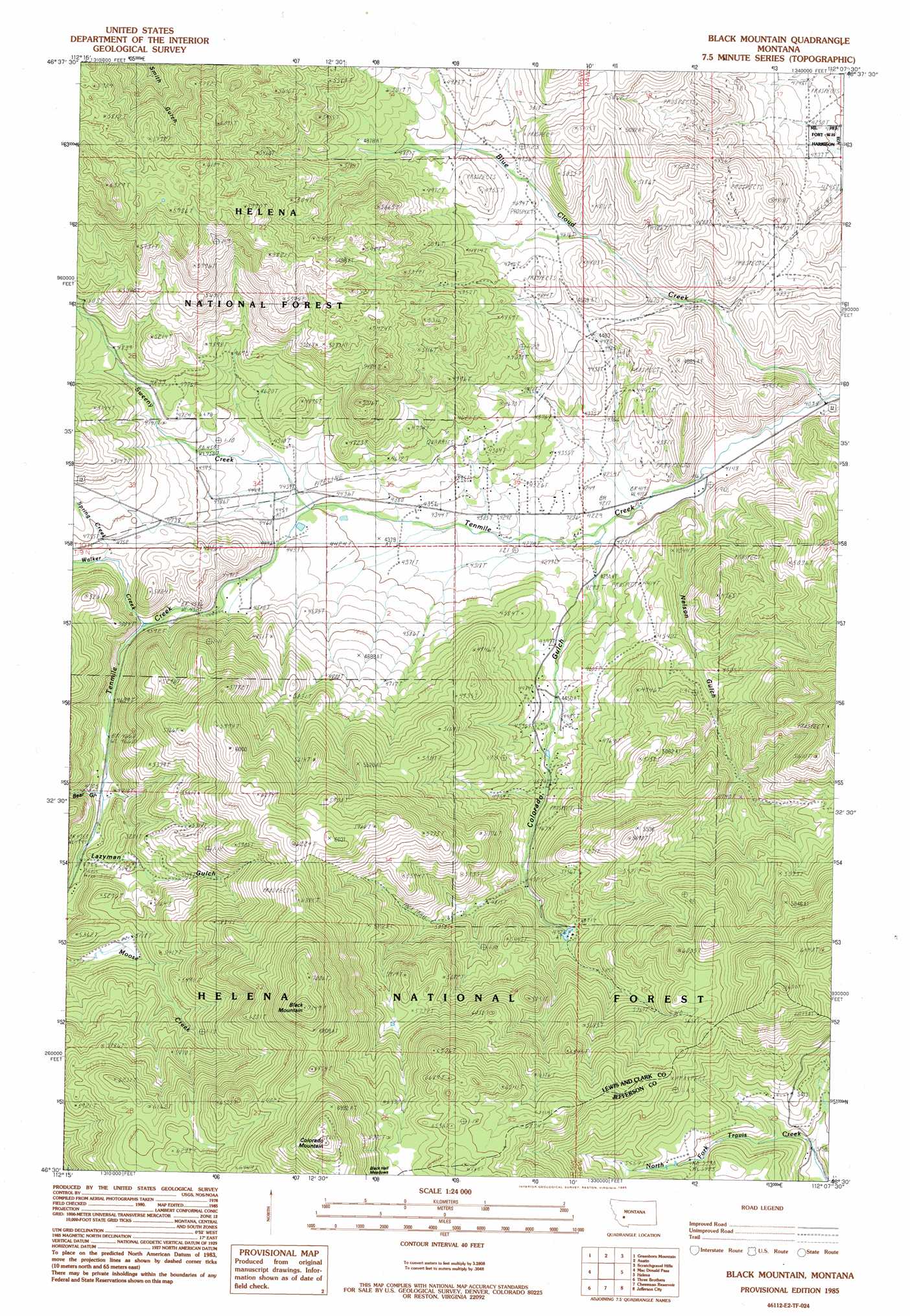
Black Mountain Topo Map Montana
To zoom in, hover over the map of Black Mountain
USGS Topo Quad 46112e2 - 1:24,000 scale
| Topo Map Name: | Black Mountain |
| USGS Topo Quad ID: | 46112e2 |
| Print Size: | ca. 21 1/4" wide x 27" high |
| Southeast Coordinates: | 46.5° N latitude / 112.125° W longitude |
| Map Center Coordinates: | 46.5625° N latitude / 112.1875° W longitude |
| U.S. State: | MT |
| Filename: | o46112e2.jpg |
| Download Map JPG Image: | Black Mountain topo map 1:24,000 scale |
| Map Type: | Topographic |
| Topo Series: | 7.5´ |
| Map Scale: | 1:24,000 |
| Source of Map Images: | United States Geological Survey (USGS) |
| Alternate Map Versions: |
Black Mountain MT 1985, updated 1985 Download PDF Buy paper map Black Mountain MT 2001, updated 2004 Download PDF Buy paper map Black Mountain MT 2011 Download PDF Buy paper map Black Mountain MT 2014 Download PDF Buy paper map |
| FStopo: | US Forest Service topo Black Mountain is available: Download FStopo PDF Download FStopo TIF |
1:24,000 Topo Quads surrounding Black Mountain
Granite Butte |
Canyon Creek |
Silver City |
Rattlesnake Mountain |
Upper Holter Lake |
Esmeralda Hill |
Greenhorn Mountain |
Austin |
Scratchgravel Hill |
Lake Helena |
Elliston |
Macdonald Pass |
Black Mountain |
Helena |
East Helena |
Bison Mountain |
Three Brothers |
Chessman Reservoir |
Jefferson City |
Clancy |
Thunderbolt Creek |
Basin |
Mount Thompson |
Wickes |
Elkhorn |
> Back to 46112e1 at 1:100,000 scale
> Back to 46112a1 at 1:250,000 scale
> Back to U.S. Topo Maps home
Black Mountain topo map: Gazetteer
Black Mountain: Airports
Duncan Airport elevation 1302m 4271′Red Mountain Heliport elevation 1844m 6049′
Ten Mile Airport elevation 1307m 4288′
Black Mountain: Forests
Helena National Forest elevation 1542m 5059′Black Mountain: Mines
Grunenfelder Mine elevation 1347m 4419′Isaak Mine elevation 1322m 4337′
NE NE Section 25 Mine elevation 1385m 4543′
NE SE Section 8 Mine elevation 1731m 5679′
NW SE Section 18 Mine elevation 1451m 4760′
Silver Coin Mine elevation 1470m 4822′
Silver Coin North Mine elevation 1426m 4678′
Stemwinder Mine elevation 1282m 4206′
SW NE Section 31 Mine elevation 1296m 4251′
Black Mountain: Populated Places
Blue Cloud (historical) elevation 1407m 4616′Black Mountain: Post Offices
Baxendale Post Office (historical) elevation 1383m 4537′Black Mountain: Springs
10N04W32BCD_01 Spring elevation 1267m 4156′10N04W32DAD_01 Spring elevation 1444m 4737′
Black Mountain: Streams
Blue Cloud Creek elevation 1244m 4081′Spring Creek elevation 1430m 4691′
Sweeney Creek elevation 1343m 4406′
Walker Creek elevation 1398m 4586′
Willow Creek elevation 1320m 4330′
Black Mountain: Summits
Black Mountain elevation 2175m 7135′Colorado Mountain elevation 2200m 7217′
Black Mountain: Trails
Sweeney Creek Ecology Trail elevation 1549m 5082′Black Mountain: Valleys
Bear Gulch elevation 1441m 4727′Colorado Gulch elevation 1290m 4232′
Lazyman Gulch elevation 1469m 4819′
Nelson Gulch elevation 1276m 4186′
Black Mountain: Wells
09N05W03AACC01 Well elevation 1364m 4475′09N05W03ABCB01 Well elevation 1361m 4465′
09N05W03ADBB01 Well elevation 1360m 4461′
09N05W12ABDA01 Well elevation 1354m 4442′
09N05W12ACAD01 Well elevation 1376m 4514′
09N05W12CCDA01 Well elevation 1468m 4816′
09N05W13ACDB01 Well elevation 1435m 4708′
09N05W16BABB01 Well elevation 1440m 4724′
09N05W21ACBA01 Well elevation 1562m 5124′
10N05W33ABD_01 Well elevation 1448m 4750′
10N05W36CBBB01 Well elevation 1337m 4386′
10N05W36DADD01 Well elevation 1292m 4238′
Black Mountain digital topo map on disk
Buy this Black Mountain topo map showing relief, roads, GPS coordinates and other geographical features, as a high-resolution digital map file on DVD: