Medicine Tree Hill Topo Map Montana
To zoom in, hover over the map of Medicine Tree Hill
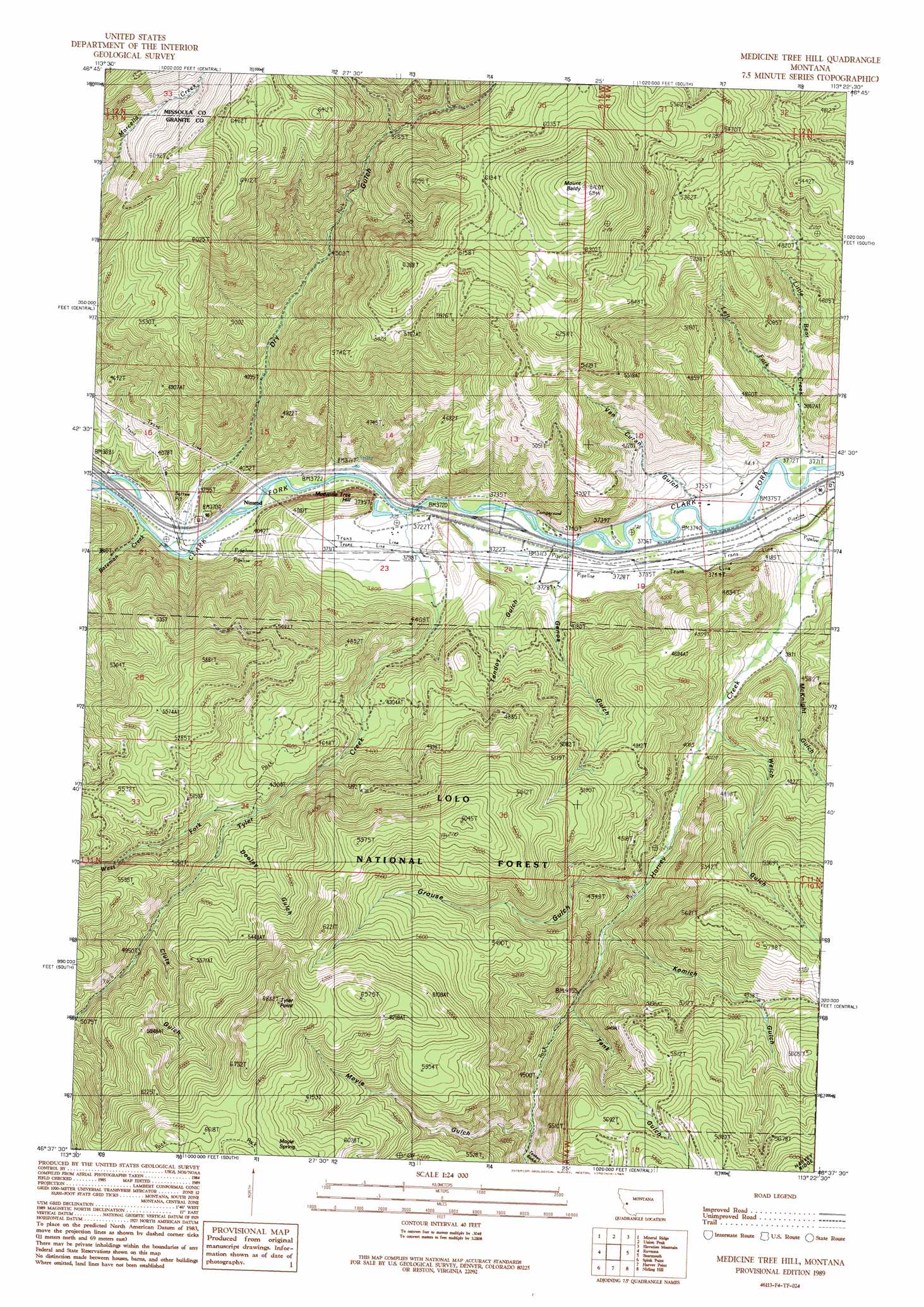
USGS Topo Quad 46113f4 - 1:24,000 scale
| Topo Map Name: | Medicine Tree Hill |
| USGS Topo Quad ID: | 46113f4 |
| Print Size: | ca. 21 1/4" wide x 27" high |
| Southeast Coordinates: | 46.625° N latitude / 113.375° W longitude |
| Map Center Coordinates: | 46.6875° N latitude / 113.4375° W longitude |
| U.S. State: | MT |
| Filename: | o46113f4.jpg |
| Download Map JPG Image: | Medicine Tree Hill topo map 1:24,000 scale |
| Map Type: | Topographic |
| Topo Series: | 7.5´ |
| Map Scale: | 1:24,000 |
| Source of Map Images: | United States Geological Survey (USGS) |
| Alternate Map Versions: |
Medicine Tree Hill MT 1989, updated 1989 Download PDF Buy paper map Medicine Tree Hill MT 1996, updated 1998 Download PDF Buy paper map Medicine Tree Hill MT 2011 Download PDF Buy paper map Medicine Tree Hill MT 2014 Download PDF Buy paper map |
| FStopo: | US Forest Service topo Medicine Tree Hill is available: Download FStopo PDF Download FStopo TIF |
1:24,000 Topo Quads surrounding Medicine Tree Hill
Sunflower Mountain |
Potomac |
Greenough |
Bata Mountain |
Chamberlain Mountain |
Clinton |
Mineral Ridge |
Union Peak |
Elevation Mountain |
Wild Horse Parks |
Iris Point |
Ravenna |
Medicine Tree Hill |
Bearmouth |
Drummond |
Grizzly Point |
Spink Point |
Harvey Point |
Nirling Hill |
Hall |
Quigg Peak |
Alder Gulch |
Black Pine Ridge |
Henderson Mountain |
Maxville |
> Back to 46113e1 at 1:100,000 scale
> Back to 46112a1 at 1:250,000 scale
> Back to U.S. Topo Maps home
Medicine Tree Hill topo map: Gazetteer
Medicine Tree Hill: Crossings
Interchange 138 elevation 1138m 3733′Medicine Tree Hill: Populated Places
Byrne elevation 1135m 3723′Nimrod elevation 1133m 3717′
Medicine Tree Hill: Post Offices
Nimrod Post Office (historical) elevation 1133m 3717′Medicine Tree Hill: Springs
11N15W14CAC_01 Spring elevation 1133m 3717′Moyie Spring elevation 1926m 6318′
Medicine Tree Hill: Streams
Bateman Creek elevation 1122m 3681′Left Fork Little Bear Creek elevation 1248m 4094′
Little Bear Creek elevation 1157m 3795′
Tyler Creek elevation 1135m 3723′
West Fork Tyler Creek elevation 1420m 4658′
Medicine Tree Hill: Summits
Medicine Tree Hill elevation 1251m 4104′Mount Baldy elevation 2111m 6925′
Tyler Point elevation 2096m 6876′
Medicine Tree Hill: Valleys
Clute Gulch elevation 1496m 4908′Dooley Gulch elevation 1474m 4835′
Dry Gulch elevation 1131m 3710′
Genoa Gulch elevation 1147m 3763′
Grouse Gulch elevation 1300m 4265′
Komich Gulch elevation 1311m 4301′
McKnight Gulch elevation 1218m 3996′
Moyie Gulch elevation 1413m 4635′
Tank Gulch elevation 1333m 4373′
Teakan Gulch elevation 1405m 4609′
Tendoy Gulch elevation 1149m 3769′
Van Curan Gulch elevation 1170m 3838′
Welch Gulch elevation 1238m 4061′
Medicine Tree Hill: Wells
11N14W17CDCB01 Well elevation 1152m 3779′11N14W17CDDB01 Well elevation 1149m 3769′
11N14W17CDDD01 Well elevation 1147m 3763′
11N14W18DDCC01 Well elevation 1159m 3802′
11N14W18DDDD01 Well elevation 1146m 3759′
11N15W24ADAA01 Well elevation 1142m 3746′
11N15W24ADDB01 Well elevation 1141m 3743′
11N15W24ADDB02 Well elevation 1141m 3743′
Medicine Tree Hill digital topo map on disk
Buy this Medicine Tree Hill topo map showing relief, roads, GPS coordinates and other geographical features, as a high-resolution digital map file on DVD: