Browns Lake Topo Map Montana
To zoom in, hover over the map of Browns Lake
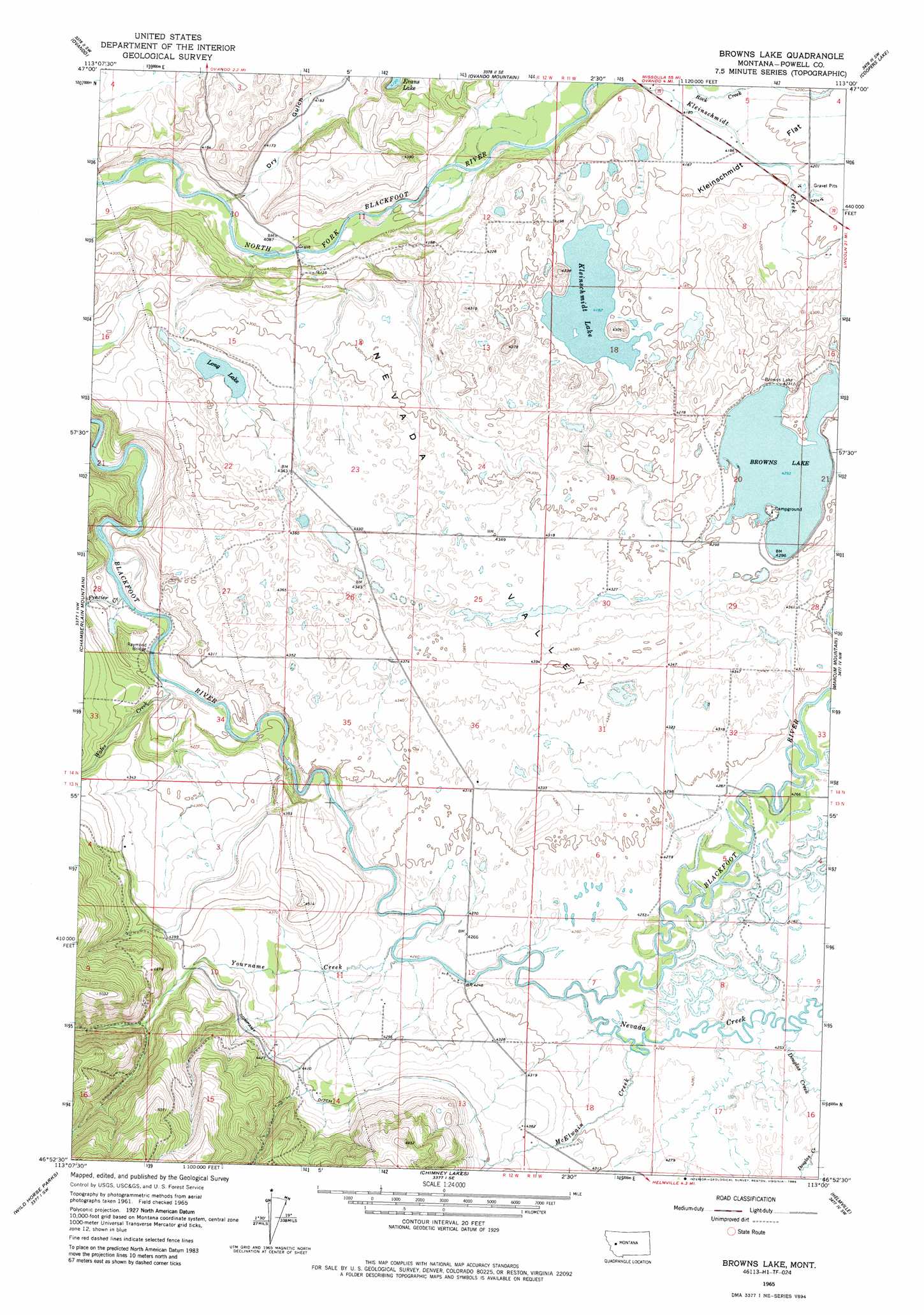
USGS Topo Quad 46113h1 - 1:24,000 scale
| Topo Map Name: | Browns Lake |
| USGS Topo Quad ID: | 46113h1 |
| Print Size: | ca. 21 1/4" wide x 27" high |
| Southeast Coordinates: | 46.875° N latitude / 113° W longitude |
| Map Center Coordinates: | 46.9375° N latitude / 113.0625° W longitude |
| U.S. State: | MT |
| Filename: | o46113h1.jpg |
| Download Map JPG Image: | Browns Lake topo map 1:24,000 scale |
| Map Type: | Topographic |
| Topo Series: | 7.5´ |
| Map Scale: | 1:24,000 |
| Source of Map Images: | United States Geological Survey (USGS) |
| Alternate Map Versions: |
Browns Lake MT 1965, updated 1967 Download PDF Buy paper map Browns Lake MT 1965, updated 1981 Download PDF Buy paper map Browns Lake MT 1965, updated 1986 Download PDF Buy paper map Browns Lake MT 2011 Download PDF Buy paper map Browns Lake MT 2014 Download PDF Buy paper map |
1:24,000 Topo Quads surrounding Browns Lake
Morrell Mountain |
Dunham Point |
Spread Mountain |
Lake Mountain |
Olson Peak |
Woodworth |
Ovando |
Ovando Mountain |
Coopers Lake |
Arrastra Mountain |
Bata Mountain |
Chamberlain Mountain |
Browns Lake |
Marcum Mountain |
Moose Creek |
Elevation Mountain |
Wild Horse Parks |
Chimney Lakes |
Helmville |
Nevada Lake |
Bearmouth |
Drummond |
Limestone Ridge |
Bailey Mountain |
Windy Rock |
> Back to 46113e1 at 1:100,000 scale
> Back to 46112a1 at 1:250,000 scale
> Back to U.S. Topo Maps home
Browns Lake topo map: Gazetteer
Browns Lake: Bridges
Raymond Bridge elevation 1267m 4156′Browns Lake: Canals
Company Ditch elevation 1348m 4422′Browns Lake: Lakes
Browns Lake elevation 1310m 4297′Kleinschmidt Lake elevation 1276m 4186′
Browns Lake: Mines
First Chance Creek Placer Mine elevation 1312m 4304′Browns Lake: Post Offices
Lake City Post Office (historical) elevation 1315m 4314′Browns Lake: Streams
Douglas Creek elevation 1299m 4261′Frazier Creek elevation 1263m 4143′
Kleinschmidt Creek elevation 1269m 4163′
McElwain Creek elevation 1299m 4261′
Nevada Creek elevation 1296m 4251′
Rock Creek elevation 1269m 4163′
Wales Creek elevation 1269m 4163′
Ward Creek elevation 1310m 4297′
Yourname Creek elevation 1292m 4238′
Browns Lake: Valleys
Dry Gulch elevation 1237m 4058′Nevada Valley elevation 1280m 4199′
Browns Lake: Wells
13N12W12CAAA02 Well elevation 1301m 4268′13N12W12CAAB01 Well elevation 1301m 4268′
13N12W12DCDD01 Well elevation 1322m 4337′
14N11W08ADAC01 Well elevation 1281m 4202′
14N12W22DBAD01 Well elevation 1327m 4353′
14N12W36DCCC01 Well elevation 1318m 4324′
Browns Lake digital topo map on disk
Buy this Browns Lake topo map showing relief, roads, GPS coordinates and other geographical features, as a high-resolution digital map file on DVD: