Dunham Point Topo Map Montana
To zoom in, hover over the map of Dunham Point
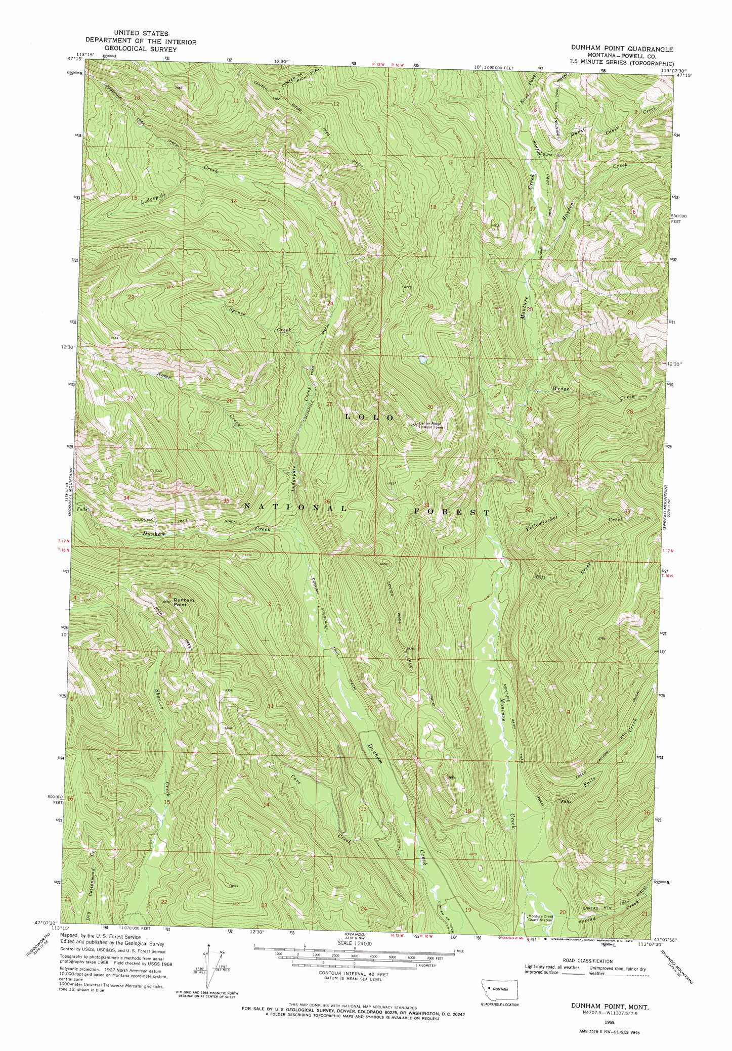
USGS Topo Quad 47113b2 - 1:24,000 scale
| Topo Map Name: | Dunham Point |
| USGS Topo Quad ID: | 47113b2 |
| Print Size: | ca. 21 1/4" wide x 27" high |
| Southeast Coordinates: | 47.125° N latitude / 113.125° W longitude |
| Map Center Coordinates: | 47.1875° N latitude / 113.1875° W longitude |
| U.S. State: | MT |
| Filename: | o47113b2.jpg |
| Download Map JPG Image: | Dunham Point topo map 1:24,000 scale |
| Map Type: | Topographic |
| Topo Series: | 7.5´ |
| Map Scale: | 1:24,000 |
| Source of Map Images: | United States Geological Survey (USGS) |
| Alternate Map Versions: |
Dunham Point MT 1968, updated 1970 Download PDF Buy paper map Dunham Point MT 1999, updated 2003 Download PDF Buy paper map Dunham Point MT 2011 Download PDF Buy paper map Dunham Point MT 2014 Download PDF Buy paper map |
| FStopo: | US Forest Service topo Dunham Point is available: Download FStopo PDF Download FStopo TIF |
1:24,000 Topo Quads surrounding Dunham Point
Shaw Creek |
Una Mountain |
Pilot Peak |
Trap Mountain |
Benchmark |
Morrell Lake |
Crimson Peak |
Hahn Creek Pass |
Danaher Mountain |
Flint Mountain |
Seeley Lake East |
Morrell Mountain |
Dunham Point |
Spread Mountain |
Lake Mountain |
Salmon Lake |
Woodworth |
Ovando |
Ovando Mountain |
Coopers Lake |
Greenough |
Bata Mountain |
Chamberlain Mountain |
Browns Lake |
Marcum Mountain |
> Back to 47113a1 at 1:100,000 scale
> Back to 47112a1 at 1:250,000 scale
> Back to U.S. Topo Maps home
Dunham Point topo map: Gazetteer
Dunham Point: Streams
Bill Creek elevation 1341m 4399′Burnt Cabin Creek elevation 1553m 5095′
Cave Creek elevation 1291m 4235′
East Fork Monture Creek elevation 1580m 5183′
East Fork Spread Creek elevation 1473m 4832′
Falls Creek elevation 1288m 4225′
Hayden Creek elevation 1530m 5019′
Lodgepole Creek elevation 1373m 4504′
Monture Creek elevation 1323m 4340′
Nome Creek elevation 1423m 4668′
Spread Creek elevation 1271m 4169′
Spruce Creek elevation 1555m 5101′
Wedge Creek elevation 1485m 4872′
Yellowjacket Creek elevation 1349m 4425′
Dunham Point: Summits
Dunham Point elevation 2042m 6699′Dunham Point: Trails
Center Ridge Trail elevation 1901m 6236′Dunham Lodgepole Trail elevation 1338m 4389′
Lodgepole Trail elevation 1627m 5337′
Monture Haun Trail elevation 1449m 4753′
Dunham Point: Wells
16N12W20CBBA01 Well elevation 1277m 4189′Dunham Point digital topo map on disk
Buy this Dunham Point topo map showing relief, roads, GPS coordinates and other geographical features, as a high-resolution digital map file on DVD: