Coopers Lake Topo Map Montana
To zoom in, hover over the map of Coopers Lake
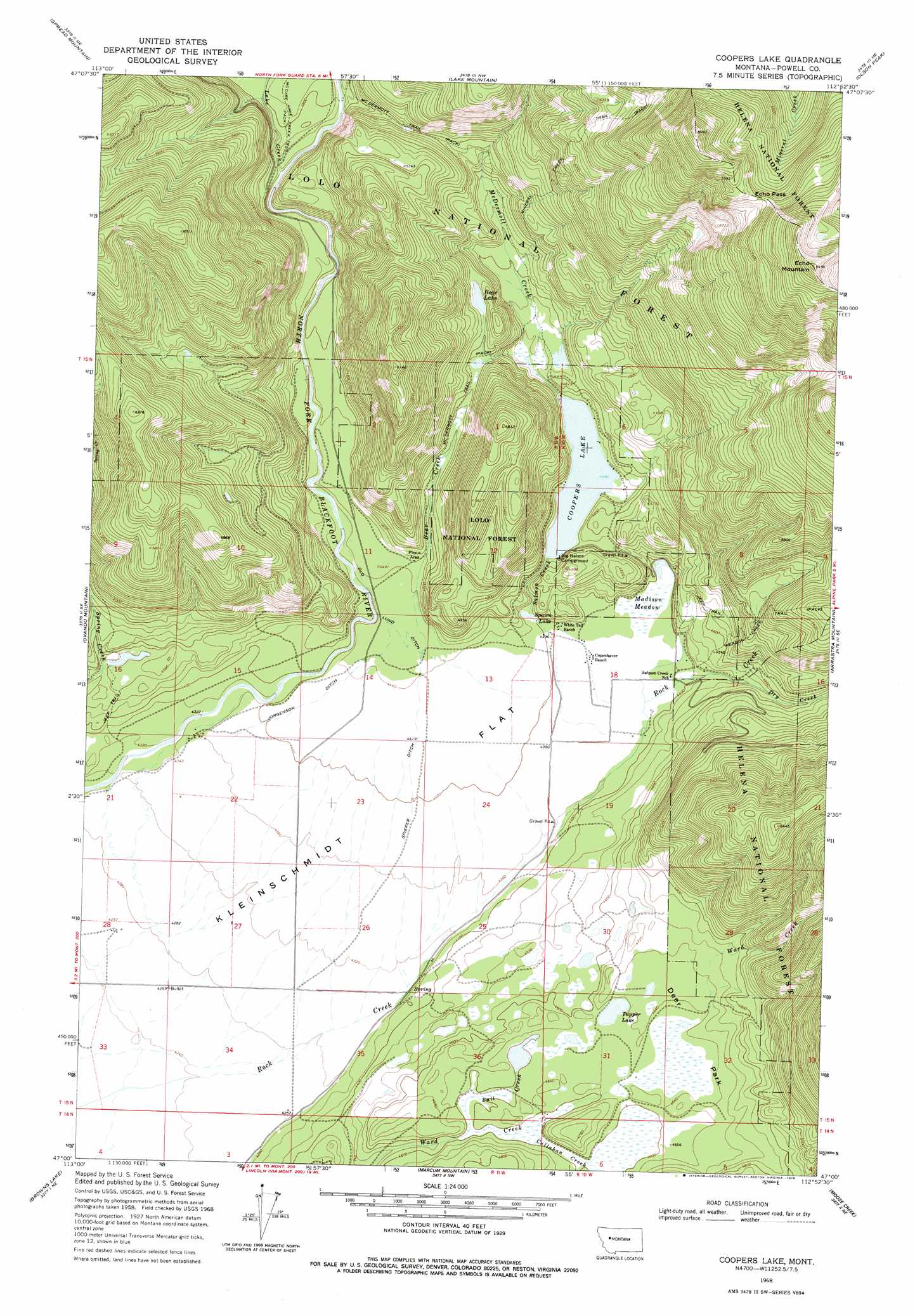
USGS Topo Quad 47112a8 - 1:24,000 scale
| Topo Map Name: | Coopers Lake |
| USGS Topo Quad ID: | 47112a8 |
| Print Size: | ca. 21 1/4" wide x 27" high |
| Southeast Coordinates: | 47° N latitude / 112.875° W longitude |
| Map Center Coordinates: | 47.0625° N latitude / 112.9375° W longitude |
| U.S. State: | MT |
| Filename: | o47112a8.jpg |
| Download Map JPG Image: | Coopers Lake topo map 1:24,000 scale |
| Map Type: | Topographic |
| Topo Series: | 7.5´ |
| Map Scale: | 1:24,000 |
| Source of Map Images: | United States Geological Survey (USGS) |
| Alternate Map Versions: |
Coopers Lake MT 1968, updated 1971 Download PDF Buy paper map Coopers Lake MT 1968, updated 1978 Download PDF Buy paper map Coopers Lake MT 1999, updated 2003 Download PDF Buy paper map Coopers Lake MT 2011 Download PDF Buy paper map Coopers Lake MT 2014 Download PDF Buy paper map |
| FStopo: | US Forest Service topo Coopers Lake is available: Download FStopo PDF Download FStopo TIF |
1:24,000 Topo Quads surrounding Coopers Lake
Hahn Creek Pass |
Danaher Mountain |
Flint Mountain |
Scapegoat Mountain |
Jakie Creek |
Dunham Point |
Spread Mountain |
Lake Mountain |
Olson Peak |
Heart Lake |
Ovando |
Ovando Mountain |
Coopers Lake |
Arrastra Mountain |
Stonewall Mountain |
Chamberlain Mountain |
Browns Lake |
Marcum Mountain |
Moose Creek |
Lincoln |
Wild Horse Parks |
Chimney Lakes |
Helmville |
Nevada Lake |
Finn |
> Back to 47112a1 at 1:100,000 scale
> Back to 47112a1 at 1:250,000 scale
> Back to U.S. Topo Maps home
Coopers Lake topo map: Gazetteer
Coopers Lake: Canals
Jorgenson Ditch elevation 1349m 4425′Old Lund Ditch elevation 1361m 4465′
Spieker Ditch elevation 1338m 4389′
Coopers Lake: Flats
Deer Park elevation 1415m 4642′Kleinschmidt Flat elevation 1311m 4301′
Coopers Lake: Gaps
Echo Pass elevation 2258m 7408′Coopers Lake: Guts
Bear Creek elevation 1366m 4481′Coopers Lake: Lakes
Bear Lake elevation 1482m 4862′Coopers Lake elevation 1370m 4494′
Spawn Lake elevation 1348m 4422′
Tupper Lake elevation 1413m 4635′
Coopers Lake: Streams
Bull Creek elevation 1403m 4603′Callahan Creek elevation 1399m 4589′
Dry Creek elevation 1362m 4468′
Lake Creek elevation 1423m 4668′
McDermott Creek elevation 1376m 4514′
Salmon Creek elevation 1336m 4383′
Coopers Lake: Summits
Echo Mountain elevation 2554m 8379′Coopers Lake: Swamps
Madison Meadow elevation 1337m 4386′Coopers Lake: Trails
Mineral Creek Trail elevation 2011m 6597′Coopers Lake: Wells
15N11W02BCBA01 Well elevation 1393m 4570′15N11W02CBBD01 Well elevation 1381m 4530′
15N11W28DBBC01 Well elevation 1301m 4268′
Coopers Lake digital topo map on disk
Buy this Coopers Lake topo map showing relief, roads, GPS coordinates and other geographical features, as a high-resolution digital map file on DVD: