Makinen Topo Map Minnesota
To zoom in, hover over the map of Makinen
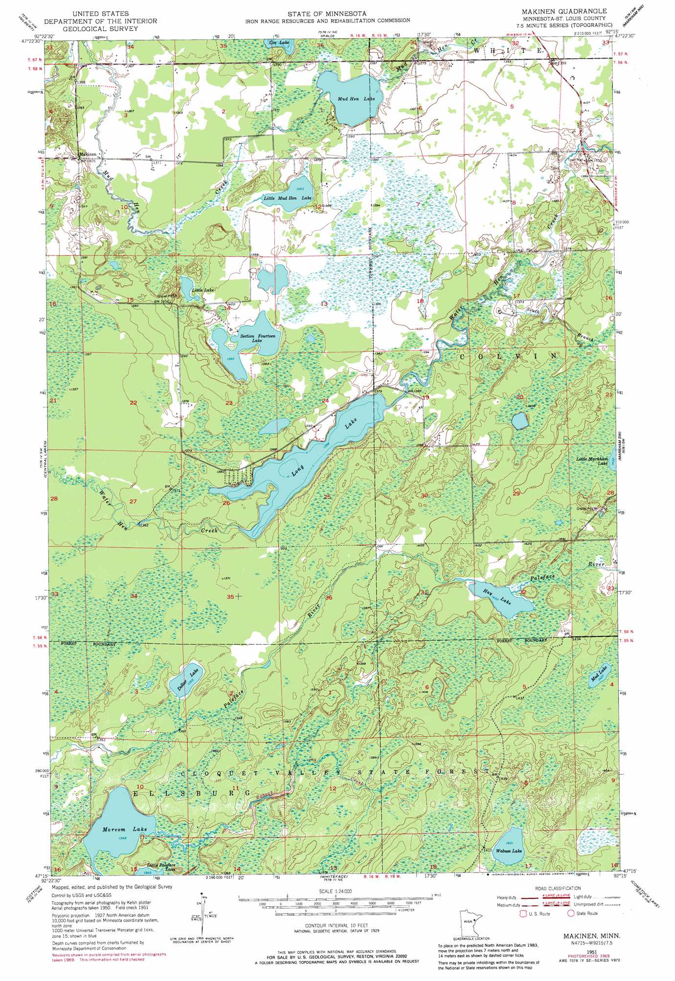
USGS Topo Quad 47092c3 - 1:24,000 scale
| Topo Map Name: | Makinen |
| USGS Topo Quad ID: | 47092c3 |
| Print Size: | ca. 21 1/4" wide x 27" high |
| Southeast Coordinates: | 47.25° N latitude / 92.25° W longitude |
| Map Center Coordinates: | 47.3125° N latitude / 92.3125° W longitude |
| U.S. State: | MN |
| Filename: | o47092c3.jpg |
| Download Map JPG Image: | Makinen topo map 1:24,000 scale |
| Map Type: | Topographic |
| Topo Series: | 7.5´ |
| Map Scale: | 1:24,000 |
| Source of Map Images: | United States Geological Survey (USGS) |
| Alternate Map Versions: |
Makinen MN 1951, updated 1953 Download PDF Buy paper map Makinen MN 1951, updated 1965 Download PDF Buy paper map Makinen MN 1951, updated 1971 Download PDF Buy paper map Makinen MN 1951, updated 1983 Download PDF Buy paper map Makinen MN 2010 Download PDF Buy paper map Makinen MN 2013 Download PDF Buy paper map Makinen MN 2016 Download PDF Buy paper map |
1:24,000 Topo Quads surrounding Makinen
Virginia |
Mckinley |
Biwabik |
Aurora |
Allen |
Eveleth |
Gilbert |
Palo |
Turpela Lake |
Bird Lake |
Zim |
Central Lakes |
Makinen |
Whiteface Reservoir |
Harris Lake |
Kelsey |
Cotton |
Whiteface |
Comstock Lake |
Boulder Lake Reservoir Ne |
Payne |
Canyon |
Shaw |
Boulder Lake Reservoir |
Thompson Lake |
> Back to 47092a1 at 1:100,000 scale
> Back to 47092a1 at 1:250,000 scale
> Back to U.S. Topo Maps home
Makinen topo map: Gazetteer
Makinen: Lakes
Dollar Lake elevation 416m 1364′Hay Lake elevation 428m 1404′
Little Lake elevation 420m 1377′
Little Mud Hen Lake elevation 417m 1368′
Long Lake elevation 414m 1358′
Morcom Lake elevation 409m 1341′
Mud Hen Lake elevation 418m 1371′
Mud Lake elevation 435m 1427′
Section Fourteen Lake elevation 421m 1381′
Wabuse Lake elevation 427m 1400′
Makinen: Populated Places
Makinen elevation 427m 1400′Makinen: Post Offices
Makinen Post Office elevation 427m 1400′Makinen: Streams
Bobcat Creek elevation 410m 1345′South Branch Water Hen Creek elevation 415m 1361′
Makinen digital topo map on disk
Buy this Makinen topo map showing relief, roads, GPS coordinates and other geographical features, as a high-resolution digital map file on DVD: