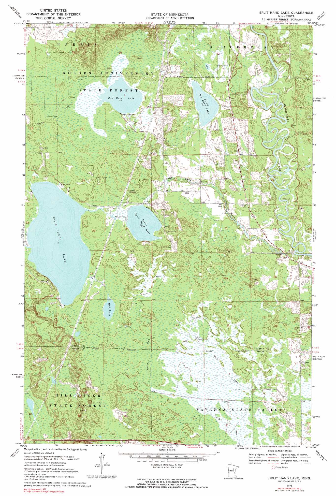
Split Hand Lake Topo Map Minnesota
To zoom in, hover over the map of Split Hand Lake
USGS Topo Quad 47093a4 - 1:24,000 scale
| Topo Map Name: | Split Hand Lake |
| USGS Topo Quad ID: | 47093a4 |
| Print Size: | ca. 21 1/4" wide x 27" high |
| Southeast Coordinates: | 47° N latitude / 93.375° W longitude |
| Map Center Coordinates: | 47.0625° N latitude / 93.4375° W longitude |
| U.S. State: | MN |
| Filename: | o47093a4.jpg |
| Download Map JPG Image: | Split Hand Lake topo map 1:24,000 scale |
| Map Type: | Topographic |
| Topo Series: | 7.5´ |
| Map Scale: | 1:24,000 |
| Source of Map Images: | United States Geological Survey (USGS) |
| Alternate Map Versions: |
Split Hand Lake MN 1970, updated 1972 Download PDF Buy paper map Split Hand Lake MN 1970, updated 1991 Download PDF Buy paper map Split Hand Lake MN 2010 Download PDF Buy paper map Split Hand Lake MN 2013 Download PDF Buy paper map Split Hand Lake MN 2016 Download PDF Buy paper map |
1:24,000 Topo Quads surrounding Split Hand Lake
Cohasset West |
Cohasset East |
Bovey |
Calumet |
Pengilly |
Siseebakwet Lake |
Grand Rapids |
La Prairie |
Warba |
Goodland |
Big Thunder Peak |
Mountain Ash Lake |
Split Hand Lake |
Jacobson |
Swan River |
Swatara |
Hill City |
Rabey |
Ball Bluff |
Vanduse Lake |
White Elk Lake |
Bain |
Sanders Lake |
Libby |
Balsam |
> Back to 47093a1 at 1:100,000 scale
> Back to 47092a1 at 1:250,000 scale
> Back to U.S. Topo Maps home
Split Hand Lake topo map: Gazetteer
Split Hand Lake: Airports
Porter Airport elevation 387m 1269′Split Hand Lake: Dams
Little Splithand Lake Dam elevation 384m 1259′Splithand Lake Dam elevation 386m 1266′
Split Hand Lake: Forests
Golden Anniversary State Forest elevation 390m 1279′Split Hand Lake: Lakes
Cow Horn Lake elevation 389m 1276′Little Cow Horn Lake elevation 385m 1263′
Little Split Hand Lake elevation 384m 1259′
Mud Lake elevation 386m 1266′
Split Hand Lake: Post Offices
Splithand Post Office (historical) elevation 383m 1256′Split Hand Lake: Reservoirs
Little Splithand Lake elevation 384m 1259′Split Hand Lake elevation 385m 1263′
Splithand Lake elevation 386m 1266′
Split Hand Lake: Streams
Split Hand Creek elevation 379m 1243′Split Hand Lake digital topo map on disk
Buy this Split Hand Lake topo map showing relief, roads, GPS coordinates and other geographical features, as a high-resolution digital map file on DVD: