Bovey Topo Map Minnesota
To zoom in, hover over the map of Bovey
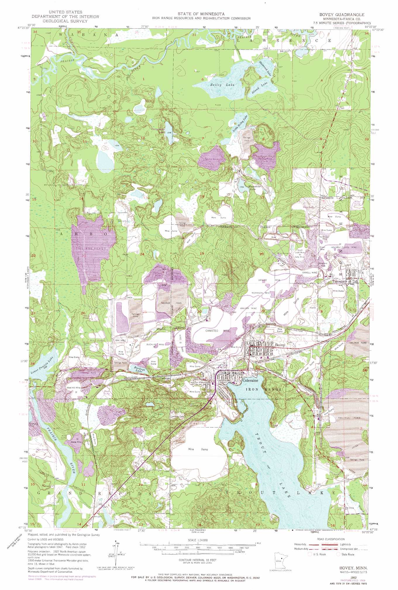
USGS Topo Quad 47093c4 - 1:24,000 scale
| Topo Map Name: | Bovey |
| USGS Topo Quad ID: | 47093c4 |
| Print Size: | ca. 21 1/4" wide x 27" high |
| Southeast Coordinates: | 47.25° N latitude / 93.375° W longitude |
| Map Center Coordinates: | 47.3125° N latitude / 93.4375° W longitude |
| U.S. State: | MN |
| Filename: | o47093c4.jpg |
| Download Map JPG Image: | Bovey topo map 1:24,000 scale |
| Map Type: | Topographic |
| Topo Series: | 7.5´ |
| Map Scale: | 1:24,000 |
| Source of Map Images: | United States Geological Survey (USGS) |
| Alternate Map Versions: |
Bovey MN 1952, updated 1954 Download PDF Buy paper map Bovey MN 1952, updated 1968 Download PDF Buy paper map Bovey MN 1952, updated 1971 Download PDF Buy paper map Bovey MN 2010 Download PDF Buy paper map Bovey MN 2013 Download PDF Buy paper map Bovey MN 2016 Download PDF Buy paper map |
1:24,000 Topo Quads surrounding Bovey
Marcell |
Clubhouse Lake |
Balsam Lake |
Hartley Lake |
O'Leary Lake |
Little Bowstring Lake |
Wabana Lake |
Lawrence Lake West |
Lawrence Lake East |
Nashwauk |
Cohasset West |
Cohasset East |
Bovey |
Calumet |
Pengilly |
Siseebakwet Lake |
Grand Rapids |
La Prairie |
Warba |
Goodland |
Big Thunder Peak |
Mountain Ash Lake |
Split Hand Lake |
Jacobson |
Swan River |
> Back to 47093a1 at 1:100,000 scale
> Back to 47092a1 at 1:250,000 scale
> Back to U.S. Topo Maps home
Bovey topo map: Gazetteer
Bovey: Dams
Arcturus Tailings Dike elevation 424m 1391′Arcturus Water Supply Dike elevation 423m 1387′
Buckeye Two Tailings Dike elevation 427m 1400′
Hunner Tailings Dike elevation 405m 1328′
Prairie River Dam elevation 391m 1282′
Trout Lake Tailings Dike elevation 403m 1322′
Bovey: Lakes
Buckeye Lake elevation 403m 1322′Dirty Mike Lake elevation 402m 1318′
Island Lake elevation 398m 1305′
Little Reiley Lake elevation 399m 1309′
Moonshine Lake elevation 425m 1394′
Reiley Lake elevation 398m 1305′
Shamrock Lake elevation 398m 1305′
Trout Lake elevation 393m 1289′
Bovey: Mines
Bingham Mine elevation 427m 1400′Brown Mine elevation 430m 1410′
Buckeye Mine elevation 421m 1381′
Canisteo Mine elevation 419m 1374′
Danube Mine elevation 428m 1404′
Holman Cliffs Mine elevation 415m 1361′
Jessie Mine elevation 396m 1299′
Judd Mine elevation 430m 1410′
King Mine elevation 424m 1391′
Morrison Mine elevation 424m 1391′
North Star Mine elevation 428m 1404′
Orwell Mine elevation 428m 1404′
Sally Mine elevation 433m 1420′
South Judd Mine elevation 435m 1427′
Walker Mine elevation 416m 1364′
West Hill Mine elevation 411m 1348′
Bovey: Populated Places
Bovey elevation 401m 1315′Canisteo elevation 410m 1345′
Coleraine elevation 403m 1322′
Taconite elevation 426m 1397′
Bovey: Post Offices
Bovey Post Office elevation 409m 1341′Coleraine Post Office elevation 403m 1322′
Taconite Post Office elevation 425m 1394′
Bovey: Reservoirs
Arcturus Tailings Basin elevation 424m 1391′Arcturus Water Supply Basin elevation 423m 1387′
Buckeye Two Tailings Basin elevation 427m 1400′
Hunner Tailings Basin elevation 405m 1328′
Lower Prairie Lake elevation 394m 1292′
Prairie Lake elevation 391m 1282′
Trout Lake Tailings Basin elevation 403m 1322′
Bovey: Streams
Clearwater Creek elevation 396m 1299′Bovey digital topo map on disk
Buy this Bovey topo map showing relief, roads, GPS coordinates and other geographical features, as a high-resolution digital map file on DVD: