Calumet Topo Map Minnesota
To zoom in, hover over the map of Calumet
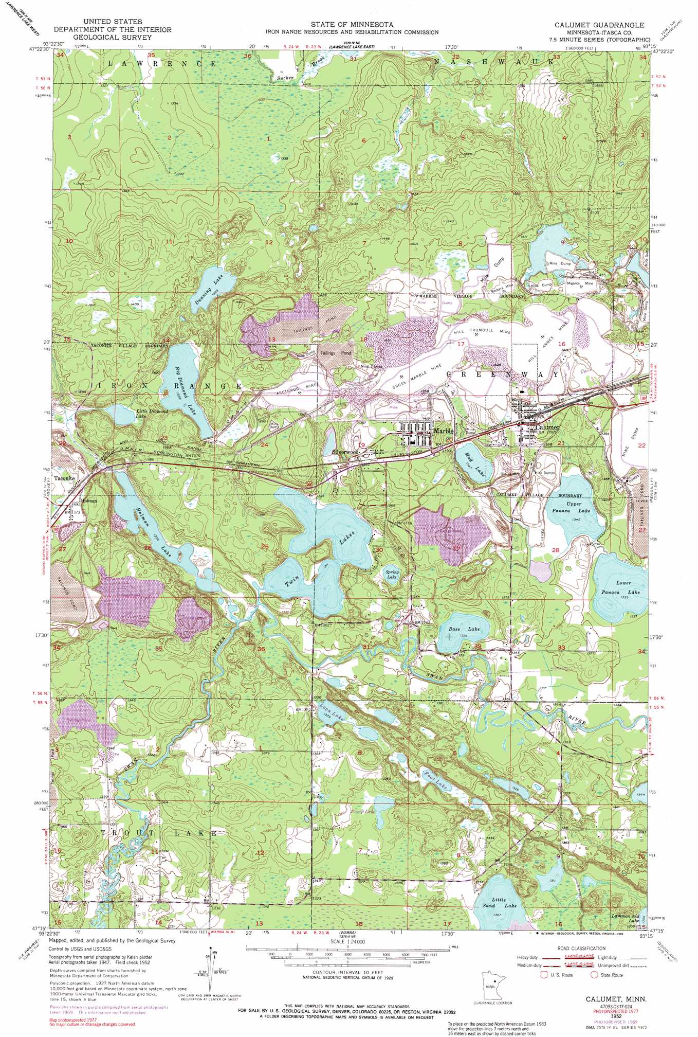
USGS Topo Quad 47093c3 - 1:24,000 scale
| Topo Map Name: | Calumet |
| USGS Topo Quad ID: | 47093c3 |
| Print Size: | ca. 21 1/4" wide x 27" high |
| Southeast Coordinates: | 47.25° N latitude / 93.25° W longitude |
| Map Center Coordinates: | 47.3125° N latitude / 93.3125° W longitude |
| U.S. State: | MN |
| Filename: | o47093c3.jpg |
| Download Map JPG Image: | Calumet topo map 1:24,000 scale |
| Map Type: | Topographic |
| Topo Series: | 7.5´ |
| Map Scale: | 1:24,000 |
| Source of Map Images: | United States Geological Survey (USGS) |
| Alternate Map Versions: |
Calumet MN 1952, updated 1954 Download PDF Buy paper map Calumet MN 1952, updated 1971 Download PDF Buy paper map Calumet MN 2010 Download PDF Buy paper map Calumet MN 2013 Download PDF Buy paper map Calumet MN 2016 Download PDF Buy paper map |
1:24,000 Topo Quads surrounding Calumet
Clubhouse Lake |
Balsam Lake |
Hartley Lake |
O'Leary Lake |
Stingy Lake |
Wabana Lake |
Lawrence Lake West |
Lawrence Lake East |
Nashwauk |
Keewatin |
Cohasset East |
Bovey |
Calumet |
Pengilly |
Silica |
Grand Rapids |
La Prairie |
Warba |
Goodland |
Floodwood Lake |
Mountain Ash Lake |
Split Hand Lake |
Jacobson |
Swan River |
Wawina |
> Back to 47093a1 at 1:100,000 scale
> Back to 47092a1 at 1:250,000 scale
> Back to U.S. Topo Maps home
Calumet topo map: Gazetteer
Calumet: Dams
Hill Annex Dike One elevation 420m 1377′Hill Annex Dike Three elevation 423m 1387′
Calumet: Lakes
Bass Lake elevation 404m 1325′Big Diamond Lake elevation 408m 1338′
Dunning Lake elevation 416m 1364′
Foot Lake elevation 404m 1325′
Holman Lake elevation 399m 1309′
Little Diamond Lake elevation 405m 1328′
Little Sand Lake elevation 399m 1309′
Loon Lake elevation 405m 1328′
Lower Panaca Lake elevation 407m 1335′
Mud Lake elevation 411m 1348′
Spring Lake elevation 400m 1312′
Twin Lakes elevation 400m 1312′
Upper Panaca Lake elevation 409m 1341′
Calumet: Mines
Arcturus Mine elevation 430m 1410′Barbara Mine elevation 447m 1466′
Gross -Marble Mine elevation 430m 1410′
Hill -Annex Mine elevation 437m 1433′
Hill Trumbull Mine elevation 443m 1453′
Majorca Mine elevation 442m 1450′
Calumet: Parks
Geology of the Hill Annex Mine Geological Marker elevation 455m 1492′Calumet: Populated Places
Calumet elevation 421m 1381′Holman elevation 421m 1381′
Marble elevation 432m 1417′
Silverwood elevation 426m 1397′
Twin Lake Trails Mobile Home Park elevation 415m 1361′
Calumet: Post Offices
Calumet Post Office elevation 418m 1371′Marble Post Office elevation 432m 1417′
Calumet: Reservoirs
Hill Annex Pond One elevation 420m 1377′Hill Annex Pond Three elevation 423m 1387′
Calumet digital topo map on disk
Buy this Calumet topo map showing relief, roads, GPS coordinates and other geographical features, as a high-resolution digital map file on DVD: