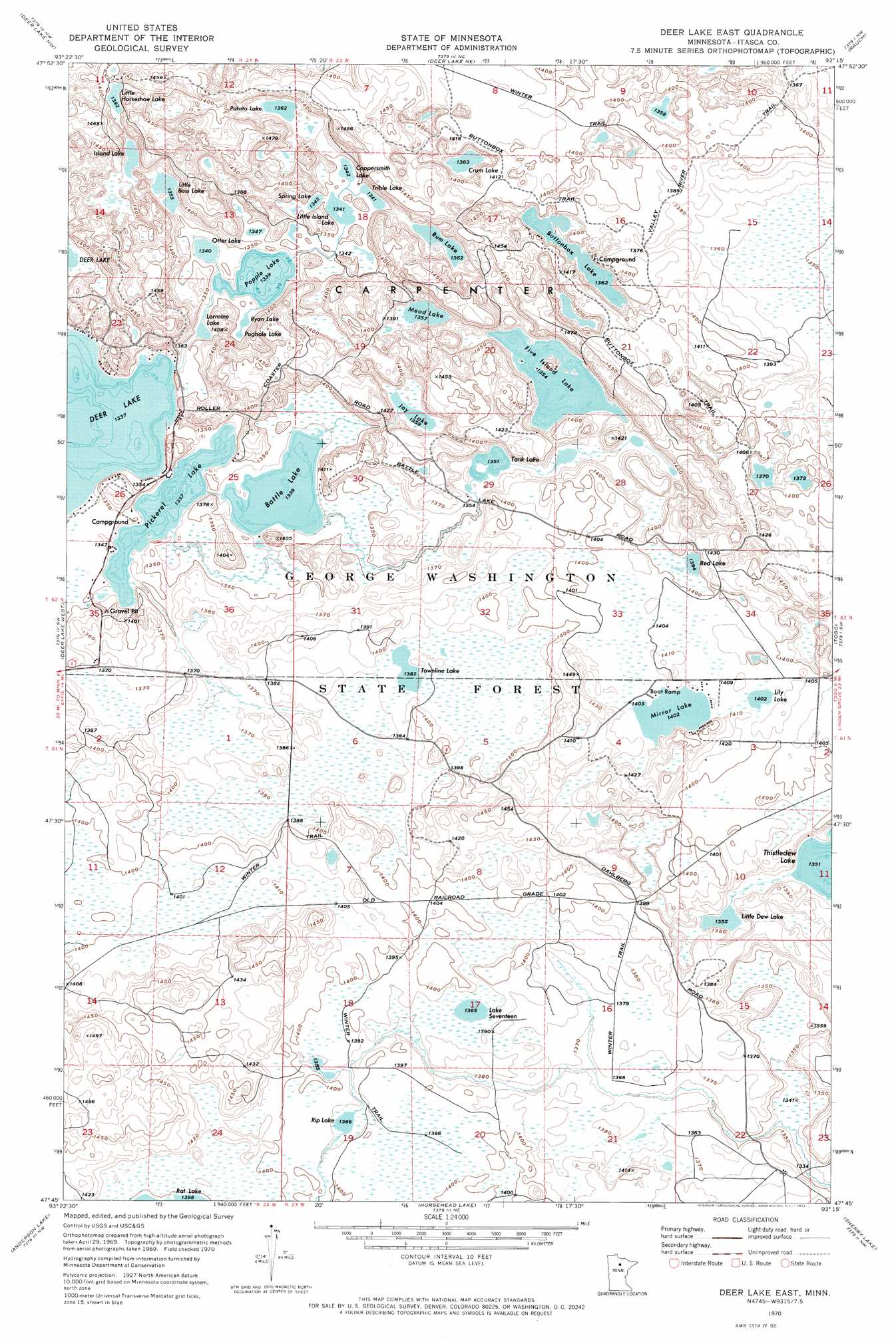
Deer Lake East Topo Map Minnesota
To zoom in, hover over the map of Deer Lake East
USGS Topo Quad 47093g3 - 1:24,000 scale
| Topo Map Name: | Deer Lake East |
| USGS Topo Quad ID: | 47093g3 |
| Print Size: | ca. 21 1/4" wide x 27" high |
| Southeast Coordinates: | 47.75° N latitude / 93.25° W longitude |
| Map Center Coordinates: | 47.8125° N latitude / 93.3125° W longitude |
| U.S. State: | MN |
| Filename: | o47093g3.jpg |
| Download Map JPG Image: | Deer Lake East topo map 1:24,000 scale |
| Map Type: | Topographic |
| Topo Series: | 7.5´ |
| Map Scale: | 1:24,000 |
| Source of Map Images: | United States Geological Survey (USGS) |
| Alternate Map Versions: |
Deer Lake East MN 1970, updated 1973 Download PDF Buy paper map Deer Lake East MN 2010 Download PDF Buy paper map Deer Lake East MN 2013 Download PDF Buy paper map Deer Lake East MN 2016 Download PDF Buy paper map |
1:24,000 Topo Quads surrounding Deer Lake East
Johnson Landing Se |
Nett Lake River Sw |
Nett Lake River Se |
Nett Lake Sw |
Nett Lake |
Craigville |
Deer Lake Nw |
Deer Lake Ne |
Rauch |
Silverdale |
Effie Se |
Deer Lake West |
Deer Lake East |
Togo |
Bear River |
Coon Lake |
Anderson Lake |
Horsehead Lake |
Sherry Lake |
Side Lake |
Clubhouse Lake |
Balsam Lake |
Hartley Lake |
O'Leary Lake |
Stingy Lake |
> Back to 47093e1 at 1:100,000 scale
> Back to 47092a1 at 1:250,000 scale
> Back to U.S. Topo Maps home
Deer Lake East topo map: Gazetteer
Deer Lake East: Lakes
Battle Lake elevation 408m 1338′Buttonbox Lake elevation 415m 1361′
Coppersmith Lake elevation 410m 1345′
Crum Lake elevation 415m 1361′
Five Island Lake elevation 412m 1351′
Island Lake elevation 415m 1361′
Joy Lake elevation 414m 1358′
Lake Seventeen elevation 422m 1384′
Lily Lake elevation 429m 1407′
Little Bass Lake elevation 412m 1351′
Little Dew Lake elevation 413m 1354′
Little Horseshoe Lake elevation 425m 1394′
Little Island Lake elevation 410m 1345′
Lorraine Lake elevation 406m 1332′
Mead Lake elevation 412m 1351′
Mirror Lake elevation 428m 1404′
Otter Lake elevation 408m 1338′
Pickerel Lake elevation 408m 1338′
Popple Lake elevation 408m 1338′
Potato Lake elevation 415m 1361′
Pughole Lake elevation 409m 1341′
Red Lake elevation 425m 1394′
Rip Lake elevation 422m 1384′
Rum Lake elevation 415m 1361′
Ryan Lake elevation 409m 1341′
Spring Lake elevation 409m 1341′
Tank Lake elevation 412m 1351′
Townline Lake elevation 422m 1384′
Trible Lake elevation 409m 1341′
Deer Lake East: Trails
Buttonbox Trail elevation 431m 1414′Valley River Trail elevation 427m 1400′
Deer Lake East digital topo map on disk
Buy this Deer Lake East topo map showing relief, roads, GPS coordinates and other geographical features, as a high-resolution digital map file on DVD: