Steamboat Creek Topo Map Idaho
To zoom in, hover over the map of Steamboat Creek
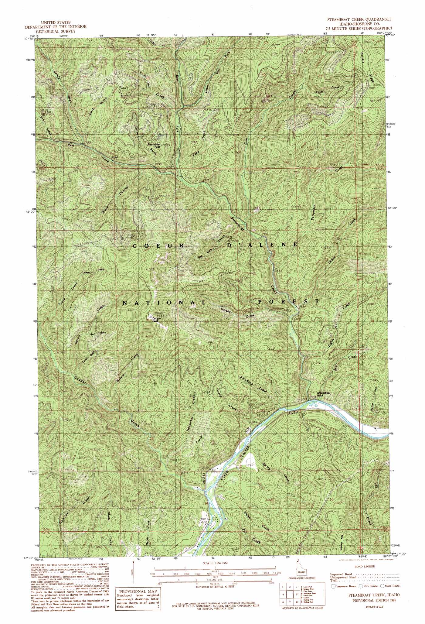
USGS Topo Quad 47116f2 - 1:24,000 scale
| Topo Map Name: | Steamboat Creek |
| USGS Topo Quad ID: | 47116f2 |
| Print Size: | ca. 21 1/4" wide x 27" high |
| Southeast Coordinates: | 47.625° N latitude / 116.125° W longitude |
| Map Center Coordinates: | 47.6875° N latitude / 116.1875° W longitude |
| U.S. State: | ID |
| Filename: | o47116f2.jpg |
| Download Map JPG Image: | Steamboat Creek topo map 1:24,000 scale |
| Map Type: | Topographic |
| Topo Series: | 7.5´ |
| Map Scale: | 1:24,000 |
| Source of Map Images: | United States Geological Survey (USGS) |
| Alternate Map Versions: |
Steamboat Creek ID 1985, updated 1985 Download PDF Buy paper map Steamboat Creek ID 1996, updated 1999 Download PDF Buy paper map Steamboat Creek ID 2011 Download PDF Buy paper map Steamboat Creek ID 2014 Download PDF Buy paper map |
| FStopo: | US Forest Service topo Steamboat Creek is available: Download FStopo PDF Download FStopo TIF |
1:24,000 Topo Quads surrounding Steamboat Creek
Lakeview |
Faset Peak |
Cathedral Peak |
Jordan Creek |
Gem Peak |
Cataract Peak |
Lamb Peak |
Spyglass Peak |
Pond Peak |
Taylor Peak |
Skitwish Peak |
Bumblebee Peak |
Steamboat Creek |
Grizzly Mountain |
Prichard |
Rose Lake |
Cataldo |
Kellogg West |
Kellogg East |
Osburn |
Rochat Peak |
Twin Crags |
Masonia |
Polaris Peak |
Wallace |
> Back to 47116e1 at 1:100,000 scale
> Back to 47116a1 at 1:250,000 scale
> Back to U.S. Topo Maps home
Steamboat Creek topo map: Gazetteer
Steamboat Creek: Gaps
Black Canyon Saddle elevation 1313m 4307′Steamboat Creek: Pillars
Steamboat Rock elevation 750m 2460′Steamboat Creek: Populated Places
Steamboat (historical) elevation 811m 2660′Steamboat Creek: Streams
Barrymore Creek elevation 732m 2401′Betty Creek elevation 883m 2896′
Big Bob Creek elevation 745m 2444′
Boston Brook elevation 800m 2624′
Cabin Creek elevation 875m 2870′
Can Creek elevation 739m 2424′
Comfy Creek elevation 850m 2788′
Dennis Creek elevation 775m 2542′
East Fork Steamboat Creek elevation 776m 2545′
Eighty Day Creek elevation 714m 2342′
Fall Creek elevation 677m 2221′
Felder Creek elevation 1043m 3421′
Guard Creek elevation 690m 2263′
Indian Creek elevation 716m 2349′
June Creek elevation 776m 2545′
Little East Fork Steamboat Creek elevation 849m 2785′
Long Tom Creek elevation 821m 2693′
McRae Creek elevation 683m 2240′
Nelson Creek elevation 730m 2395′
November Creek elevation 694m 2276′
Omaha Creek elevation 702m 2303′
Pablo Creek elevation 688m 2257′
Scott Creek elevation 683m 2240′
Smith Creek elevation 679m 2227′
Spring Creek elevation 679m 2227′
Steamboat Creek elevation 682m 2237′
Timber Creek elevation 839m 2752′
West Fork Steamboat Creek elevation 776m 2545′
Steamboat Creek: Summits
Cougar Peak Loookout elevation 1612m 5288′Steamboat Peak elevation 1013m 3323′
Steamboat Creek: Valleys
Black Canyon elevation 843m 2765′Carrol Gulch elevation 877m 2877′
Clark Gulch elevation 850m 2788′
Cougar Gulch elevation 679m 2227′
Drew Gulch elevation 986m 3234′
Simmons Draw elevation 761m 2496′
Weyer Gulch elevation 1107m 3631′
Steamboat Creek digital topo map on disk
Buy this Steamboat Creek topo map showing relief, roads, GPS coordinates and other geographical features, as a high-resolution digital map file on DVD: