Orr Sw Topo Map Minnesota
To zoom in, hover over the map of Orr Sw
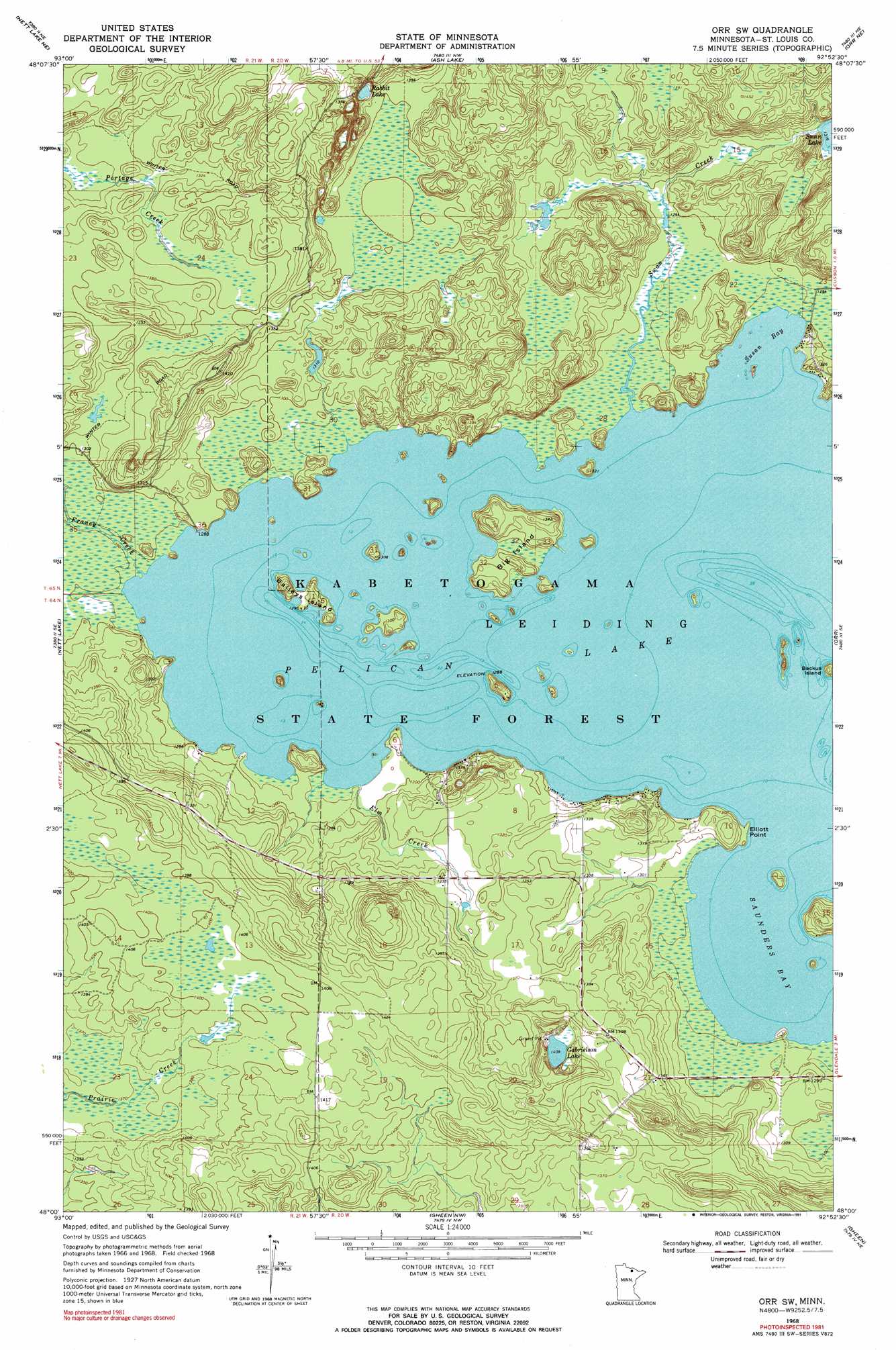
USGS Topo Quad 48092a8 - 1:24,000 scale
| Topo Map Name: | Orr Sw |
| USGS Topo Quad ID: | 48092a8 |
| Print Size: | ca. 21 1/4" wide x 27" high |
| Southeast Coordinates: | 48° N latitude / 92.875° W longitude |
| Map Center Coordinates: | 48.0625° N latitude / 92.9375° W longitude |
| U.S. State: | MN |
| Filename: | o48092a8.jpg |
| Download Map JPG Image: | Orr Sw topo map 1:24,000 scale |
| Map Type: | Topographic |
| Topo Series: | 7.5´ |
| Map Scale: | 1:24,000 |
| Source of Map Images: | United States Geological Survey (USGS) |
| Alternate Map Versions: |
Orr SW MN 1968, updated 1971 Download PDF Buy paper map Orr SW MN 1968, updated 1991 Download PDF Buy paper map Orr SW MN 2010 Download PDF Buy paper map Orr SW MN 2013 Download PDF Buy paper map Orr SW MN 2016 Download PDF Buy paper map |
1:24,000 Topo Quads surrounding Orr Sw
Ray Sw |
Ray Se |
Ash River Sw |
Ash River Se |
Marion Lake |
Nett Lake Nw |
Nett Lake Ne |
Ash Lake |
Orr Ne |
Elephant Lake |
Nett Lake Sw |
Nett Lake |
Orr Sw |
Orr |
Myrtle Lake |
Rauch |
Silverdale |
Gheen Nw |
Gheen |
Haley |
Togo |
Bear River |
Meadow Brook |
Linden Grove |
Cook |
> Back to 48092a1 at 1:100,000 scale
> Back to 48092a1 at 1:250,000 scale
> Back to U.S. Topo Maps home
Orr Sw topo map: Gazetteer
Orr Sw: Bays
Saunders Bay elevation 393m 1289′Susan Bay elevation 393m 1289′
Orr Sw: Capes
Elliott Point elevation 395m 1295′Orr Sw: Islands
Backus Island elevation 401m 1315′Baileys Island elevation 396m 1299′
Big Island elevation 393m 1289′
Orr Sw: Lakes
Gabrielson Lake elevation 429m 1407′Pelican Lake elevation 393m 1289′
Rabbit Lake elevation 410m 1345′
Orr Sw: Streams
Elm Creek elevation 393m 1289′Franey Creek elevation 393m 1289′
Swan Creek elevation 393m 1289′
Orr Sw digital topo map on disk
Buy this Orr Sw topo map showing relief, roads, GPS coordinates and other geographical features, as a high-resolution digital map file on DVD: