Jewel Basin Topo Map Montana
To zoom in, hover over the map of Jewel Basin
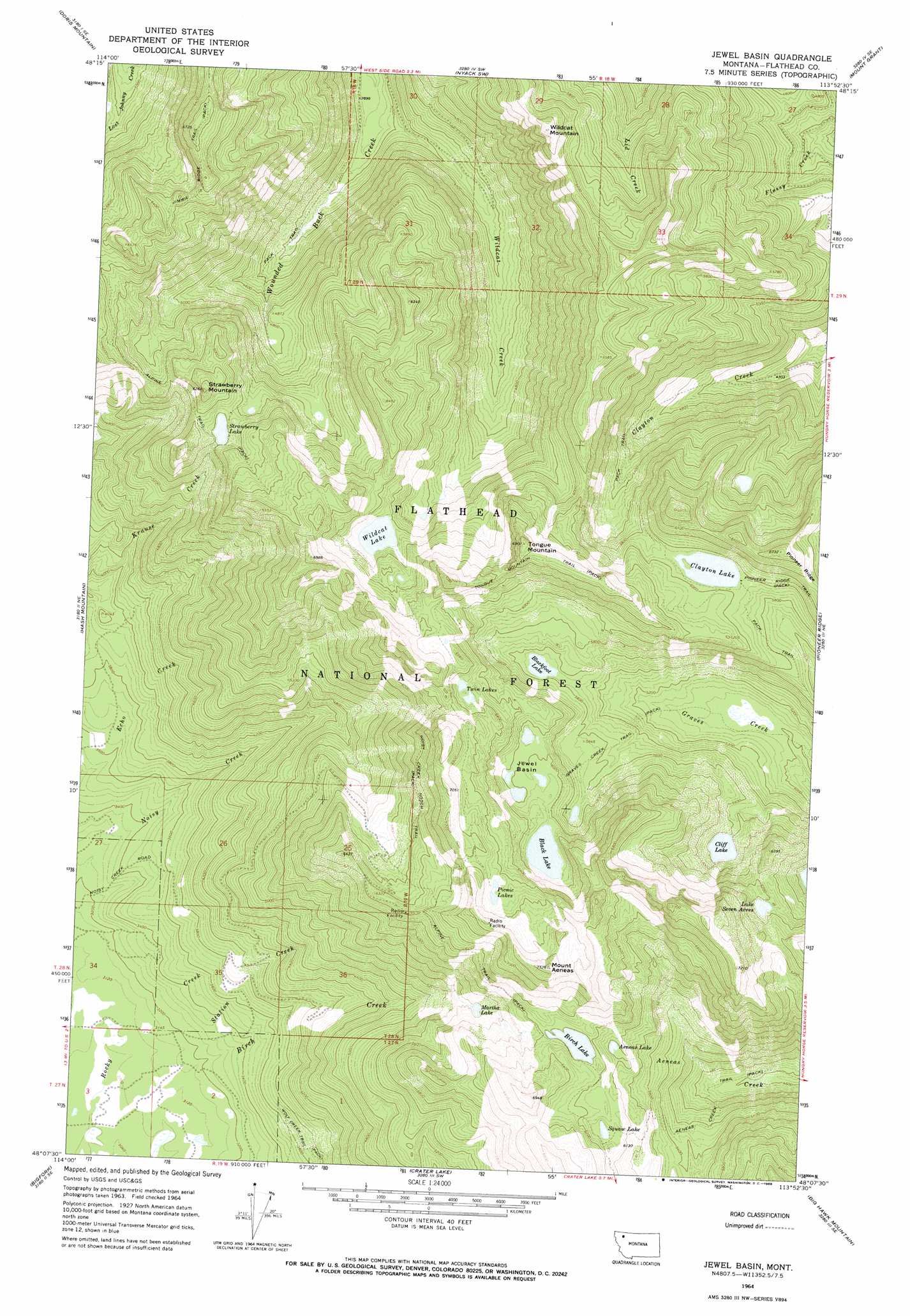
USGS Topo Quad 48113b8 - 1:24,000 scale
| Topo Map Name: | Jewel Basin |
| USGS Topo Quad ID: | 48113b8 |
| Print Size: | ca. 21 1/4" wide x 27" high |
| Southeast Coordinates: | 48.125° N latitude / 113.875° W longitude |
| Map Center Coordinates: | 48.1875° N latitude / 113.9375° W longitude |
| U.S. State: | MT |
| Filename: | o48113b8.jpg |
| Download Map JPG Image: | Jewel Basin topo map 1:24,000 scale |
| Map Type: | Topographic |
| Topo Series: | 7.5´ |
| Map Scale: | 1:24,000 |
| Source of Map Images: | United States Geological Survey (USGS) |
| Alternate Map Versions: |
Jewel Basin MT 1964, updated 1966 Download PDF Buy paper map Jewel Basin MT 1994, updated 1996 Download PDF Buy paper map Jewel Basin MT 2011 Download PDF Buy paper map Jewel Basin MT 2014 Download PDF Buy paper map |
| FStopo: | US Forest Service topo Jewel Basin is available: Download FStopo PDF Download FStopo TIF |
1:24,000 Topo Quads surrounding Jewel Basin
Columbia Falls North |
Hungry Horse |
West Glacier |
Nyack |
Stanton Lake |
Columbia Falls South |
Doris Mountain |
Nyack Sw |
Mount Grant |
Pinnacle |
Creston |
Hash Mountain |
Jewel Basin |
Pioneer Ridge |
Felix Peak |
Somers |
Bigfork |
Crater Lake |
Big Hawk Mountain |
Quintonkon |
Rollins |
Woods Bay |
Yew Creek |
Swan Lake |
Connor Creek |
> Back to 48113a1 at 1:100,000 scale
> Back to 48112a1 at 1:250,000 scale
> Back to U.S. Topo Maps home
Jewel Basin topo map: Gazetteer
Jewel Basin: Basins
Jewel Basin elevation 1843m 6046′Jewel Basin: Lakes
Aeneas Lake elevation 1827m 5994′Birch Lake elevation 1888m 6194′
Black Lake elevation 1848m 6062′
Blackfoot Lake elevation 1688m 5538′
Clayton Lake elevation 1812m 5944′
Cliff Lake elevation 1702m 5583′
In-thlam-keh Lake elevation 1839m 6033′
Lake Seven Acres elevation 1872m 6141′
Martha Lake elevation 1703m 5587′
Picnic Lakes elevation 2025m 6643′
Strawberry Lake elevation 1702m 5583′
Twin Lakes elevation 1923m 6309′
Wildcat Lake elevation 1775m 5823′
Jewel Basin: Streams
Station Creek elevation 938m 3077′Wildcat Creek elevation 1188m 3897′
Jewel Basin: Summits
Mount Aeneas elevation 2279m 7477′Strawberry Mountain elevation 1891m 6204′
Tongue Mountain elevation 2083m 6833′
Wildcat Mountain elevation 2001m 6564′
Jewel Basin: Trails
Aeneas Creek Trail elevation 1456m 4776′Graves Creek Trail elevation 1693m 5554′
Jimmie Ridge Trail elevation 1988m 6522′
Noisy Creek Notch Trail elevation 1937m 6354′
Pioneer Ridge Trail elevation 1838m 6030′
Tongue Mountain Trail elevation 2050m 6725′
Jewel Basin digital topo map on disk
Buy this Jewel Basin topo map showing relief, roads, GPS coordinates and other geographical features, as a high-resolution digital map file on DVD: