Columbia Falls North Topo Map Montana
To zoom in, hover over the map of Columbia Falls North
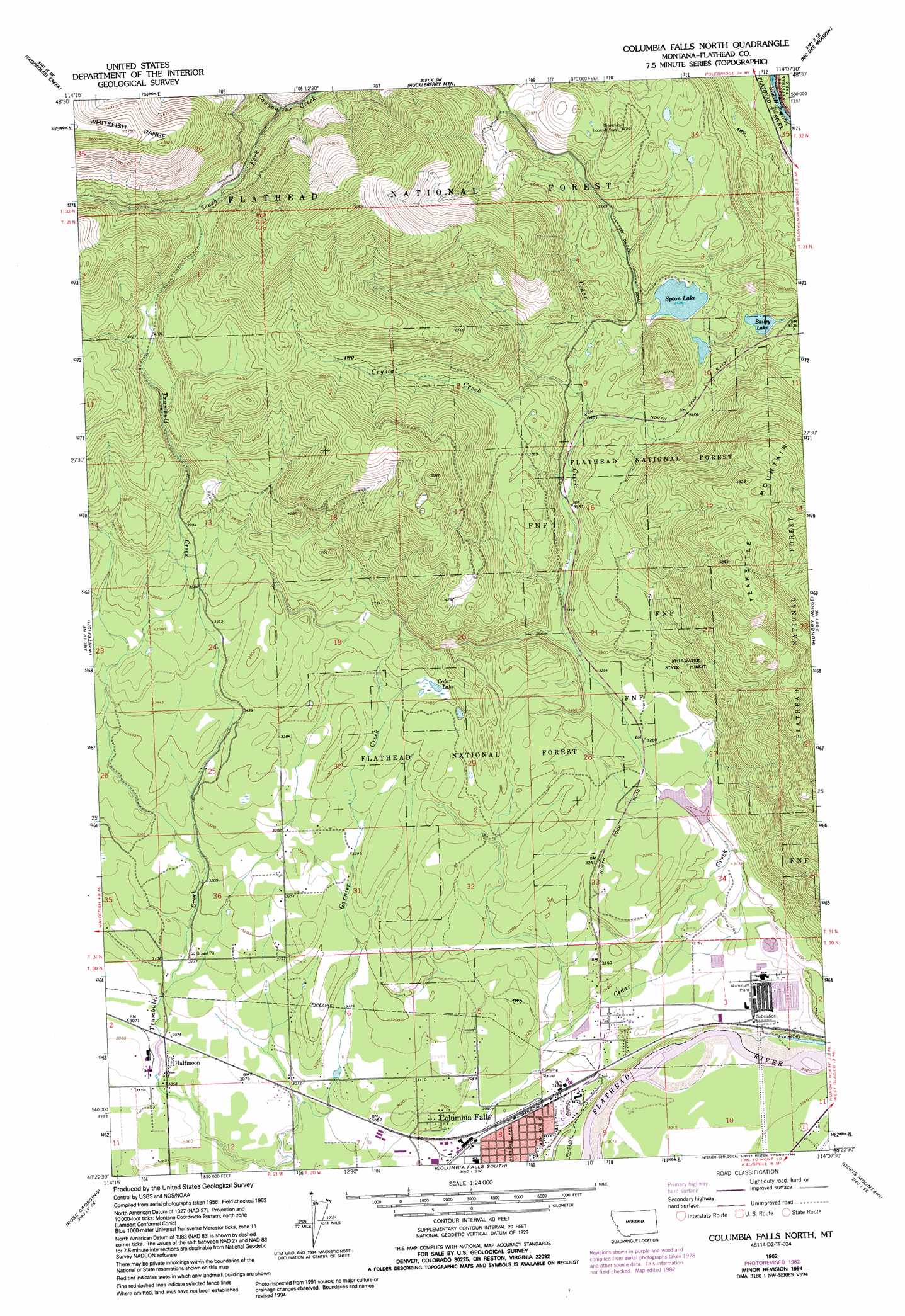
USGS Topo Quad 48114d2 - 1:24,000 scale
| Topo Map Name: | Columbia Falls North |
| USGS Topo Quad ID: | 48114d2 |
| Print Size: | ca. 21 1/4" wide x 27" high |
| Southeast Coordinates: | 48.375° N latitude / 114.125° W longitude |
| Map Center Coordinates: | 48.4375° N latitude / 114.1875° W longitude |
| U.S. State: | MT |
| Filename: | o48114d2.jpg |
| Download Map JPG Image: | Columbia Falls North topo map 1:24,000 scale |
| Map Type: | Topographic |
| Topo Series: | 7.5´ |
| Map Scale: | 1:24,000 |
| Source of Map Images: | United States Geological Survey (USGS) |
| Alternate Map Versions: |
Columbia Falls North MT 1962, updated 1965 Download PDF Buy paper map Columbia Falls North MT 1962, updated 1975 Download PDF Buy paper map Columbia Falls North MT 1962, updated 1983 Download PDF Buy paper map Columbia Falls North MT 1962, updated 1995 Download PDF Buy paper map Columbia Falls North MT 1994, updated 1997 Download PDF Buy paper map Columbia Falls North MT 2011 Download PDF Buy paper map Columbia Falls North MT 2014 Download PDF Buy paper map |
| FStopo: | US Forest Service topo Columbia Falls North is available: Download FStopo PDF Download FStopo TIF |
1:24,000 Topo Quads surrounding Columbia Falls North
Moose Peak |
Cyclone Lake |
Demers Ridge |
Camas Ridge West |
Camas Ridge East |
Werner Peak |
Skookoleel Creek |
Huckleberry Mountain |
Mcgee Meadow |
Lake Mcdonald West |
Beaver Lake |
Whitefish |
Columbia Falls North |
Hungry Horse |
West Glacier |
Rhodes |
Rose Crossing |
Columbia Falls South |
Doris Mountain |
Nyack Sw |
Blue Grass Ridge |
Kalispell |
Creston |
Hash Mountain |
Jewel Basin |
> Back to 48114a1 at 1:100,000 scale
> Back to 48114a1 at 1:250,000 scale
> Back to U.S. Topo Maps home
Columbia Falls North topo map: Gazetteer
Columbia Falls North: Dams
Cedar Creek Dam elevation 954m 3129′Columbia Falls North: Lakes
Bailey Lake elevation 994m 3261′Cedar Lake elevation 1036m 3398′
Spoon Lake elevation 1049m 3441′
Columbia Falls North: Populated Places
Conkelley elevation 941m 3087′Country Estates Mobile Home Park elevation 954m 3129′
Half Moon Mobile Home Park elevation 934m 3064′
Halfmoon elevation 935m 3067′
Columbia Falls North: Springs
Schafer Springs elevation 986m 3234′Columbia Falls North: Streams
Cedar Creek elevation 939m 3080′Crystal Creek elevation 1081m 3546′
South Fork Canyon Creek elevation 1203m 3946′
Columbia Falls North: Wells
30N20W02CB__01 Well elevation 951m 3120′30N20W03DA__01 Well elevation 944m 3097′
30N20W03DDDA01 Well elevation 919m 3015′
30N20W03DDDA02 Well elevation 919m 3015′
30N20W05CD__01 Well elevation 951m 3120′
30N20W06CB__01 Well elevation 973m 3192′
30N20W07DA__01 Well elevation 936m 3070′
30N20W08CA__01 Well elevation 939m 3080′
30N20W08DAD_01 Well elevation 941m 3087′
30N20W09CBCB01 Well elevation 921m 3021′
30N21W11AA__01 Well elevation 934m 3064′
31N20W31CCBA01 Well elevation 999m 3277′
31N21W25AD__01 Well elevation 1044m 3425′
Columbia Falls North digital topo map on disk
Buy this Columbia Falls North topo map showing relief, roads, GPS coordinates and other geographical features, as a high-resolution digital map file on DVD: