Robinson Mountain Topo Map Montana
To zoom in, hover over the map of Robinson Mountain
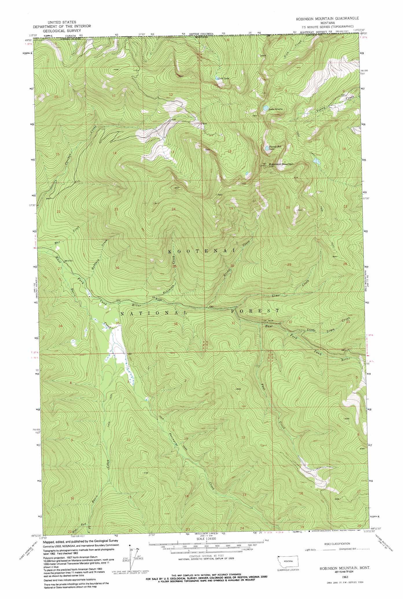
USGS Topo Quad 48115h4 - 1:24,000 scale
| Topo Map Name: | Robinson Mountain |
| USGS Topo Quad ID: | 48115h4 |
| Print Size: | ca. 21 1/4" wide x 27" high |
| Southeast Coordinates: | 48.875° N latitude / 115.375° W longitude |
| Map Center Coordinates: | 48.9375° N latitude / 115.4375° W longitude |
| U.S. State: | MT |
| Filename: | o48115h4.jpg |
| Download Map JPG Image: | Robinson Mountain topo map 1:24,000 scale |
| Map Type: | Topographic |
| Topo Series: | 7.5´ |
| Map Scale: | 1:24,000 |
| Source of Map Images: | United States Geological Survey (USGS) |
| Alternate Map Versions: |
Robinson Mountain MT 1963, updated 1966 Download PDF Buy paper map Robinson Mountain MT 1963, updated 1991 Download PDF Buy paper map Robinson Mountain MT 1997, updated 2000 Download PDF Buy paper map Robinson Mountain MT 2011 Download PDF Buy paper map Robinson Mountain MT 2014 Download PDF Buy paper map |
| FStopo: | US Forest Service topo Robinson Mountain is available: Download FStopo PDF Download FStopo TIF |
1:24,000 Topo Quads surrounding Robinson Mountain
Bonnet Top |
Mount Henry |
Robinson Mountain |
Red Mountain |
Rexford |
Yaak |
Lost Horse Mountain |
Boulder Lakes |
Webb Mountain |
Beartrap Mountain |
Flatiron Mountain |
Pink Mountain |
Parsnip Mountain |
Inch Mountain |
Mcguire Mountain |
> Back to 48115e1 at 1:100,000 scale
> Back to 48114a1 at 1:250,000 scale
> Back to U.S. Topo Maps home
Robinson Mountain topo map: Gazetteer
Robinson Mountain: Lakes
Gold Lake elevation 1815m 5954′Lake Geneva elevation 1995m 6545′
Plumb Bob Lake elevation 2016m 6614′
Robinson Mountain: Streams
Basin Creek elevation 1129m 3704′Bridge Creek elevation 1237m 4058′
East Fork Basin Creek elevation 1355m 4445′
Fast Creek elevation 1303m 4274′
Gold Creek elevation 1814m 5951′
Hubbard Creek elevation 1143m 3750′
Lime Creek elevation 1267m 4156′
Little Lime Creek elevation 1361m 4465′
Max Creek elevation 1116m 3661′
Porcupine Creek elevation 1181m 3874′
Robinson Creek elevation 1192m 3910′
Sink Creek elevation 1758m 5767′
West Fork Basin Creek elevation 1349m 4425′
Robinson Mountain: Summits
Robinson Mountain elevation 2298m 7539′Robinson Mountain digital topo map on disk
Buy this Robinson Mountain topo map showing relief, roads, GPS coordinates and other geographical features, as a high-resolution digital map file on DVD: