Boulder Lakes Topo Map Montana
To zoom in, hover over the map of Boulder Lakes
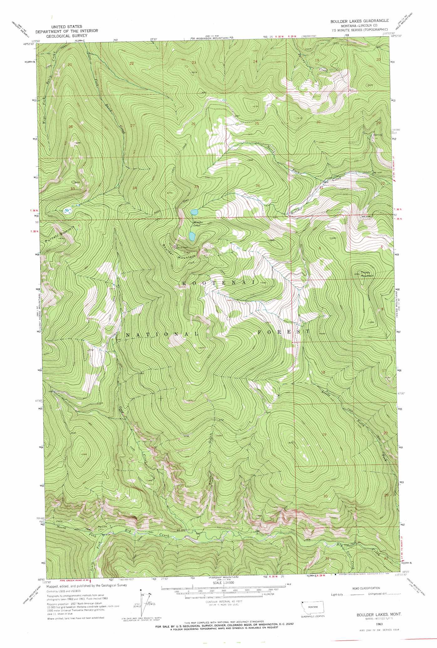
USGS Topo Quad 48115g4 - 1:24,000 scale
| Topo Map Name: | Boulder Lakes |
| USGS Topo Quad ID: | 48115g4 |
| Print Size: | ca. 21 1/4" wide x 27" high |
| Southeast Coordinates: | 48.75° N latitude / 115.375° W longitude |
| Map Center Coordinates: | 48.8125° N latitude / 115.4375° W longitude |
| U.S. State: | MT |
| Filename: | o48115g4.jpg |
| Download Map JPG Image: | Boulder Lakes topo map 1:24,000 scale |
| Map Type: | Topographic |
| Topo Series: | 7.5´ |
| Map Scale: | 1:24,000 |
| Source of Map Images: | United States Geological Survey (USGS) |
| Alternate Map Versions: |
Boulder Lakes MT 1963, updated 1966 Download PDF Buy paper map Boulder Lakes MT 1997, updated 2000 Download PDF Buy paper map Boulder Lakes MT 2011 Download PDF Buy paper map Boulder Lakes MT 2014 Download PDF Buy paper map |
| FStopo: | US Forest Service topo Boulder Lakes is available: Download FStopo PDF Download FStopo TIF |
1:24,000 Topo Quads surrounding Boulder Lakes
Bonnet Top |
Mount Henry |
Robinson Mountain |
Red Mountain |
Rexford |
Yaak |
Lost Horse Mountain |
Boulder Lakes |
Webb Mountain |
Beartrap Mountain |
Flatiron Mountain |
Pink Mountain |
Parsnip Mountain |
Inch Mountain |
Mcguire Mountain |
Turner Mountain |
Gold Hill |
Banfield Mountain |
Ural |
Volcour |
> Back to 48115e1 at 1:100,000 scale
> Back to 48114a1 at 1:250,000 scale
> Back to U.S. Topo Maps home
Boulder Lakes topo map: Gazetteer
Boulder Lakes: Falls
Little North Fork Falls elevation 933m 3061′Boulder Lakes: Lakes
Boulder Lakes elevation 1850m 6069′Boulder Lakes: Streams
Good Creek elevation 898m 2946′North Fork Big Creek elevation 943m 3093′
North Fork Boulder Creek elevation 1470m 4822′
South Fork Big Creek elevation 943m 3093′
Steep Creek elevation 859m 2818′
Boulder Lakes: Summits
Boulder Mountain elevation 2148m 7047′Purcell Summit elevation 2052m 6732′
Thirsty Mountain elevation 1907m 6256′
Boulder Lakes: Valleys
Knife Gulch elevation 919m 3015′Boulder Lakes digital topo map on disk
Buy this Boulder Lakes topo map showing relief, roads, GPS coordinates and other geographical features, as a high-resolution digital map file on DVD: