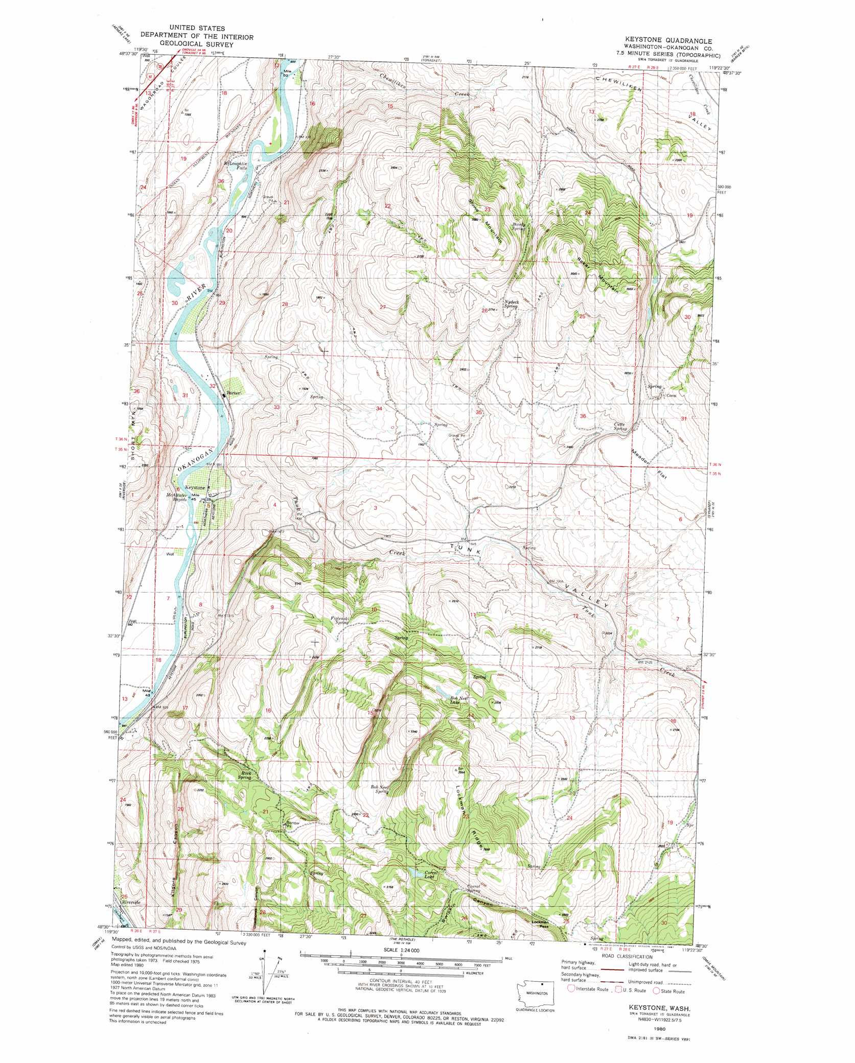
Keystone Topo Map Washington
To zoom in, hover over the map of Keystone
USGS Topo Quad 48119e4 - 1:24,000 scale
| Topo Map Name: | Keystone |
| USGS Topo Quad ID: | 48119e4 |
| Print Size: | ca. 21 1/4" wide x 27" high |
| Southeast Coordinates: | 48.5° N latitude / 119.375° W longitude |
| Map Center Coordinates: | 48.5625° N latitude / 119.4375° W longitude |
| U.S. State: | WA |
| Filename: | o48119e4.jpg |
| Download Map JPG Image: | Keystone topo map 1:24,000 scale |
| Map Type: | Topographic |
| Topo Series: | 7.5´ |
| Map Scale: | 1:24,000 |
| Source of Map Images: | United States Geological Survey (USGS) |
| Alternate Map Versions: |
Keystone WA 1980, updated 1981 Download PDF Buy paper map Keystone WA 2011 Download PDF Buy paper map Keystone WA 2014 Download PDF Buy paper map |
1:24,000 Topo Quads surrounding Keystone
Loomis |
Enterprise |
Ellisforde |
Burge Mountain |
Havillah |
Blue Goat Mountain |
Aeneas Lake |
Tonasket |
Barker Mountain |
Cayuse Mountain |
Conconully East |
Riverside |
Keystone |
Synarep |
Tunk Mountain |
Ruby Hill |
Omak |
The Pothole |
Omak Mountain |
Crawfish Lake |
Malott |
Okanogan |
Omak Lake |
Camp Seven |
Disautel |
> Back to 48119e1 at 1:100,000 scale
> Back to 48118a1 at 1:250,000 scale
> Back to U.S. Topo Maps home
Keystone topo map: Gazetteer
Keystone: Falls
McLoughlin Falls elevation 263m 862′Keystone: Flats
Meader Flat elevation 821m 2693′Keystone: Gaps
Lockman Pass elevation 982m 3221′Keystone: Lakes
Bob Neal Lake elevation 829m 2719′Corral Lake elevation 903m 2962′
Keystone: Populated Places
Barker elevation 267m 875′Keystone elevation 265m 869′
Keystone: Rapids
McAllister Rapids elevation 261m 856′Keystone: Ridges
Lockman Ridge elevation 1078m 3536′Keystone: Springs
Bob Neal Spring elevation 830m 2723′Corral Spring elevation 942m 3090′
Cutts Spring elevation 758m 2486′
Figlenski Spring elevation 695m 2280′
Hardy Spring elevation 825m 2706′
Nydeck Spring elevation 817m 2680′
Keystone: Streams
Tunk Creek elevation 261m 856′Keystone: Summits
Baker Mountain elevation 1022m 3353′Stowe Mountain elevation 1026m 3366′
Keystone: Valleys
Chewiliken Valley elevation 750m 2460′Kilgore Canyon elevation 327m 1072′
Tunk Valley elevation 261m 856′
Keystone digital topo map on disk
Buy this Keystone topo map showing relief, roads, GPS coordinates and other geographical features, as a high-resolution digital map file on DVD: