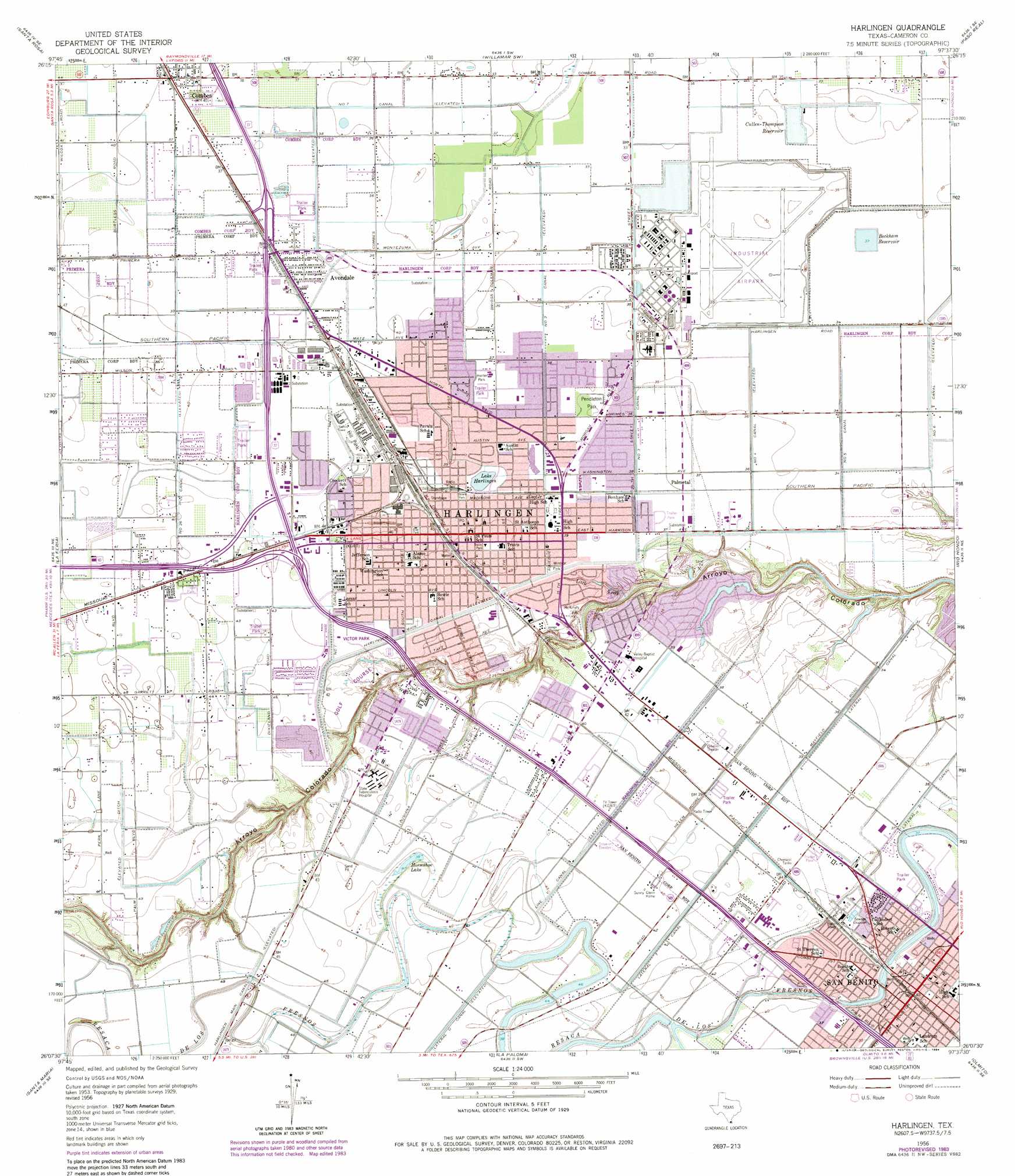
Harlingen Topo Map Texas
To zoom in, hover over the map of Harlingen
USGS Topo Quad 26097b6 - 1:24,000 scale
| Topo Map Name: | Harlingen |
| USGS Topo Quad ID: | 26097b6 |
| Print Size: | ca. 21 1/4" wide x 27" high |
| Southeast Coordinates: | 26.125° N latitude / 97.625° W longitude |
| Map Center Coordinates: | 26.1875° N latitude / 97.6875° W longitude |
| U.S. State: | TX |
| Filename: | o26097b6.jpg |
| Download Map JPG Image: | Harlingen topo map 1:24,000 scale |
| Map Type: | Topographic |
| Topo Series: | 7.5´ |
| Map Scale: | 1:24,000 |
| Source of Map Images: | United States Geological Survey (USGS) |
| Alternate Map Versions: |
Harlingen TX 1929 Download PDF Buy paper map Harlingen TX 1956, updated 1959 Download PDF Buy paper map Harlingen TX 1956, updated 1971 Download PDF Buy paper map Harlingen TX 1956, updated 1984 Download PDF Buy paper map Harlingen TX 2010 Download PDF Buy paper map Harlingen TX 2013 Download PDF Buy paper map Harlingen TX 2016 Download PDF Buy paper map |
1:24,000 Topo Quads surrounding Harlingen
Lasara |
Raymondville |
San Perlita South |
Willamar |
Hawk Island |
Edcouch |
Santa Rosa |
Willamar Sw |
Paso Real |
La Leona |
Mercedes |
La Feria |
Harlingen |
Rio Hondo |
Laguna Atascosa |
Progreso |
Santa Maria |
La Paloma |
Olmito |
Los Fresnos |
West Brownsville |
East Brownsville |
> Back to 26097a1 at 1:100,000 scale
> Back to 26096a1 at 1:250,000 scale
> Back to U.S. Topo Maps home
Harlingen topo map: Gazetteer
Harlingen: Airports
Farmers Co-op Airport elevation 13m 42′Rio Grande Valley International Airport elevation 9m 29′
Shofner Farms Airport elevation 14m 45′
Valley Baptist Medical Center elevation 11m 36′
Harlingen: Canals
Harlingen Main Canal elevation 15m 49′Lateral R Canal elevation 11m 36′
Lateral T Canal elevation 11m 36′
Line V Canal elevation 12m 39′
Number Five Canal elevation 10m 32′
Number Four Canal elevation 11m 36′
Number One Canal elevation 12m 39′
Number Seven Canal elevation 9m 29′
Number Six Canal elevation 8m 26′
Number Three Canal elevation 11m 36′
Number Twentysix Canal elevation 14m 45′
Number Two Canal elevation 11m 36′
Harlingen: Dams
City of Harlingen Dam elevation 12m 39′Cullen-Thompson Dam elevation 9m 29′
Harlingen: Lakes
Horseshoe Lake elevation 14m 45′Lake Harlingen elevation 11m 36′
Harlingen: Parks
Bonham Park elevation 10m 32′Botts Park elevation 11m 36′
Bowie Park elevation 12m 39′
Bowie Park elevation 13m 42′
Diaz Park elevation 14m 45′
Dixieland Park elevation 13m 42′
Dixieland Park elevation 13m 42′
Fair Park elevation 12m 39′
Fair Park elevation 12m 39′
Harlingen Field (historical) elevation 12m 39′
Hill Park elevation 12m 39′
Hunter Park elevation 11m 36′
Kenedy Park elevation 12m 39′
Landrum Park elevation 10m 32′
Liberty Gardens Park elevation 13m 42′
Liberty Park elevation 12m 39′
Marine Military Academy Stadium elevation 9m 29′
Mc Cullough Park elevation 3m 9′
McCullough Park elevation 7m 22′
McKelvey Park elevation 11m 36′
Pendleton Park elevation 11m 36′
Ramsey Park elevation 7m 22′
Ramsey Park elevation 4m 13′
Sam Houston Park elevation 12m 39′
Sam Houston Park elevation 12m 39′
San Benito City Park elevation 10m 32′
Travis Park elevation 13m 42′
Victor Park elevation 12m 39′
Victor Park elevation 12m 39′
Windsor Park elevation 12m 39′
Wood Park elevation 9m 29′
Wood Park elevation 6m 19′
Harlingen: Populated Places
Avondale elevation 11m 36′Bonnaville Terrace Colonia elevation 11m 36′
Combes elevation 12m 39′
Combes Colonia elevation 11m 36′
Fred Adams Colonia elevation 11m 36′
Harlingen elevation 12m 39′
Juarez Colonia elevation 12m 39′
Las Palmas Colonia elevation 12m 39′
Leal Colonia elevation 12m 39′
Los Ranchitos Colonia elevation 12m 39′
Palacios Estates Colonia elevation 12m 39′
Palmetal elevation 11m 36′
San Benito elevation 11m 36′
Santa Elena Colonia elevation 9m 29′
South Ratliff Street Colonia elevation 13m 42′
Harlingen: Reservoirs
Beckham Reservoir elevation 10m 32′City of Harlingen Reservoir elevation 12m 39′
Cullen-Thompson Reservoir elevation 9m 29′
Harlingen: Streams
Little Creek elevation 9m 29′Harlingen: Trails
Arroyo Hike and Bike Trail elevation 11m 36′Harlingen digital topo map on disk
Buy this Harlingen topo map showing relief, roads, GPS coordinates and other geographical features, as a high-resolution digital map file on DVD: