Matanzas Inlet Topo Map Florida
To zoom in, hover over the map of Matanzas Inlet
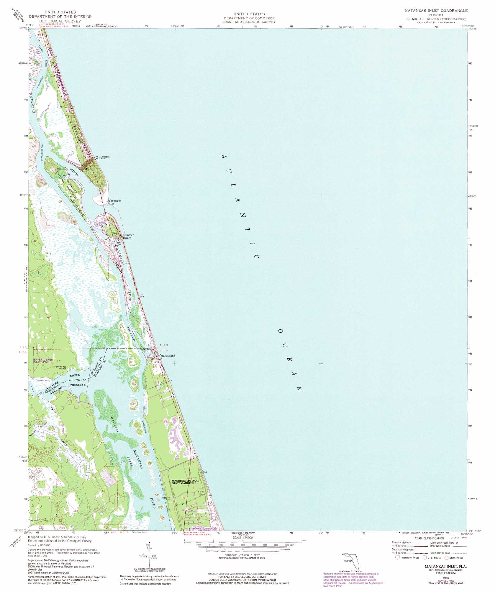
USGS Topo Quad 29081f2 - 1:24,000 scale
| Topo Map Name: | Matanzas Inlet |
| USGS Topo Quad ID: | 29081f2 |
| Print Size: | ca. 21 1/4" wide x 27" high |
| Southeast Coordinates: | 29.625° N latitude / 81.125° W longitude |
| Map Center Coordinates: | 29.6875° N latitude / 81.1875° W longitude |
| U.S. State: | FL |
| Filename: | O29081F2.jpg |
| Download Map JPG Image: | Matanzas Inlet topo map 1:24,000 scale |
| Map Type: | Topographic |
| Topo Series: | 7.5´ |
| Map Scale: | 1:24,000 |
| Source of Map Images: | United States Geological Survey (USGS) |
| Alternate Map Versions: |
Matanzas Inlet FL 1956, updated 1960 Download PDF Buy paper map Matanzas Inlet FL 1956, updated 1972 Download PDF Buy paper map Matanzas Inlet FL 1956, updated 1990 Download PDF Buy paper map Matanzas Inlet FL 1956, updated 1992 Download PDF Buy paper map Matanzas Inlet FL 2012 Download PDF Buy paper map Matanzas Inlet FL 2015 Download PDF Buy paper map |
1:24,000 Topo Quads surrounding Matanzas Inlet
Bakersville |
Saint Augustine |
|||
Elkton |
Saint Augustine Beach |
|||
Spuds |
Dinner Island Ne |
Matanzas Inlet |
||
Dinner Island |
Espanola |
Beverly Beach |
||
Saint Johns Park |
Bunnell |
Flagler Beach West |
Flagler Beach East |
> Back to 29081e1 at 1:100,000 scale
> Back to 29080a1 at 1:250,000 scale
> Back to U.S. Topo Maps home
Matanzas Inlet topo map: Gazetteer
Matanzas Inlet: Bends
Devils Elbow elevation 0m 0′Matanzas Inlet: Bridges
Claude Varne Bridge elevation 0m 0′Matanzas Inlet: Capes
Hemming Point elevation 1m 3′Matanzas Inlet: Channels
Matanzas Inlet elevation 0m 0′Matanzas Inlet: Flats
Pellicer Flats elevation 0m 0′Matanzas Inlet: Islands
Rattlesnake Island elevation 1m 3′Matanzas Inlet: Lakes
Lake Rayonier One elevation 6m 19′Matanzas Inlet: Parks
Faver-Dykes State Park elevation 3m 9′Fort Matanzas National Monument elevation 1m 3′
Pellicer Creek Aquatic Preserve elevation 0m 0′
Washington Oaks Gardens State Park elevation 2m 6′
Matanzas Inlet: Populated Places
Fort Matanzas elevation 0m 0′Marineland elevation 2m 6′
Summer Haven elevation 1m 3′
Matanzas Inlet: Streams
Hominy Branch elevation 2m 6′Pellicer Creek elevation 0m 0′
Styles Creek elevation 0m 0′
Matanzas Inlet digital topo map on disk
Buy this Matanzas Inlet topo map showing relief, roads, GPS coordinates and other geographical features, as a high-resolution digital map file on DVD: