Vernon Topo Map Florida
To zoom in, hover over the map of Vernon
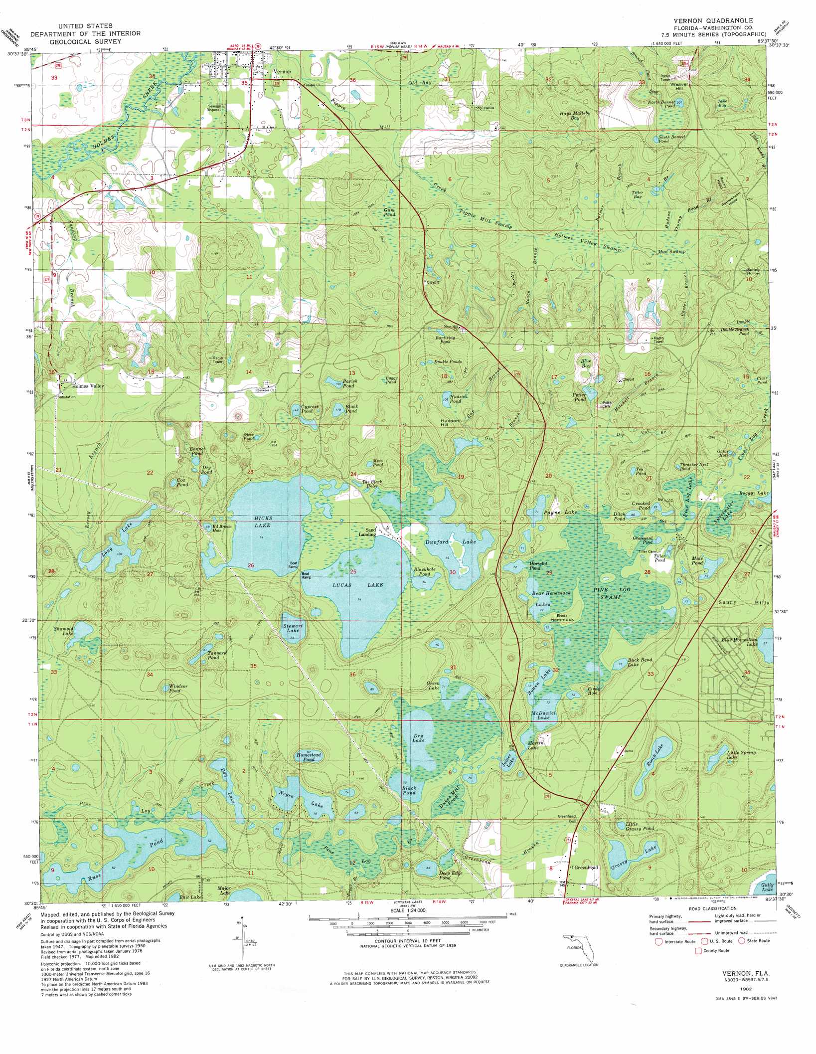
USGS Topo Quad 30085e6 - 1:24,000 scale
| Topo Map Name: | Vernon |
| USGS Topo Quad ID: | 30085e6 |
| Print Size: | ca. 21 1/4" wide x 27" high |
| Southeast Coordinates: | 30.5° N latitude / 85.625° W longitude |
| Map Center Coordinates: | 30.5625° N latitude / 85.6875° W longitude |
| U.S. State: | FL |
| Filename: | O30085E6.jpg |
| Download Map JPG Image: | Vernon topo map 1:24,000 scale |
| Map Type: | Topographic |
| Topo Series: | 7.5´ |
| Map Scale: | 1:24,000 |
| Source of Map Images: | United States Geological Survey (USGS) |
| Alternate Map Versions: |
Vernon FL 1950, updated 1963 Download PDF Buy paper map Vernon FL 1950, updated 1976 Download PDF Buy paper map Vernon FL 1951 Download PDF Buy paper map Vernon FL 2012 Download PDF Buy paper map Vernon FL 2015 Download PDF Buy paper map |
1:24,000 Topo Quads surrounding Vernon
Prosperity |
Caryville |
Bonifay |
Chipley |
Cottondale West |
Ponce De Leon |
Hinsons Crossroads |
Poplar Head |
Wausau |
Alford |
Redbay |
Millers Ferry |
Vernon |
Gap Lake |
Compass Lake |
Bruce |
Red Head |
Crystal Lake |
Bennett |
Fountain |
Seminole Hills |
West Bay |
Southport |
Bayhead |
Youngstown |
> Back to 30085e1 at 1:100,000 scale
> Back to 30084a1 at 1:250,000 scale
> Back to U.S. Topo Maps home
Vernon topo map: Gazetteer
Vernon: Basins
Spring Hollow elevation 59m 193′Vernon: Bays
Gator Hole elevation 30m 98′Old Bay elevation 15m 49′
Tiller Bay elevation 38m 124′
Vernon: Lakes
Baptizing Pond elevation 47m 154′Bear Hammock Lakes elevation 22m 72′
Black Pond elevation 22m 72′
Black Pond elevation 36m 118′
Blackhole Pond elevation 22m 72′
Blue Homestead Lake elevation 20m 65′
Boggy Lake elevation 26m 85′
Bonnet Pond elevation 28m 91′
Bowen Lake elevation 22m 72′
Buck Bend Lake elevation 22m 72′
Chain Lake elevation 23m 75′
Cindy Hole elevation 23m 75′
Clair Pond elevation 38m 124′
Cox Pond elevation 26m 85′
Crooked Pond elevation 23m 75′
Cypress Pond elevation 45m 147′
Deep Edge Pond elevation 26m 85′
Ditch Pond elevation 26m 85′
Dog Lake elevation 20m 65′
Double Branch Pond elevation 47m 154′
Double Ponds elevation 38m 124′
Dry Lake elevation 22m 72′
Dry Pond elevation 28m 91′
Dunford Lake elevation 22m 72′
Dykes Mill Pond elevation 22m 72′
Grassy Lake elevation 22m 72′
Graveyard Pond elevation 24m 78′
Green Lake elevation 22m 72′
Hicks Lake elevation 22m 72′
Homestead Pond elevation 28m 91′
Horselot Pond elevation 22m 72′
Hudson Pond elevation 32m 104′
Joiner Lake elevation 21m 68′
Little Grassy Pond elevation 22m 72′
Little Spring Lake elevation 23m 75′
Long Lake elevation 32m 104′
Lucas Lake elevation 22m 72′
Martin Lake elevation 22m 72′
McDaniel Lake elevation 22m 72′
Moss Pond elevation 19m 62′
Mule Pond elevation 23m 75′
North Bonnet Pond elevation 63m 206′
Otter Pond elevation 35m 114′
Parish Pond elevation 46m 150′
Parrish Pond elevation 46m 150′
Payne Lake elevation 22m 72′
Pine Log Lake elevation 26m 85′
Potter Pond elevation 37m 121′
Roach Lake elevation 29m 95′
Russ Pond elevation 19m 62′
Shumold Lake elevation 26m 85′
South Bonnet Pond elevation 63m 206′
Stewart Lake elevation 27m 88′
Sweetwater Lake elevation 26m 85′
Tanyard Pond elevation 24m 78′
Tea Pond elevation 35m 114′
The Black Holes elevation 25m 82′
Thrasher Nest Pond elevation 25m 82′
Tiller Pond elevation 23m 75′
Windsor Pond elevation 31m 101′
Vernon: Populated Places
Greenhead elevation 44m 144′Holmes Valley elevation 58m 190′
Macom elevation 59m 193′
Smyrna elevation 23m 75′
Sylvania elevation 33m 108′
Vernon elevation 13m 42′
Vernon: Streams
Boggy Branch elevation 21m 68′Carter Branch elevation 33m 108′
Dip Vat Branch elevation 27m 88′
Fanning Branch elevation 9m 29′
Gap Branch elevation 26m 85′
Gin Branch elevation 22m 72′
Greenhead Branch elevation 23m 75′
Hudson Branch elevation 33m 108′
Kersey Branch elevation 33m 108′
Mitchell Branch elevation 28m 91′
Palmer Branch elevation 27m 88′
Roach Branch elevation 27m 88′
Thorny Head Branch elevation 33m 108′
Vernon: Summits
Hudson Hill elevation 53m 173′Weaver Hill elevation 84m 275′
Vernon: Swamps
Blue Bay elevation 48m 157′Boggy Pond elevation 57m 187′
Gum Pond elevation 19m 62′
Hays Maltsby Bay elevation 44m 144′
Holmes Valley Swamp elevation 26m 85′
Jane Bay elevation 57m 187′
Mud Swamp elevation 32m 104′
Pine Log Swamp elevation 22m 72′
Pippin Mill Swamp elevation 23m 75′
Vernon: Valleys
Rattlesnake Head elevation 51m 167′Rocky Head elevation 53m 173′
Vernon digital topo map on disk
Buy this Vernon topo map showing relief, roads, GPS coordinates and other geographical features, as a high-resolution digital map file on DVD:
Gulf Coast (LA, MS, AL, FL) & Southwestern Georgia
Buy digital topo maps: Gulf Coast (LA, MS, AL, FL) & Southwestern Georgia
 & Southwestern Georgia map DVD")