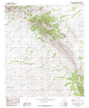
Black Diamond Peak Topo Map Arizona
To zoom in, hover over the map of Black Diamond Peak
USGS Topo Quad 31109g8 - 1:24,000 scale
| Topo Map Name: | Black Diamond Peak |
| USGS Topo Quad ID: | 31109g8 |
| Print Size: | ca. 21 1/4" wide x 27" high |
| Southeast Coordinates: | 31.75° N latitude / 109.875° W longitude |
| Map Center Coordinates: | 31.8125° N latitude / 109.9375° W longitude |
| U.S. State: | AZ |
| Filename: | o31109g8.jpg |
| Download Map JPG Image: | Black Diamond Peak topo map 1:24,000 scale |
| Map Type: | Topographic |
| Topo Series: | 7.5´ |
| Map Scale: | 1:24,000 |
| Source of Map Images: | United States Geological Survey (USGS) |
| Alternate Map Versions: |
Black Diamond Peak AZ 1985, updated 1985 Download PDF Buy paper map Black Diamond Peak AZ 1985, updated 1985 Download PDF Buy paper map Black Diamond Peak AZ 1996, updated 2002 Download PDF Buy paper map Black Diamond Peak AZ 2012 Download PDF Buy paper map Black Diamond Peak AZ 2014 Download PDF Buy paper map |
| FStopo: | US Forest Service topo Black Diamond Peak is available: Download FStopo PDF Download FStopo TIF |
1:24,000 Topo Quads surrounding Black Diamond Peak
> Back to 31109e1 at 1:100,000 scale
> Back to 31108a1 at 1:250,000 scale
> Back to U.S. Topo Maps home
Black Diamond Peak topo map: Gazetteer
Black Diamond Peak: Gaps
Middlemarch Pass elevation 1808m 5931′OK Notch elevation 1931m 6335′
South Pass elevation 1595m 5232′
Black Diamond Peak: Mines
Escapule Mine elevation 2048m 6719′Festerling Mine elevation 1790m 5872′
Standard Tungsten Mine elevation 1771m 5810′
Black Diamond Peak: Populated Places
Black Diamond elevation 1566m 5137′Black Diamond Peak: Reservoirs
Black Diamond Tank elevation 1551m 5088′Black Tank elevation 1584m 5196′
Dragoon Camp Tank elevation 1668m 5472′
Forest Tank elevation 1508m 4947′
Gordon Tank elevation 1647m 5403′
Black Diamond Peak: Springs
Buckshot Spring elevation 1554m 5098′Caslink Spring elevation 1452m 4763′
Diamond Spring elevation 1683m 5521′
Gilda Spring elevation 1783m 5849′
Goodrich Spring elevation 1589m 5213′
Granite Spring elevation 1587m 5206′
Majo Spring elevation 1583m 5193′
Neely Spring elevation 1570m 5150′
Pinon Spring elevation 1703m 5587′
South Pass Spring elevation 1609m 5278′
Walnut Springs elevation 1586m 5203′
Black Diamond Peak: Summits
Black Diamond Peak elevation 2160m 7086′Sheepshead elevation 0m 0′
Black Diamond Peak: Valleys
Henry Canyon elevation 1732m 5682′Middlemarch Canyon elevation 1580m 5183′
Black Diamond Peak digital topo map on disk
Buy this Black Diamond Peak topo map showing relief, roads, GPS coordinates and other geographical features, as a high-resolution digital map file on DVD:


