Cochise Stronghold Topo Map Arizona
To zoom in, hover over the map of Cochise Stronghold
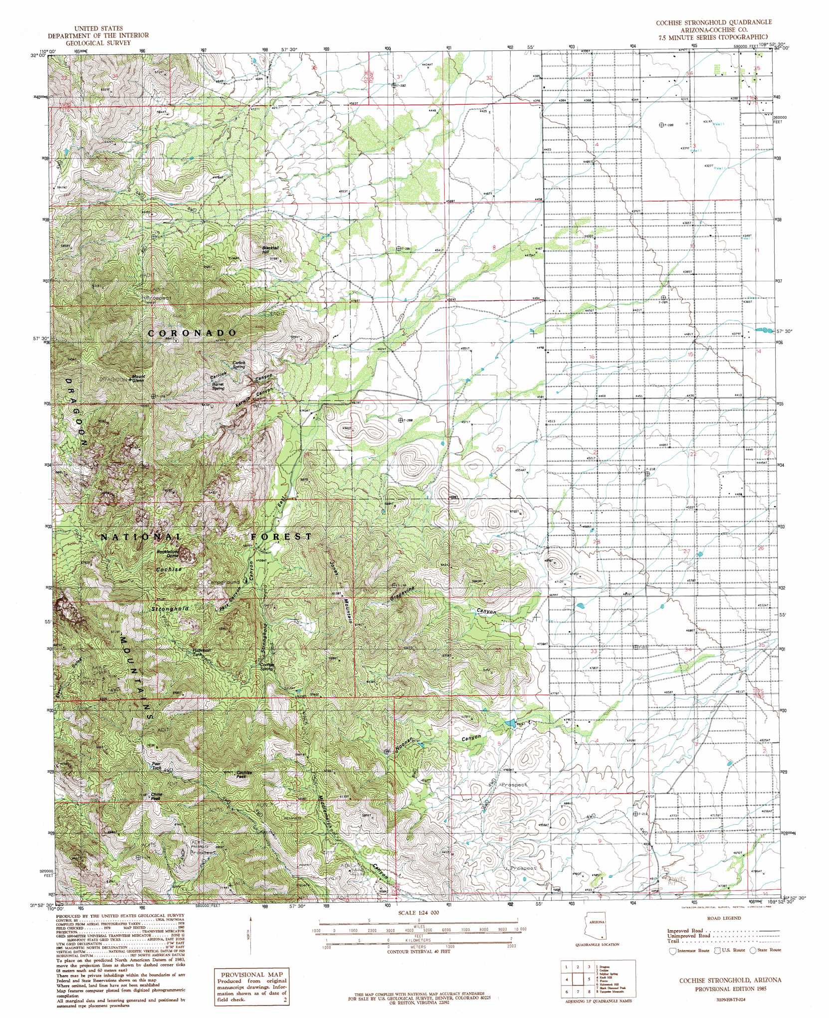
USGS Topo Quad 31109h8 - 1:24,000 scale
| Topo Map Name: | Cochise Stronghold |
| USGS Topo Quad ID: | 31109h8 |
| Print Size: | ca. 21 1/4" wide x 27" high |
| Southeast Coordinates: | 31.875° N latitude / 109.875° W longitude |
| Map Center Coordinates: | 31.9375° N latitude / 109.9375° W longitude |
| U.S. State: | AZ |
| Filename: | o31109h8.jpg |
| Download Map JPG Image: | Cochise Stronghold topo map 1:24,000 scale |
| Map Type: | Topographic |
| Topo Series: | 7.5´ |
| Map Scale: | 1:24,000 |
| Source of Map Images: | United States Geological Survey (USGS) |
| Alternate Map Versions: |
Cochise Stronghold AZ 1985, updated 1985 Download PDF Buy paper map Cochise Stronghold AZ 1996, updated 2002 Download PDF Buy paper map Cochise Stronghold AZ 2012 Download PDF Buy paper map Cochise Stronghold AZ 2014 Download PDF Buy paper map |
| FStopo: | US Forest Service topo Cochise Stronghold is available: Download FStopo PDF Download FStopo TIF |
1:24,000 Topo Quads surrounding Cochise Stronghold
Deepwell Ranch |
Steele Hills |
Red Bird Hills |
Willcox South |
Simmons Peak |
San Pedro Ranch |
Dragoon |
Cochise |
Sulphur Spring |
Dos Cabezas Sw |
Saint David |
Knob Hill |
Cochise Stronghold |
Pearce |
Sulphur Hills |
Land |
Haberstock Hill |
Black Diamond Peak |
Turquoise Mountain |
Squaretop Hills West |
Fairbank |
Tombstone |
Hay Mountain |
Outlaw Mountain |
Elfrida |
> Back to 31109e1 at 1:100,000 scale
> Back to 31108a1 at 1:250,000 scale
> Back to U.S. Topo Maps home
Cochise Stronghold topo map: Gazetteer
Cochise Stronghold: Areas
Cochise Stronghold elevation 1923m 6309′Cochise Stronghold: Mines
Abril Mine elevation 2031m 6663′Cobra Loma Mine elevation 1775m 5823′
Cochise Stronghold: Populated Places
Arizona Sun Sites elevation 1583m 5193′Cochise Stronghold: Ranges
Dragoon Mountains elevation 2084m 6837′Cochise Stronghold: Reservoirs
Halfmoon Tank elevation 1728m 5669′Johns Well elevation 1645m 5396′
Cochise Stronghold: Springs
Barret Spring elevation 1745m 5725′Tunnel Spring elevation 1660m 5446′
Cochise Stronghold: Summits
Blacktail Hill elevation 1635m 5364′China Peak elevation 2156m 7073′
Cochise Peak elevation 2030m 6660′
Jones Mountain elevation 1789m 5869′
Mount Glenn elevation 2288m 7506′
Rockfellow Dome elevation 1966m 6450′
Cochise Stronghold: Valleys
Grapevine Canyon elevation 1439m 4721′Noonan Canyon elevation 1456m 4776′
Stronghold Canyon East elevation 1416m 4645′
Cochise Stronghold digital topo map on disk
Buy this Cochise Stronghold topo map showing relief, roads, GPS coordinates and other geographical features, as a high-resolution digital map file on DVD: