Tecula Topo Map Texas
To zoom in, hover over the map of Tecula
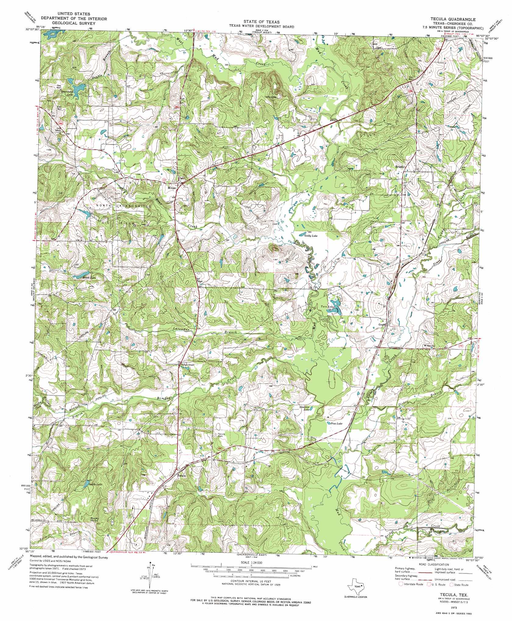
USGS Topo Quad 32095a2 - 1:24,000 scale
| Topo Map Name: | Tecula |
| USGS Topo Quad ID: | 32095a2 |
| Print Size: | ca. 21 1/4" wide x 27" high |
| Southeast Coordinates: | 32° N latitude / 95.125° W longitude |
| Map Center Coordinates: | 32.0625° N latitude / 95.1875° W longitude |
| U.S. State: | TX |
| Filename: | o32095a2.jpg |
| Download Map JPG Image: | Tecula topo map 1:24,000 scale |
| Map Type: | Topographic |
| Topo Series: | 7.5´ |
| Map Scale: | 1:24,000 |
| Source of Map Images: | United States Geological Survey (USGS) |
| Alternate Map Versions: |
Tecula TX 1973, updated 1976 Download PDF Buy paper map Tecula TX 2010 Download PDF Buy paper map Tecula TX 2012 Download PDF Buy paper map Tecula TX 2016 Download PDF Buy paper map |
1:24,000 Topo Quads surrounding Tecula
Chandler |
Tyler South |
Bascom |
Hope Pond |
Kilgore Sw |
Saline Bay |
Bullard |
Troup West |
Troup East |
Price |
Berryville |
Mount Selman |
Tecula |
Griffin |
Gum Springs |
Todd City |
Jacksonville West |
Jacksonville East |
New Summerfield |
New Salem |
Neches |
Maydelle |
Rusk |
Atoy |
Reklaw |
> Back to 32095a1 at 1:100,000 scale
> Back to 32094a1 at 1:250,000 scale
> Back to U.S. Topo Maps home
Tecula topo map: Gazetteer
Tecula: Dams
Bullard Club Lake Dam elevation 119m 390′Miles Lake Dam elevation 126m 413′
Tecula: Lakes
Goldy Lake elevation 92m 301′Pine Lake elevation 91m 298′
Stockton Lake elevation 89m 291′
Twin Lakes elevation 90m 295′
Tecula: Oilfields
North Jacksonville Oil Field elevation 121m 396′Tecula: Populated Places
Brushy elevation 128m 419′Gould elevation 107m 351′
Mixon elevation 124m 406′
Tecula elevation 125m 410′
Tecula: Reservoirs
Brock Lake elevation 120m 393′Bullard Club Lake elevation 119m 390′
Greenhead Lake elevation 115m 377′
Miles Lake elevation 126m 413′
Smith Lake elevation 119m 390′
Tecula: Streams
Bear Creek elevation 91m 298′Bell Branch elevation 91m 298′
Birches Creek elevation 88m 288′
Brushy Creek elevation 106m 347′
Caney Creek elevation 88m 288′
Club Lake Branch elevation 91m 298′
Dickey Branch elevation 90m 295′
Double Branch elevation 101m 331′
Hetty Branch elevation 102m 334′
Lavender Branch elevation 91m 298′
Piney Branch elevation 100m 328′
Wallace Branch elevation 106m 347′
West Mud Creek elevation 94m 308′
Tecula: Summits
Rocky Point elevation 147m 482′Tecula digital topo map on disk
Buy this Tecula topo map showing relief, roads, GPS coordinates and other geographical features, as a high-resolution digital map file on DVD: