Saint George Sw Topo Map South Carolina
To zoom in, hover over the map of Saint George Sw
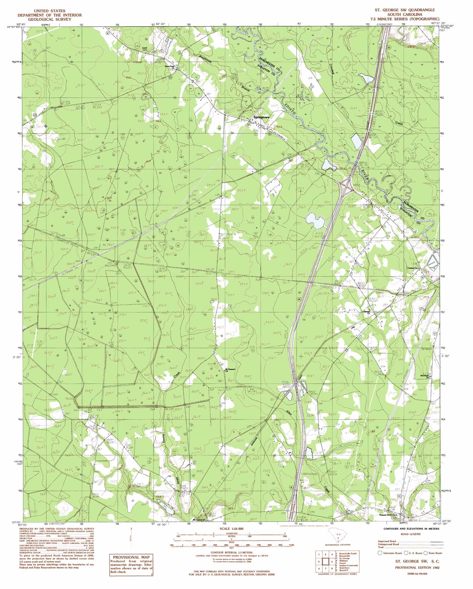
USGS Topo Quad 33080a6 - 1:24,000 scale
| Topo Map Name: | Saint George Sw |
| USGS Topo Quad ID: | 33080a6 |
| Print Size: | ca. 21 1/4" wide x 27" high |
| Southeast Coordinates: | 33° N latitude / 80.625° W longitude |
| Map Center Coordinates: | 33.0625° N latitude / 80.6875° W longitude |
| U.S. State: | SC |
| Filename: | o33080a6.jpg |
| Download Map JPG Image: | Saint George Sw topo map 1:24,000 scale |
| Map Type: | Topographic |
| Topo Series: | 7.5´ |
| Map Scale: | 1:24,000 |
| Source of Map Images: | United States Geological Survey (USGS) |
| Alternate Map Versions: |
St. George SW SC 1982, updated 1983 Download PDF Buy paper map Saint George SW SC 2011 Download PDF Buy paper map Saint George SW SC 2014 Download PDF Buy paper map |
1:24,000 Topo Quads surrounding Saint George Sw
Midway |
Branchville North |
Bowman |
Wadboo Swamp |
Holly Hill |
Tony Hill Bay |
Branchville South |
Reevesville |
Saint George |
Harleyville |
Lodge |
Williams |
Saint George Sw |
Canadys |
Maple Cane Swamp |
Islandton |
Sniders Crossroads |
Walterboro |
Round O |
Cottageville |
Cummings |
Black Creek |
Hendersonville |
Neyles |
Jacksonboro |
> Back to 33080a1 at 1:100,000 scale
> Back to 33080a1 at 1:250,000 scale
> Back to U.S. Topo Maps home
Saint George Sw topo map: Gazetteer
Saint George Sw: Bridges
Raysor Bridge elevation 21m 68′Saint George Sw: Crossings
Interchange 62 elevation 27m 88′Interchange 68 elevation 27m 88′
Saint George Sw: Dams
Cokers Pond Dam D-0649 elevation 22m 72′South Carolina Noname 15033 D-2388 Dam elevation 25m 82′
Saint George Sw: Lakes
Green Pond elevation 28m 91′Saint George Sw: Populated Places
Red Bank (historical) elevation 25m 82′Springtown elevation 24m 78′
Weeks elevation 26m 85′
Saint George Sw: Reservoirs
Cokers Pond elevation 22m 72′Saint George Sw: Streams
Brickhouse Branch elevation 21m 68′Saint George Sw digital topo map on disk
Buy this Saint George Sw topo map showing relief, roads, GPS coordinates and other geographical features, as a high-resolution digital map file on DVD:
South Carolina, Western North Carolina & Northeastern Georgia
Buy digital topo maps: South Carolina, Western North Carolina & Northeastern Georgia