Belzoni Topo Map Mississippi
To zoom in, hover over the map of Belzoni
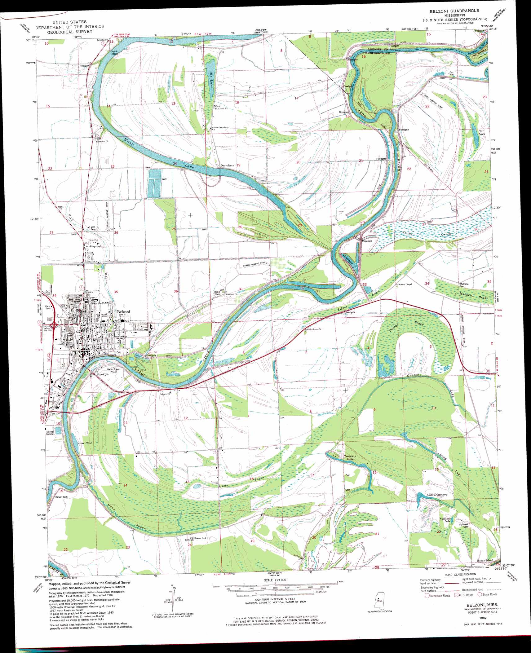
USGS Topo Quad 33090b4 - 1:24,000 scale
| Topo Map Name: | Belzoni |
| USGS Topo Quad ID: | 33090b4 |
| Print Size: | ca. 21 1/4" wide x 27" high |
| Southeast Coordinates: | 33.125° N latitude / 90.375° W longitude |
| Map Center Coordinates: | 33.1875° N latitude / 90.4375° W longitude |
| U.S. State: | MS |
| Filename: | o33090b4.jpg |
| Download Map JPG Image: | Belzoni topo map 1:24,000 scale |
| Map Type: | Topographic |
| Topo Series: | 7.5´ |
| Map Scale: | 1:24,000 |
| Source of Map Images: | United States Geological Survey (USGS) |
| Alternate Map Versions: |
Belzoni MS 1982, updated 1983 Download PDF Buy paper map Belzoni MS 2012 Download PDF Buy paper map Belzoni MS 2015 Download PDF Buy paper map |
1:24,000 Topo Quads surrounding Belzoni
Indianola |
Moorhead |
Colony Town |
Itta Bena |
Sidon |
Kinlock |
Inverness |
Swiftown |
Montgomery |
Cruger |
Midnight Nw |
Bellewood |
Belzoni |
Marcella |
Tchula |
Richey |
Midnight |
Silver City |
Thornton |
Howard |
Bayland |
Louise |
Carter |
Eden |
Zeiglerville |
> Back to 33090a1 at 1:100,000 scale
> Back to 33090a1 at 1:250,000 scale
> Back to U.S. Topo Maps home
Belzoni topo map: Gazetteer
Belzoni: Bends
Famosla Cut-Off elevation 29m 95′Pelican Bend elevation 33m 108′
Belzoni: Canals
Ditch Number Eighteen elevation 33m 108′Ditch Number Twenty One elevation 33m 108′
Ditch Number Twenty Seven elevation 32m 104′
Ditch Number Twenty Six elevation 34m 111′
Belzoni: Dams
Belzoni Lagoon Dam elevation 35m 114′Hawkins Lake Dam elevation 32m 104′
Paul Roberts Lake Dam elevation 34m 111′
Paul Thorton Lake Dam elevation 35m 114′
Thornton Lake Dam elevation 30m 98′
Belzoni: Guts
Fisk Bayou elevation 35m 114′Gum Bayou elevation 31m 101′
Belzoni: Islands
Honey Island elevation 33m 108′Belzoni: Lakes
Blue Hole elevation 32m 104′Deadman Lake elevation 29m 95′
Fullilove Lake elevation 32m 104′
Lake Discovery elevation 31m 101′
Long Lake elevation 34m 111′
Ole Lake elevation 33m 108′
Townson Lake elevation 32m 104′
Wasp Lake elevation 27m 88′
Belzoni: Populated Places
Belzoni elevation 34m 111′Brooklyn elevation 35m 114′
Deovolente elevation 34m 111′
Famosla elevation 35m 114′
Grass Lake elevation 35m 114′
Honey Island elevation 34m 111′
Mathena elevation 34m 111′
Belzoni: Streams
Bear Creek elevation 27m 88′Snake Creek elevation 27m 88′
Belzoni: Swamps
Toney Brake elevation 33m 108′Belzoni digital topo map on disk
Buy this Belzoni topo map showing relief, roads, GPS coordinates and other geographical features, as a high-resolution digital map file on DVD: