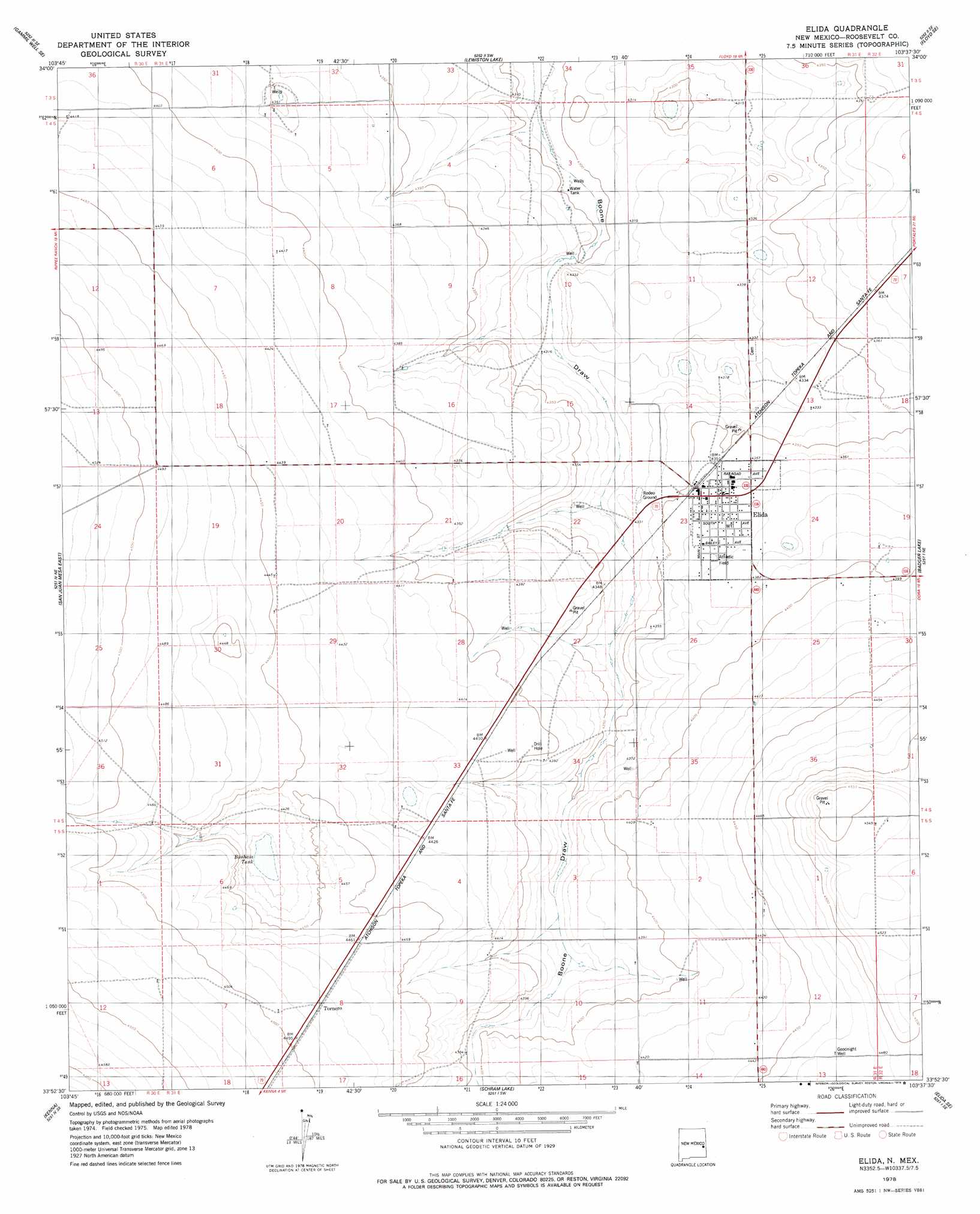
Elida Topo Map New Mexico
To zoom in, hover over the map of Elida
USGS Topo Quad 33103h6 - 1:24,000 scale
| Topo Map Name: | Elida |
| USGS Topo Quad ID: | 33103h6 |
| Print Size: | ca. 21 1/4" wide x 27" high |
| Southeast Coordinates: | 33.875° N latitude / 103.625° W longitude |
| Map Center Coordinates: | 33.9375° N latitude / 103.6875° W longitude |
| U.S. State: | NM |
| Filename: | o33103h6.jpg |
| Download Map JPG Image: | Elida topo map 1:24,000 scale |
| Map Type: | Topographic |
| Topo Series: | 7.5´ |
| Map Scale: | 1:24,000 |
| Source of Map Images: | United States Geological Survey (USGS) |
| Alternate Map Versions: |
Elida NM 1978, updated 1979 Download PDF Buy paper map Elida NM 2010 Download PDF Buy paper map Elida NM 2013 Download PDF Buy paper map Elida NM 2017 Download PDF Buy paper map |
1:24,000 Topo Quads surrounding Elida
Gammil Well |
Gammil Well Ne |
Upton |
Floyd |
Bethel |
Rippee Ranch |
Gammil Well Se |
Lewiston Lake |
Floyd Se |
Delphos |
San Juan Mesa West |
San Juan Mesa East |
Elida |
Badger Lake |
Dora Nw |
Kenna Sw |
Kenna |
Schram Lake |
Elida Se |
Dora Sw |
Curlew Lake |
Lone Wolf |
Button Mesa North |
Button Mesa Ne |
Milnesand Nw |
> Back to 33103e1 at 1:100,000 scale
> Back to 33102a1 at 1:250,000 scale
> Back to U.S. Topo Maps home
Elida topo map: Gazetteer
Elida: Parks
Castano de Sosas Route Historical Marker elevation 1329m 4360′Pecos Valley Historical Marker elevation 1329m 4360′
Elida: Populated Places
Elida elevation 1329m 4360′Tornero elevation 1368m 4488′
Elida: Post Offices
Elida Post Office elevation 1329m 4360′Elida: Reservoirs
Bonham Tank elevation 1345m 4412′Elida: Wells
06042 Water Well elevation 1320m 4330′06043 Water Well elevation 1336m 4383′
06048 Water Well elevation 1346m 4416′
06049 Water Well elevation 1354m 4442′
06055 Water Well elevation 1366m 4481′
06056 Water Well elevation 1331m 4366′
06057 Water Well elevation 1342m 4402′
06058 Water Well elevation 1312m 4304′
06059 Water Well elevation 1325m 4347′
06060 Water Well elevation 1322m 4337′
06061 Water Well elevation 1316m 4317′
06062 Water Well elevation 1328m 4356′
06063 Water Well elevation 1316m 4317′
06064 Water Well elevation 1337m 4386′
06065 Water Well elevation 1344m 4409′
06066 Water Well elevation 1352m 4435′
06067 Water Well elevation 1339m 4393′
06068 Water Well elevation 1327m 4353′
06069 Water Well elevation 1334m 4376′
06070 Water Well elevation 1331m 4366′
06071 Water Well elevation 1323m 4340′
06072 Water Well elevation 1336m 4383′
06073 Water Well elevation 1351m 4432′
06100 Water Well elevation 1347m 4419′
06102 Water Well elevation 1339m 4393′
06103 Water Well elevation 1339m 4393′
06104 Water Well elevation 1344m 4409′
06105 Water Well elevation 1340m 4396′
06106 Water Well elevation 1358m 4455′
06107 Water Well elevation 1365m 4478′
06108 Water Well elevation 1349m 4425′
Elida digital topo map on disk
Buy this Elida topo map showing relief, roads, GPS coordinates and other geographical features, as a high-resolution digital map file on DVD: