Garden Spring Canyon Topo Map New Mexico
To zoom in, hover over the map of Garden Spring Canyon
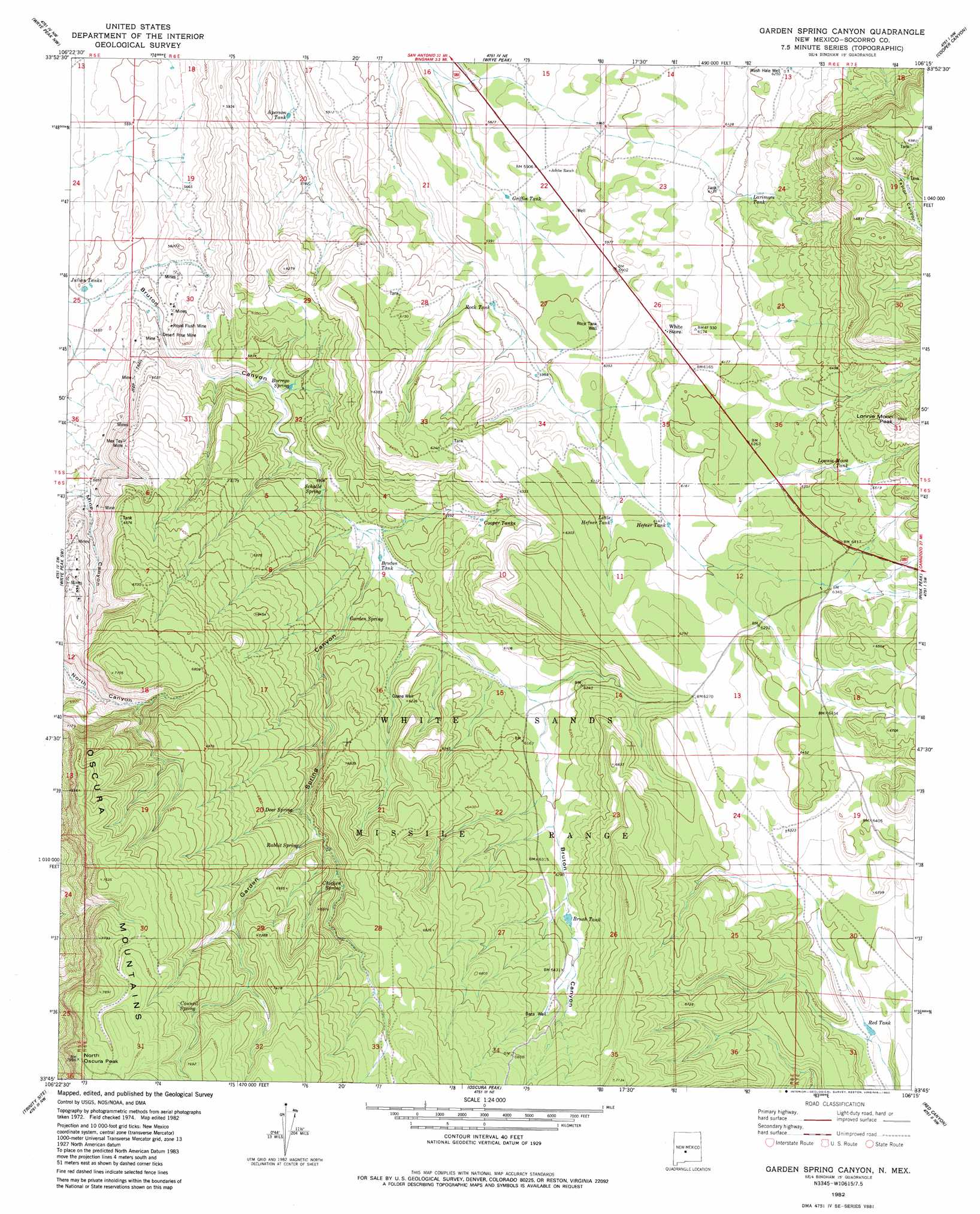
USGS Topo Quad 33106g3 - 1:24,000 scale
| Topo Map Name: | Garden Spring Canyon |
| USGS Topo Quad ID: | 33106g3 |
| Print Size: | ca. 21 1/4" wide x 27" high |
| Southeast Coordinates: | 33.75° N latitude / 106.25° W longitude |
| Map Center Coordinates: | 33.8125° N latitude / 106.3125° W longitude |
| U.S. State: | NM |
| Filename: | o33106g3.jpg |
| Download Map JPG Image: | Garden Spring Canyon topo map 1:24,000 scale |
| Map Type: | Topographic |
| Topo Series: | 7.5´ |
| Map Scale: | 1:24,000 |
| Source of Map Images: | United States Geological Survey (USGS) |
| Alternate Map Versions: |
Garden Spring Canyon NM 1982, updated 1982 Download PDF Buy paper map Garden Spring Canyon NM 2010 Download PDF Buy paper map Garden Spring Canyon NM 2013 Download PDF Buy paper map Garden Spring Canyon NM 2017 Download PDF Buy paper map |
1:24,000 Topo Quads surrounding Garden Spring Canyon
Sierra Larga South |
Orndorff Ranch |
Wilson Ranch |
Turkey Ridge Sw |
Cat Mesa |
Prairie Spring |
Wrye Peak Nw |
Wrye Peak |
Cooper Canyon |
Lovelace Mesa |
Cerro De La Campana Se |
Wrye Peak Sw |
Garden Spring Canyon |
Pink Peak |
Broken Back Crater |
Greens Baber Well |
Trinity Site |
Oscura Peak |
Red Canyon |
Wagon Canyon |
Foster Well |
Mockingbird Gap |
Mockingbird Gap Se |
Bull Gap Sw |
Bull Gap |
> Back to 33106e1 at 1:100,000 scale
> Back to 33106a1 at 1:250,000 scale
> Back to U.S. Topo Maps home
Garden Spring Canyon topo map: Gazetteer
Garden Spring Canyon: Mines
Desert Rose Mine elevation 1708m 5603′Hickey Number 1 Mine elevation 1772m 5813′
Lorenzo Tunnel elevation 1909m 6263′
Mex Tex Mine elevation 1880m 6167′
Mountain Canyon Mine elevation 1723m 5652′
Ora Mine elevation 1767m 5797′
Royal Flush Mine elevation 1722m 5649′
Garden Spring Canyon: Populated Places
Adobe Ranch elevation 1803m 5915′Coane elevation 1854m 6082′
Garden Spring Canyon: Post Offices
Adobe Post Office (historical) elevation 1803m 5915′Garden Spring Canyon: Reservoirs
Aperson Tank elevation 1745m 5725′Baca Tank elevation 1986m 6515′
Brush Tank elevation 1931m 6335′
Bruton Tank elevation 1806m 5925′
Cooper Tanks elevation 1849m 6066′
Griffin Tank elevation 1792m 5879′
Hefner Tank elevation 1877m 6158′
Julian Tanks elevation 1698m 5570′
Larimore Tank elevation 1899m 6230′
Little Hefner Tank elevation 1877m 6158′
Lonnie Moon Tank elevation 1965m 6446′
Red Tank elevation 1859m 6099′
Rock Tank elevation 1807m 5928′
Garden Spring Canyon: Springs
Burrego Spring elevation 1766m 5793′Chicken Spring elevation 2042m 6699′
Council Spring elevation 2285m 7496′
Deer Spring elevation 2013m 6604′
Garden Spring elevation 1834m 6017′
Rabbit Spring elevation 2000m 6561′
Schalle Spring elevation 1793m 5882′
Garden Spring Canyon: Summits
Lonnie Moon Peak elevation 2105m 6906′North Oscura Peak elevation 2431m 7975′
Garden Spring Canyon: Wells
A F Baca Water Well elevation 2083m 6833′Baca Well elevation 1987m 6519′
Ozane Well elevation 1886m 6187′
Rock Tank Well elevation 1842m 6043′
Rock Tank Well elevation 1773m 5816′
Garden Spring Canyon digital topo map on disk
Buy this Garden Spring Canyon topo map showing relief, roads, GPS coordinates and other geographical features, as a high-resolution digital map file on DVD: