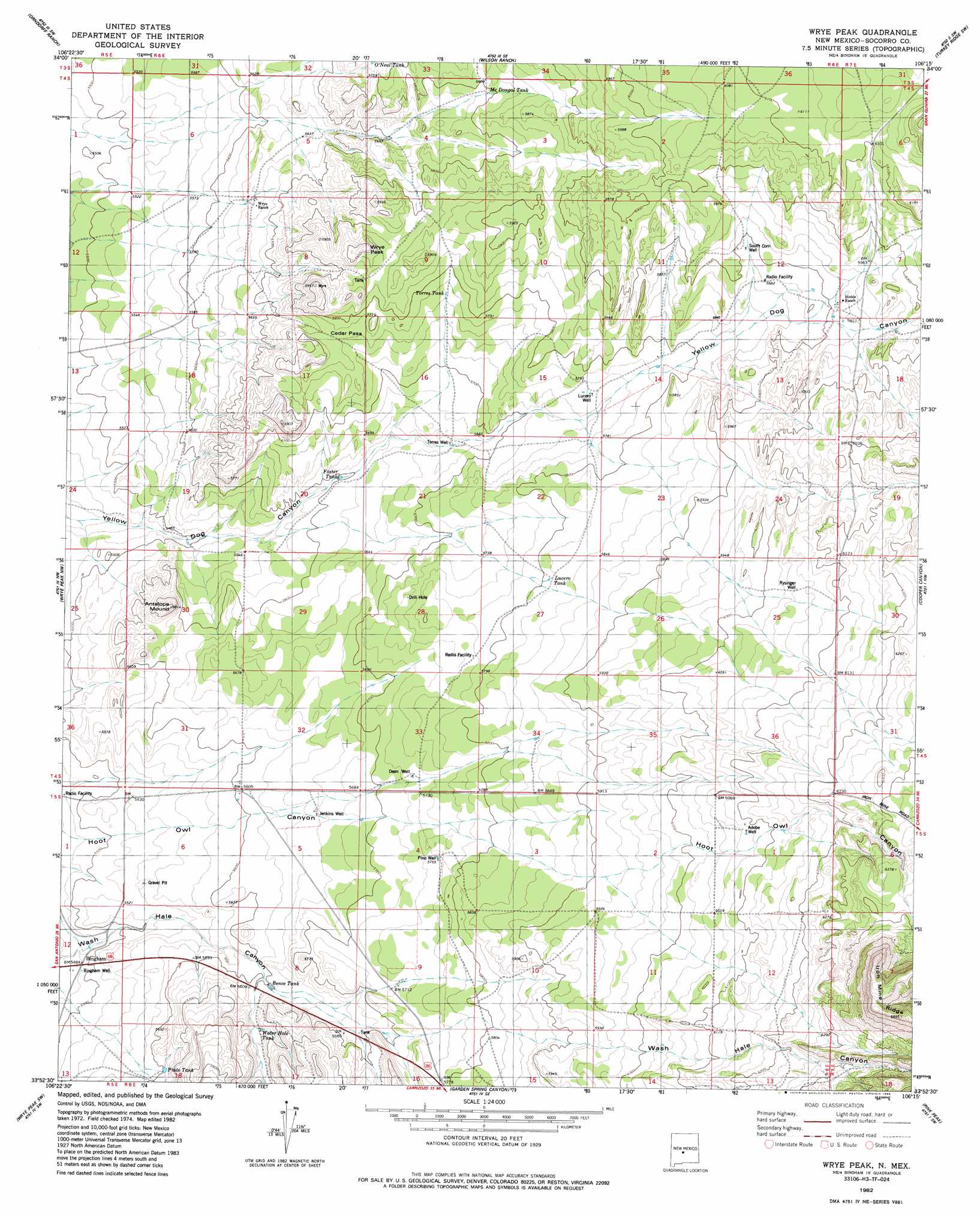
Wrye Peak Topo Map New Mexico
To zoom in, hover over the map of Wrye Peak
USGS Topo Quad 33106h3 - 1:24,000 scale
| Topo Map Name: | Wrye Peak |
| USGS Topo Quad ID: | 33106h3 |
| Print Size: | ca. 21 1/4" wide x 27" high |
| Southeast Coordinates: | 33.875° N latitude / 106.25° W longitude |
| Map Center Coordinates: | 33.9375° N latitude / 106.3125° W longitude |
| U.S. State: | NM |
| Filename: | o33106h3.jpg |
| Download Map JPG Image: | Wrye Peak topo map 1:24,000 scale |
| Map Type: | Topographic |
| Topo Series: | 7.5´ |
| Map Scale: | 1:24,000 |
| Source of Map Images: | United States Geological Survey (USGS) |
| Alternate Map Versions: |
Wrye Peak NM 1982, updated 1982 Download PDF Buy paper map Wrye Peak NM 1982, updated 1986 Download PDF Buy paper map Wrye Peak NM 2010 Download PDF Buy paper map Wrye Peak NM 2013 Download PDF Buy paper map Wrye Peak NM 2017 Download PDF Buy paper map |
1:24,000 Topo Quads surrounding Wrye Peak
Sierra Larga North |
Bishop Ranch |
Chupadera Spring |
Turkey Ridge |
Turkey Ridge Ne |
Sierra Larga South |
Orndorff Ranch |
Wilson Ranch |
Turkey Ridge Sw |
Cat Mesa |
Prairie Spring |
Wrye Peak Nw |
Wrye Peak |
Cooper Canyon |
Lovelace Mesa |
Cerro De La Campana Se |
Wrye Peak Sw |
Garden Spring Canyon |
Pink Peak |
Broken Back Crater |
Greens Baber Well |
Trinity Site |
Oscura Peak |
Red Canyon |
Wagon Canyon |
> Back to 33106e1 at 1:100,000 scale
> Back to 33106a1 at 1:250,000 scale
> Back to U.S. Topo Maps home
Wrye Peak topo map: Gazetteer
Wrye Peak: Gaps
Cedar Pass elevation 1759m 5770′Wrye Peak: Populated Places
Bingham elevation 1672m 5485′Wrye Peak: Post Offices
Bingham Post Office elevation 1709m 5606′Wrye Peak: Reservoirs
Bence Tank elevation 1701m 5580′Foster Tank elevation 1710m 5610′
Lucero Tank elevation 1773m 5816′
McDougal Tank elevation 1767m 5797′
Pinto Tank elevation 1711m 5613′
Torres Tank elevation 1760m 5774′
Wrye Peak: Summits
Antelope Mound elevation 1765m 5790′Wrye Peak elevation 1803m 5915′
Wrye Peak: Wells
10050 Water Well elevation 1756m 5761′Adobe Well elevation 1851m 6072′
Bingham Well elevation 1673m 5488′
Dean Well elevation 1746m 5728′
G Lucero Well elevation 1770m 5807′
Hale Well elevation 1908m 6259′
Jenkins Well elevation 1724m 5656′
Pino Well elevation 1756m 5761′
RG 38235 Water Well elevation 1779m 5836′
Rysinger Well elevation 1844m 6049′
South Well elevation 1689m 5541′
Torres Well elevation 1723m 5652′
Wrye Peak digital topo map on disk
Buy this Wrye Peak topo map showing relief, roads, GPS coordinates and other geographical features, as a high-resolution digital map file on DVD: