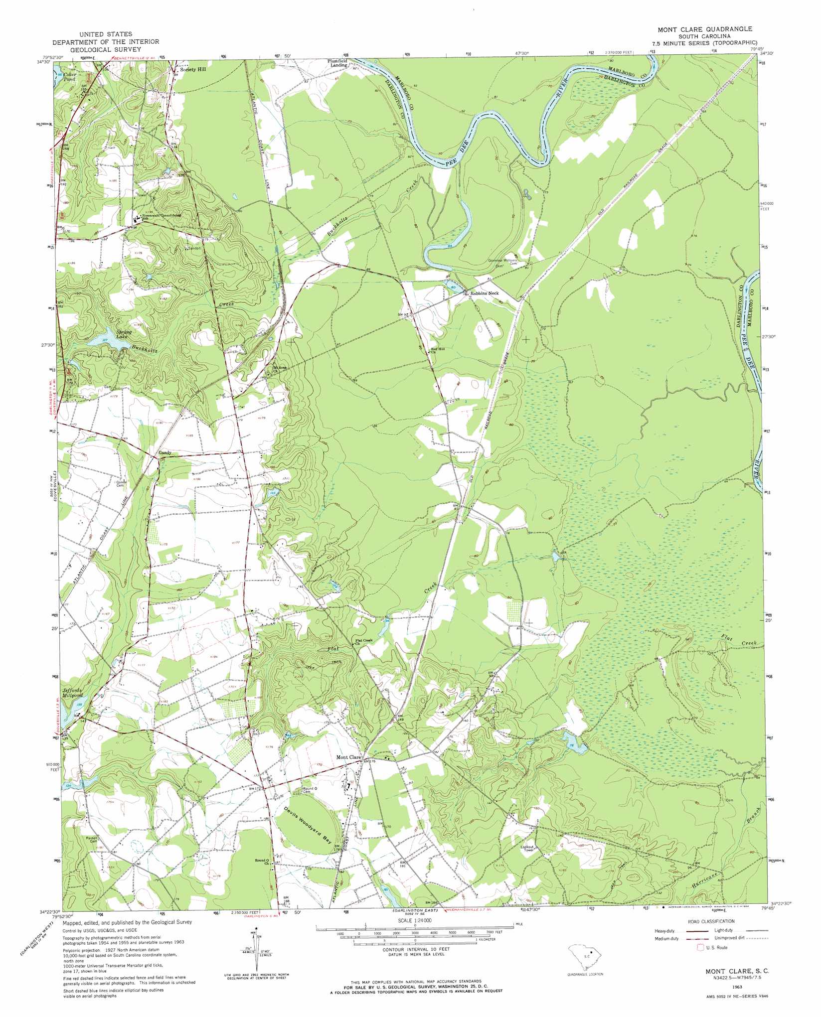
Mont Clare Topo Map South Carolina
To zoom in, hover over the map of Mont Clare
USGS Topo Quad 34079d7 - 1:24,000 scale
| Topo Map Name: | Mont Clare |
| USGS Topo Quad ID: | 34079d7 |
| Print Size: | ca. 21 1/4" wide x 27" high |
| Southeast Coordinates: | 34.375° N latitude / 79.75° W longitude |
| Map Center Coordinates: | 34.4375° N latitude / 79.8125° W longitude |
| U.S. State: | SC |
| Filename: | o34079d7.jpg |
| Download Map JPG Image: | Mont Clare topo map 1:24,000 scale |
| Map Type: | Topographic |
| Topo Series: | 7.5´ |
| Map Scale: | 1:24,000 |
| Source of Map Images: | United States Geological Survey (USGS) |
| Alternate Map Versions: |
Mont Clare SC 1963, updated 1964 Download PDF Buy paper map Mont Clare SC 2011 Download PDF Buy paper map Mont Clare SC 2014 Download PDF Buy paper map |
1:24,000 Topo Quads surrounding Mont Clare
Chesterfield |
Cheraw |
Wallace |
Bennettsville North |
Mccoll |
Patrick |
Cash |
Society Hill |
Bennettsville South |
Clio |
Hartsville North |
Dovesville |
Mont Clare |
Drake |
Bingham |
Hartsville South |
Darlington West |
Darlington East |
Witherspoon Island |
Oak Grove |
Lamar |
Timmonsville |
Florence West |
Florence East |
Pee Dee |
> Back to 34079a1 at 1:100,000 scale
> Back to 34078a1 at 1:250,000 scale
> Back to U.S. Topo Maps home
Mont Clare topo map: Gazetteer
Mont Clare: Basins
Devils Woodyard Bay elevation 54m 177′Mont Clare: Dams
Jeffords Pond Dam D-3541 elevation 40m 131′South Carolina Noname 16008 D-3540 Dam elevation 24m 78′
South Carolina Noname 16024 D-3539 Dam elevation 39m 127′
Mont Clare: Falls
Cockers Falls elevation 18m 59′Mont Clare: Lakes
Coker Pond elevation 29m 95′Williams Lake elevation 19m 62′
Mont Clare: Populated Places
Gandy elevation 53m 173′Lumber (historical) elevation 27m 88′
Mont Clare elevation 52m 170′
Robbins Neck elevation 25m 82′
Mont Clare: Reservoirs
Jeffords Millpond elevation 42m 137′Spring Lake elevation 38m 124′
Wilbur Flowers Pond elevation 39m 127′
Mont Clare: Streams
Buckholtz Creek elevation 21m 68′Mont Clare digital topo map on disk
Buy this Mont Clare topo map showing relief, roads, GPS coordinates and other geographical features, as a high-resolution digital map file on DVD:
South Carolina, Western North Carolina & Northeastern Georgia
Buy digital topo maps: South Carolina, Western North Carolina & Northeastern Georgia