Florence West Topo Map South Carolina
To zoom in, hover over the map of Florence West
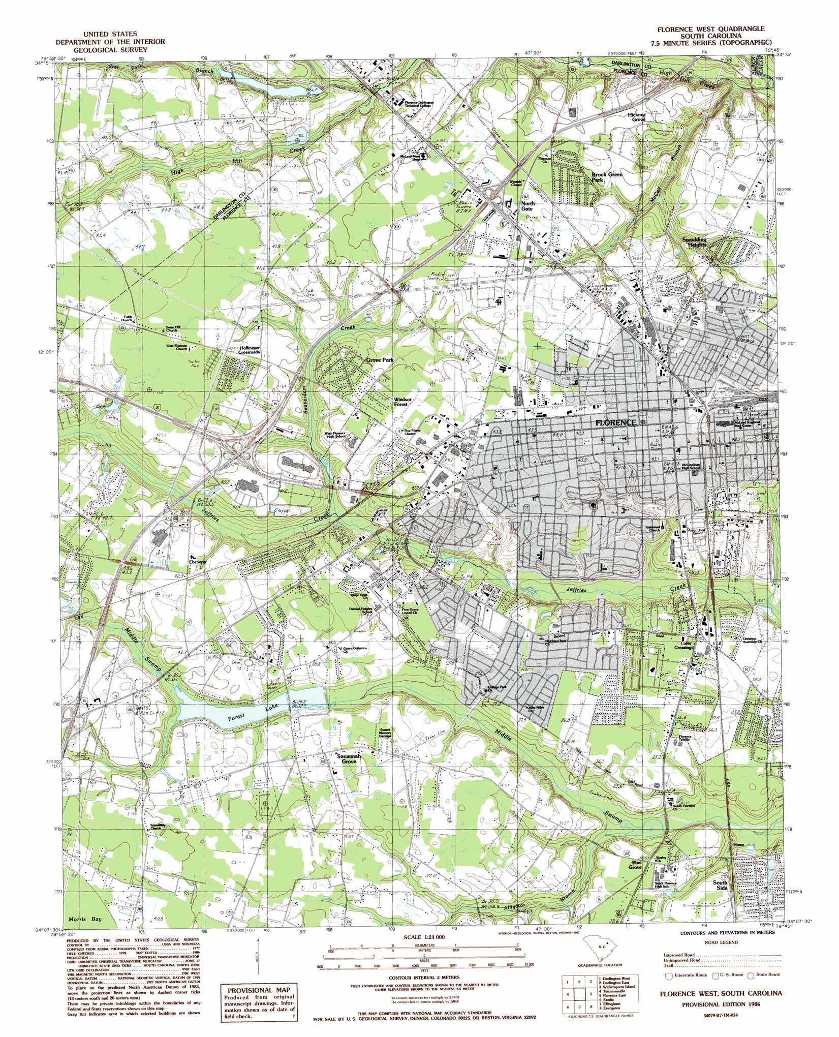
USGS Topo Quad 34079b7 - 1:24,000 scale
| Topo Map Name: | Florence West |
| USGS Topo Quad ID: | 34079b7 |
| Print Size: | ca. 21 1/4" wide x 27" high |
| Southeast Coordinates: | 34.125° N latitude / 79.75° W longitude |
| Map Center Coordinates: | 34.1875° N latitude / 79.8125° W longitude |
| U.S. State: | SC |
| Filename: | o34079b7.jpg |
| Download Map JPG Image: | Florence West topo map 1:24,000 scale |
| Map Type: | Topographic |
| Topo Series: | 7.5´ |
| Map Scale: | 1:24,000 |
| Source of Map Images: | United States Geological Survey (USGS) |
| Alternate Map Versions: |
Florence West SC 1986, updated 1987 Download PDF Buy paper map Florence West SC 1986, updated 1987 Download PDF Buy paper map Florence West SC 2011 Download PDF Buy paper map Florence West SC 2014 Download PDF Buy paper map |
1:24,000 Topo Quads surrounding Florence West
Hartsville North |
Dovesville |
Mont Clare |
Drake |
Bingham |
Hartsville South |
Darlington West |
Darlington East |
Witherspoon Island |
Oak Grove |
Lamar |
Timmonsville |
Florence West |
Florence East |
Pee Dee |
Lynchburg |
Sardis |
Effingham |
Evergreen |
Pamplico North |
Turbeville |
Olanta |
Mill Bay |
Scranton |
Pamplico South |
> Back to 34079a1 at 1:100,000 scale
> Back to 34078a1 at 1:250,000 scale
> Back to U.S. Topo Maps home
Florence West topo map: Gazetteer
Florence West: Crossings
Interchange 141 elevation 42m 137′Interchange 157 elevation 45m 147′
Interchange 160 elevation 42m 137′
Interchange 164 elevation 43m 141′
Florence West: Dams
Murry Pond Dam D-3573 elevation 34m 111′South Carolina Noname 16002 D-3556 Dam elevation 30m 98′
South Carolina Noname 21002 D-3557 Dam elevation 31m 101′
South Carolina Noname 21022 D-3570 Dam elevation 26m 85′
Florence West: Parks
American Legion Stadium elevation 44m 144′Chase Park elevation 42m 137′
David H McLeod Park elevation 36m 118′
Friendship Park elevation 36m 118′
Iola Jones Park elevation 44m 144′
Jeffries Creek Park elevation 28m 91′
Lucas Park elevation 32m 104′
Maple Park elevation 43m 141′
Northwest Community Park elevation 44m 144′
Rainwater Park elevation 40m 131′
Revell Park elevation 40m 131′
Timrod Park elevation 32m 104′
Florence West: Populated Places
Alligator Lake elevation 36m 118′Arrowood elevation 40m 131′
Ashwood Estates elevation 34m 111′
Bannockburn elevation 28m 91′
Belleview elevation 37m 121′
Benson Acres elevation 41m 134′
Botany Acres elevation 39m 127′
Briarcliff elevation 40m 131′
Brook Green Park elevation 42m 137′
Camellia Gardens elevation 43m 141′
Cloisters elevation 36m 118′
Coles Crossing elevation 34m 111′
College Park elevation 37m 121′
Colonial Forest elevation 38m 124′
Country Club Estates elevation 39m 127′
Country Club Forest elevation 39m 127′
Crownland Estates elevation 36m 118′
Cypress Point elevation 30m 98′
Deerfield elevation 34m 111′
Delmar Heights elevation 38m 124′
Ebenezer elevation 43m 141′
Enchanted Meadows elevation 35m 114′
Fairlane Estates elevation 33m 108′
Florence elevation 42m 137′
Forest Lake South elevation 37m 121′
Foxcroft elevation 41m 134′
Grove Park elevation 41m 134′
Hickory Grove elevation 39m 127′
Highland Park (historical) elevation 35m 114′
Hillcrest elevation 39m 127′
Hoffmeyer Crossroads elevation 40m 131′
Howe elevation 32m 104′
Huntington Place elevation 36m 118′
Kings Grant elevation 38m 124′
Kirkwood elevation 36m 118′
Lakeside elevation 33m 108′
Lakewood elevation 42m 137′
Landmark Woods elevation 41m 134′
Laurelwood elevation 40m 131′
Lazar Place elevation 36m 118′
Lee Acres elevation 38m 124′
Longleaf elevation 36m 118′
Mayfair elevation 38m 124′
Muldrows Mill elevation 34m 111′
Nob Hill elevation 34m 111′
North Gate elevation 41m 134′
Oak Forest elevation 41m 134′
Palmetto Shores elevation 37m 121′
Pine Forest Plantation elevation 35m 114′
Pine Grove elevation 34m 111′
Pineneedles elevation 42m 137′
Ridgecrest elevation 39m 127′
Rose Hill elevation 39m 127′
Sandhurst elevation 37m 121′
Savannah Grove elevation 38m 124′
Siesta Village elevation 34m 111′
South Park elevation 37m 121′
South Point elevation 37m 121′
South Side elevation 31m 101′
Spaulding Heights elevation 42m 137′
Springdale Place elevation 41m 134′
Suburbia elevation 37m 121′
Sunset Acres elevation 39m 127′
Sweetbriar elevation 35m 114′
Tara Hills elevation 27m 88′
Tara Village elevation 34m 111′
Tarleton Estates elevation 37m 121′
Waterford elevation 37m 121′
Williams Heights elevation 42m 137′
Wilson Estates elevation 42m 137′
Wilson Heights elevation 43m 141′
Windsor Forest elevation 42m 137′
Woodland Park elevation 36m 118′
Wren Creek elevation 32m 104′
Florence West: Post Offices
Federal Station Post Office elevation 43m 141′Florence Post Office elevation 44m 144′
South Florence Post Office elevation 35m 114′
Florence West: Reservoirs
Forest Lake elevation 31m 101′Muldrows Mill Pond elevation 26m 85′
Murry Pond elevation 34m 111′
Palmetto Shores Lake elevation 30m 98′
Tara Lake elevation 30m 98′
Florence West: Streams
Alligator Branch elevation 35m 114′Beaverdam Creek elevation 30m 98′
High Hill Creek elevation 19m 62′
McCall Branch elevation 24m 78′
Star Fork Branch elevation 29m 95′
Florence West digital topo map on disk
Buy this Florence West topo map showing relief, roads, GPS coordinates and other geographical features, as a high-resolution digital map file on DVD:
South Carolina, Western North Carolina & Northeastern Georgia
Buy digital topo maps: South Carolina, Western North Carolina & Northeastern Georgia