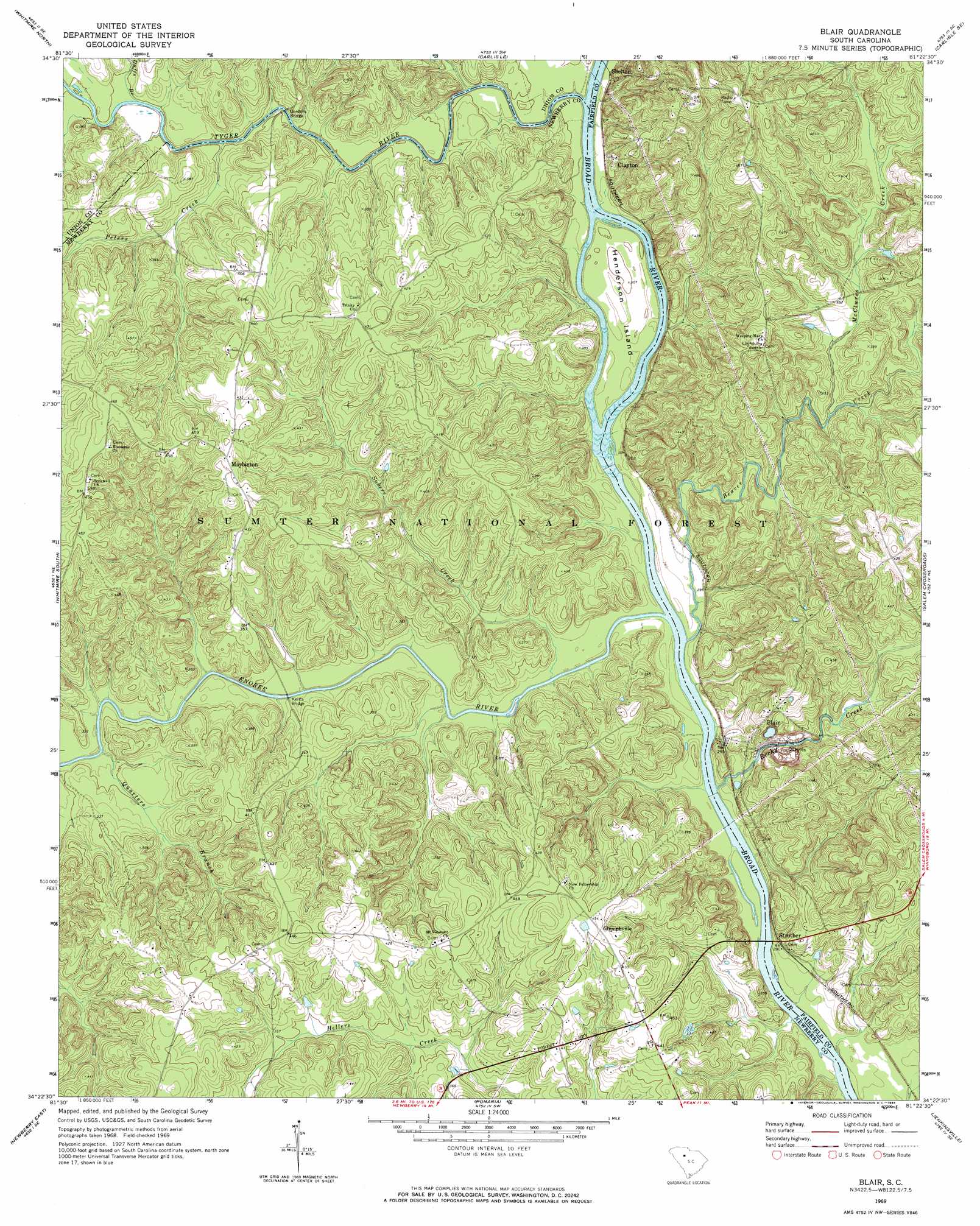
Blair Topo Map South Carolina
To zoom in, hover over the map of Blair
USGS Topo Quad 34081d4 - 1:24,000 scale
| Topo Map Name: | Blair |
| USGS Topo Quad ID: | 34081d4 |
| Print Size: | ca. 21 1/4" wide x 27" high |
| Southeast Coordinates: | 34.375° N latitude / 81.375° W longitude |
| Map Center Coordinates: | 34.4375° N latitude / 81.4375° W longitude |
| U.S. State: | SC |
| Filename: | o34081d4.jpg |
| Download Map JPG Image: | Blair topo map 1:24,000 scale |
| Map Type: | Topographic |
| Topo Series: | 7.5´ |
| Map Scale: | 1:24,000 |
| Source of Map Images: | United States Geological Survey (USGS) |
| Alternate Map Versions: |
Blair SC 1969, updated 1972 Download PDF Buy paper map Blair SC 1969, updated 1984 Download PDF Buy paper map Blair SC 2011 Download PDF Buy paper map Blair SC 2014 Download PDF Buy paper map |
| FStopo: | US Forest Service topo Blair is available: Download FStopo PDF Download FStopo TIF |
1:24,000 Topo Quads surrounding Blair
Union West |
Union East |
Leeds |
Baton Rouge |
Chester |
Sedalia |
Whitmire North |
Carlisle |
Carlisle Se |
Blackstock |
Newberry Nw |
Whitmire South |
Blair |
Salem Crossroads |
Lebanon |
Newberry West |
Newberry East |
Pomaria |
Jenkinsville |
Rion |
Silverstreet |
Prosperity |
Little Mountain |
Chapin |
Richtex |
> Back to 34081a1 at 1:100,000 scale
> Back to 34080a1 at 1:250,000 scale
> Back to U.S. Topo Maps home
Blair topo map: Gazetteer
Blair: Bridges
Gordons Bridge elevation 91m 298′Hendersons Bridge (historical) elevation 83m 272′
Keitts Bridge elevation 83m 272′
Blair: Crossings
Ashford Ferry (historical) elevation 82m 269′Blairs Ferry (historical) elevation 83m 272′
Clayton Ferry (historical) elevation 83m 272′
David Sims Ferry (historical) elevation 83m 272′
Greenshaws Ford elevation 92m 301′
Henderson Ferry (historical) elevation 83m 272′
Lyles Ford elevation 83m 272′
Blair: Islands
Henderson Island elevation 88m 288′Blair: Mines
Blair Quarry elevation 85m 278′Blair: Parks
Broad River Scenic Area elevation 105m 344′Blair: Populated Places
Blair elevation 119m 390′Clayton elevation 113m 370′
Gilliam Spring (historical) elevation 106m 347′
Glymphville elevation 141m 462′
Lylesford (historical) elevation 90m 295′
Maybinton elevation 135m 442′
Shelton elevation 100m 328′
Strother elevation 90m 295′
Blair: Springs
Gilliam Spring elevation 87m 285′Blair: Streams
Beaver Creek elevation 83m 272′Big Dryer Creek elevation 83m 272′
Cane Creek elevation 83m 272′
Duffs Branch elevation 92m 301′
Enoree River elevation 83m 272′
Keitts River elevation 83m 272′
Kellys Creek elevation 83m 272′
McClures Creek elevation 90m 295′
Old Ridge Branch elevation 82m 269′
Peters Creek elevation 90m 295′
Quarters Branch elevation 84m 275′
Rennicks Branch elevation 91m 298′
Rocky Creek elevation 83m 272′
Subers Creek elevation 83m 272′
Tyger River elevation 83m 272′
Blair digital topo map on disk
Buy this Blair topo map showing relief, roads, GPS coordinates and other geographical features, as a high-resolution digital map file on DVD:
South Carolina, Western North Carolina & Northeastern Georgia
Buy digital topo maps: South Carolina, Western North Carolina & Northeastern Georgia